103rd Street station (IND Eighth Avenue Line)
103 Street | |||
|---|---|---|---|
 Downtown platform on lower level | |||
| Station statistics | |||
| Address | West 103rd Street & Central Park West New York, NY 10025 | ||
| Borough | Manhattan | ||
| Locale | Upper West Side | ||
| Coordinates | 40°47′46″N 73°57′41″W / 40.79604°N 73.96142°WCoordinates: 40°47′46″N 73°57′41″W / 40.79604°N 73.96142°W | ||
| Division | B (IND)[1] | ||
| Line | IND Eighth Avenue Line | ||
| Services | A B C | ||
| Transit | |||
| Structure | Underground | ||
| Levels | 2 | ||
| Platforms | 2 side platforms (1 on each level) | ||
| Tracks | 4 (2 on lower level, 1 on upper level, 1 on ramp from upper to lower level) | ||
| Other information | |||
| Opened | September 10, 1932[2] | ||
| Station code | 156[3] | ||
| Opposite- direction transfer | Yes | ||
| Traffic | |||
| 2019 | 1,498,363[5] | ||
| Rank | 299 out of 424[5] | ||
| Station succession | |||
| Next north | Cathedral Parkway–110th Street: A | ||
| Next south | 96th Street: A | ||
| |||
| |||
| |||
| |||


103rd Street is a local station on the IND Eighth Avenue Line of the New York City Subway. Located at West 103rd Street and Central Park West on the Upper West Side, it is served by the B on weekdays, the C train at all times except nights, and the A train during late nights only.
History[]
The station opened on September 10, 1932, as part of the city-operated Independent Subway System (IND)'s initial segment, the Eighth Avenue Line between Chambers Street and 207th Street.[6][2] Construction of the whole line cost $191.2 million. While the IRT Broadway–Seventh Avenue Line already provided parallel service, the new Eighth Avenue subway via Central Park West provided an alternative route.[7]
Station layout[]
| G | Street level | Exit/entrance |
| B1 | Northbound express | ← |
| Northbound local | ← ← ← | |
| Side platform | ||
| Mezzanine | Fare control, station agent, MetroCard machines | |
| B2 | Southbound express | |
| Southbound local | | |
| Side platform | ||
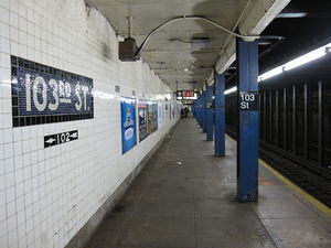
This underground station has two levels with northbound trains using the upper level and southbound trains using the lower one. Each level has one side platform to the west of two tracks.[8]
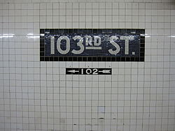
Both platforms have no trim line, but name tablets read "103RD ST." in white sans-serif lettering on a midnight blue background and black border. Small black "103" signs with white numbering run along the tiles at regular intervals and directional signs in the same style are below the name tablets. Blue columns run along both platforms at regular intervals with every other one having the standard black station name plate in white numbering.
Within this station, the northbound express track descends to allow the northbound local to cross over it, before rising up at 110th Street, where the line becomes the standard four tracks side by side with the local tracks on the side and express tracks in the center.[8]
The IRT Lenox Avenue Line passes underneath this station at the extreme north end on West 104th Street to Central Park North–110th Street. The line is not visible from the platforms. On the east side of Central Park West and West 104th Street, adjacent to Central Park, is an emergency exit enclosed in a small brick house for the IRT line, which passes underneath the station. From here the line curves northeast, running directly under Central Park's North Woods at this point.
Exit[]
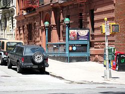
This station has one fare control area at the center of the upper-level platform. A single staircase connects the two platforms before a turnstile bank leads to a token booth and one staircase going up to the northwest corner of West 103rd Street and Central Park West. The station is unique in that it has only one open staircase to street level.[9]
Directional signs that have been covered indicate that there were two more fare control areas. One exit at the extreme south end had two staircases going to southwestern corner of West 102nd Street and Central Park West, and the other at the extreme north end had two that went to both western corners of West 104th Street.[10] Further evidence of these exits' existences includes new tiling on both levels, and doorways that lead to converted storage spaces on the upper level. The fare control area with stairs to West 104th Street was closed by 1940[11] and possibly as early as November 1932 - just two months after the opening of the station - due to frequent vandalism.[12]
References[]
- ^ "Glossary". Second Avenue Subway Supplemental Draft Environmental Impact Statement (SDEIS) (PDF). 1. Metropolitan Transportation Authority. March 4, 2003. pp. 1–2. Archived from the original (PDF) on February 26, 2021. Retrieved January 1, 2021.
- ^ Jump up to: a b "List of the 28 Stations on the New 8th Av. Line". The New York Times. September 10, 1932. p. 6. ISSN 0362-4331. Retrieved April 21, 2020.
- ^ "Station Developers' Information". Metropolitan Transportation Authority. Retrieved June 13, 2017.
- ^ "Facts and Figures: Annual Subway Ridership 2014–2019". Metropolitan Transportation Authority. 2020. Retrieved May 26, 2020.
- ^ Jump up to: a b "Facts and Figures: Annual Subway Ridership 2014–2019". Metropolitan Transportation Authority. 2020. Retrieved May 26, 2020.
- ^ Crowell, Paul (September 10, 1932). "Gay Midnight Crowd Rides First Trains In The New Subway: Throngs at Station an Hour Before Time, Rush Turnstiles When Chains are Dropped" (PDF). New York Times. Retrieved November 8, 2015.
- ^ Duffus, R. L. (September 9, 1932). "New Line First Unit In City-Wide System; 8th Av. Tube to Ease West Side Congestion at Once -- Branches to Link 4 Boroughs Later. LAST WORD IN SUBWAYS Run From 207th to Chambers St. Cut to 33 Minutes -- 42d St. Has World's Largest Station. Cost has been $191,200,000 - Years of Digging Up City Streets, Tunneling Rock and Building Road Finally Brought to Completion". The New York Times. p. 12. ISSN 0362-4331. Retrieved August 3, 2017.
- ^ Jump up to: a b Dougherty, Peter (2006) [2002]. Tracks of the New York City Subway 2006 (3rd ed.). Dougherty. OCLC 49777633 – via Google Books.
- ^ "MTA Neighborhood Maps: Upper West Side" (PDF). mta.info. Metropolitan Transportation Authority. 2015. Retrieved December 30, 2016.
- ^ Review of the A and C Lines (PDF) (Report). Metropolitan Transportation Authority. December 11, 2015. Archived from the original (PDF) on February 3, 2020. Retrieved January 19, 2016.
- ^ "1940s NYC | Street photos of every building in New York City in 1939/1940".
- ^ https://www.nycsubway.org/wiki/History_of_the_Independent_Subway#The_Independent_City-Owned_System_Opens_For_Business
External links[]
| Wikimedia Commons has media related to 103rd Street (IND Eighth Avenue Line). |
- nycsubway.org – IND 8th Avenue: 103rd Street Archived May 11, 2012, at the Wayback Machine
- Station Reporter – B Train
- Station Reporter – C Train
- The Subway Nut - 103rd Street Pictures Archived June 29, 2017, at the Wayback Machine
- 103rd Street entrance from Google Maps Street View
- Uptown Platform from Google Maps Street View
| show Central Park |
|---|
- IND Eighth Avenue Line stations
- Eighth Avenue (Manhattan)
- New York City Subway stations in Manhattan
- New York City Subway stations located underground
- Railway stations in the United States opened in 1932
- Upper West Side
- Central Park
- 1932 establishments in New York (state)