86th Street station (IND Eighth Avenue Line)
86 Street | |||
|---|---|---|---|
 Uptown platform | |||
| Station statistics | |||
| Address | West 86th Street & Central Park West New York, NY 10024 | ||
| Borough | Manhattan | ||
| Locale | Upper West Side | ||
| Coordinates | 40°47′07″N 73°58′10″W / 40.785286°N 73.969316°WCoordinates: 40°47′07″N 73°58′10″W / 40.785286°N 73.969316°W | ||
| Division | B (IND)[1] | ||
| Line | IND Eighth Avenue Line | ||
| Services | A B C | ||
| Transit | |||
| Structure | Underground | ||
| Levels | 2 | ||
| Platforms | 2 side platforms (1 on each level) | ||
| Tracks | 4 (2 on each level) | ||
| Other information | |||
| Opened | September 10, 1932[2] | ||
| Closed | June 4, 2018 (reconstruction) | ||
| Rebuilt | October 26, 2018 | ||
| Station code | 158[3] | ||
| Opposite- direction transfer | Yes | ||
| Traffic | |||
| 2019 | 3,232,637[5] | ||
| Rank | 155 out of 424[5] | ||
| Station succession | |||
| Next north | 96th Street: A | ||
| Next south | 81st Street–Museum of Natural History: A | ||
| |||
| |||
| |||
| |||


86th Street is a local station on the IND Eighth Avenue Line of the New York City Subway. Located at Central Park West and 86th Street on the Upper West Side, it is served by the B on weekdays, the C train at all times except nights, and the A train during late nights only.
History[]
The station opened on September 10, 1932, as part of the city-operated Independent Subway System (IND)'s initial segment, the Eighth Avenue Line between Chambers Street and 207th Street.[2][6] Construction of the whole line cost $191.2 million. While the IRT Broadway–Seventh Avenue Line already provided parallel service, the new Eighth Avenue subway via Central Park West provided an alternative route.[7]
Under the 2015–2019 MTA Capital Plan, the station underwent a complete overhaul as part of the Enhanced Station Initiative and was entirely closed for several months. Updates included cellular service, Wi-Fi, USB charging stations, interactive service advisories and maps.[8][9] A request for proposals for the 72nd Street, 86th Street, Cathedral Parkway–110th Street, and 163rd Street–Amsterdam Avenue stations was issued on June 1, 2017,[10] and the New York City Transit and Bus Committee officially recommended that the MTA Board award the $111 million contract to ECCO III Enterprises in October 2017.[11] As part of the renovations, the station was closed from June 4, 2018, to October 26, 2018.[12]
Station layout[]
| G | Street level | Exit/entrance |
| B1 | Northbound express | ← |
| Northbound local | ← ← ← | |
| Side platform | ||
| Mezzanine | Fare control, station agent, MetroCard machines | |
| B2 | Southbound express | |
| Southbound local | | |
| Side platform | ||
This underground station has two levels with northbound trains on the upper level and southbound trains on the lower one. From west to east, each level has one side platform, one local track and one express track.[13]
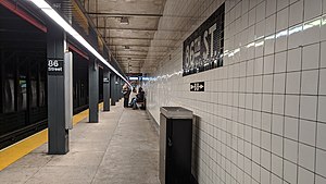
The platforms have no tile band, but mosaic name tablets reading "86TH ST." in white sans-serif lettering on a midnight blue background with a black border are present. There are also small "86" tile captions and directional signs in white lettering on a black background. Grey (previously blue) I-beam columns run along both platforms at regular intervals with alternating ones having the standard black station name plate in white lettering.
Exits[]
This station has three fare control areas, all of which are on the upper level. The full-time one at 86th Street is at the south end and has a turnstile bank, token booth, and three street stairs. Right inside fare control, there is a staircase going down to the lower level.[14] The station's other two entrances/exits are unstaffed. The one at 87th Street, at the center of the upper level, has a staircase connecting both platforms.[14] The third fare control area at 88th Street has three turnstiles and one gate, installed as part of the station's renovation. These replace the two HEET turnstiles and one exit-only turnstile[14] which were present beforehand.
- One stair, NW corner of Central Park West and West 86th Street[14]
- Two stairs, SW corner of Central Park West and West 86th Street[14]
- One stair, NW corner of Central Park West and West 87th Street[14]
- One stair, NW corner of Central Park West and West 88th Street[14]
References[]
- ^ "Glossary". Second Avenue Subway Supplemental Draft Environmental Impact Statement (SDEIS) (PDF). 1. Metropolitan Transportation Authority. March 4, 2003. pp. 1–2. Archived from the original (PDF) on February 26, 2021. Retrieved January 1, 2021.
- ^ Jump up to: a b "List of the 28 Stations on the New 8th Av. Line". The New York Times. September 10, 1932. p. 6. ISSN 0362-4331. Retrieved April 21, 2020.
- ^ "Station Developers' Information". Metropolitan Transportation Authority. Retrieved June 13, 2017.
- ^ "Facts and Figures: Annual Subway Ridership 2014–2019". Metropolitan Transportation Authority. 2020. Retrieved May 26, 2020.
- ^ Jump up to: a b "Facts and Figures: Annual Subway Ridership 2014–2019". Metropolitan Transportation Authority. 2020. Retrieved May 26, 2020.
- ^ Crowell, Paul (September 10, 1932). "Gay Midnight Crowd Rides First Trains In The New Subway: Throngs at Station an Hour Before Time, Rush Turnstiles When Chains are Dropped" (PDF). New York Times. Retrieved November 8, 2015.
- ^ Duffus, R. l (September 9, 1932). "NEW LINE FIRST UNIT IN CITY-WIDE SYSTEM; 8th Av. Tube to Ease West Side Congestion at Once -- Branches to Link 4 Boroughs Later. LAST WORD IN SUBWAYS Run From 207th to Chambers St. Cut to 33 Minutes -- 42d St. Has World's Largest Station. COST HAS BEEN $191,200,000 Years of Digging Up City Streets, Tunneling Rock and Building Road Finally Brought to Completion". The New York Times. p. 12. ISSN 0362-4331. Retrieved August 3, 2017.
- ^ "MTA Will Completely Close 30 Subway Stations For Months-Long "Revamp"". Gothamist. January 8, 2016. Archived from the original on August 1, 2016. Retrieved July 18, 2016.
- ^ "MTAStations" (PDF). governor.ny.gov. Government of the State of New York. Retrieved July 18, 2016.
- ^ "Enhanced Stations Initiative Program; Contract A·36622C (Package 3) for Design & Construction at 72nd Street, 86th Street, Cathedral Parkway (110th Street), and 163rd Street - Amsterdam Avenue Stations on the 8th Avenue Line (IND), Manhattan" (PDF). Metropolitan Transportation Authority. June 1, 2017. Retrieved July 27, 2017.
- ^ "New York City Transit and Bus Committee Meeting" (PDF). Metropolitan Transportation Authority. October 23, 2017. p. 131. Archived from the original (PDF) on October 31, 2017. Retrieved November 9, 2017.
- ^ Warerkar, Tanay (February 19, 2018). "MTA will shutter 4 Upper Manhattan subway stations for repairs". Curbed NY. Retrieved February 20, 2018.
- ^ Dougherty, Peter (2006) [2002]. Tracks of the New York City Subway 2006 (3rd ed.). Dougherty. OCLC 49777633 – via Google Books.
- ^ Jump up to: a b c d e f g "MTA Neighborhood Maps: Upper West Side" (PDF). mta.info. Metropolitan Transportation Authority. 2015. Retrieved December 30, 2016.
External links[]
| Wikimedia Commons has media related to 86th Street (IND Eighth Avenue Line). |
- nycsubway.org — IND 8th Avenue: 86th Street Archived May 11, 2012, at the Wayback Machine
- Station Reporter — B Train
- Station Reporter — C Train
- The Subway Nut — 86th Street Pictures Archived June 29, 2017, at the Wayback Machine
- 86th Street entrance from Google Maps Street View
- 87th Street exit only stairs from Google Maps Street View
- 88th Street entrance from Google Maps Street View
- Platform from Google Maps Street View
| show Central Park |
|---|
- IND Eighth Avenue Line stations
- Eighth Avenue (Manhattan)
- New York City Subway stations in Manhattan
- New York City Subway stations located underground
- Railway stations in the United States opened in 1932
- Upper West Side
- Central Park
- 1932 establishments in New York (state)