Broad Channel station
Broad Channel | ||||||||||||||||||||||||||||||||||||||||||||||||||||||||||||||||||||||||||||||||||||||||||||||||||||||||||||||||||||||||||||||||||||||||||||||||||||||||||||||||||||||||||||||||||||||||||||||||||||||
|---|---|---|---|---|---|---|---|---|---|---|---|---|---|---|---|---|---|---|---|---|---|---|---|---|---|---|---|---|---|---|---|---|---|---|---|---|---|---|---|---|---|---|---|---|---|---|---|---|---|---|---|---|---|---|---|---|---|---|---|---|---|---|---|---|---|---|---|---|---|---|---|---|---|---|---|---|---|---|---|---|---|---|---|---|---|---|---|---|---|---|---|---|---|---|---|---|---|---|---|---|---|---|---|---|---|---|---|---|---|---|---|---|---|---|---|---|---|---|---|---|---|---|---|---|---|---|---|---|---|---|---|---|---|---|---|---|---|---|---|---|---|---|---|---|---|---|---|---|---|---|---|---|---|---|---|---|---|---|---|---|---|---|---|---|---|---|---|---|---|---|---|---|---|---|---|---|---|---|---|---|---|---|---|---|---|---|---|---|---|---|---|---|---|---|---|---|---|---|
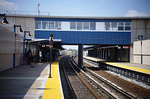 Broad Channel station after the post-Hurricane Sandy renovation | ||||||||||||||||||||||||||||||||||||||||||||||||||||||||||||||||||||||||||||||||||||||||||||||||||||||||||||||||||||||||||||||||||||||||||||||||||||||||||||||||||||||||||||||||||||||||||||||||||||||
| Station statistics | ||||||||||||||||||||||||||||||||||||||||||||||||||||||||||||||||||||||||||||||||||||||||||||||||||||||||||||||||||||||||||||||||||||||||||||||||||||||||||||||||||||||||||||||||||||||||||||||||||||||
| Address | Noel Road & West Road Queens, NY 11693 | |||||||||||||||||||||||||||||||||||||||||||||||||||||||||||||||||||||||||||||||||||||||||||||||||||||||||||||||||||||||||||||||||||||||||||||||||||||||||||||||||||||||||||||||||||||||||||||||||||||
| Borough | Queens | |||||||||||||||||||||||||||||||||||||||||||||||||||||||||||||||||||||||||||||||||||||||||||||||||||||||||||||||||||||||||||||||||||||||||||||||||||||||||||||||||||||||||||||||||||||||||||||||||||||
| Locale | Broad Channel | |||||||||||||||||||||||||||||||||||||||||||||||||||||||||||||||||||||||||||||||||||||||||||||||||||||||||||||||||||||||||||||||||||||||||||||||||||||||||||||||||||||||||||||||||||||||||||||||||||||
| Coordinates | 40°36′31″N 73°48′58″W / 40.608618°N 73.816°WCoordinates: 40°36′31″N 73°48′58″W / 40.608618°N 73.816°W | |||||||||||||||||||||||||||||||||||||||||||||||||||||||||||||||||||||||||||||||||||||||||||||||||||||||||||||||||||||||||||||||||||||||||||||||||||||||||||||||||||||||||||||||||||||||||||||||||||||
| Division | B (IND, formerly LIRR Rockaway Beach Branch)[1] | |||||||||||||||||||||||||||||||||||||||||||||||||||||||||||||||||||||||||||||||||||||||||||||||||||||||||||||||||||||||||||||||||||||||||||||||||||||||||||||||||||||||||||||||||||||||||||||||||||||
| Line | IND Rockaway Line | |||||||||||||||||||||||||||||||||||||||||||||||||||||||||||||||||||||||||||||||||||||||||||||||||||||||||||||||||||||||||||||||||||||||||||||||||||||||||||||||||||||||||||||||||||||||||||||||||||||
| Services | A S | |||||||||||||||||||||||||||||||||||||||||||||||||||||||||||||||||||||||||||||||||||||||||||||||||||||||||||||||||||||||||||||||||||||||||||||||||||||||||||||||||||||||||||||||||||||||||||||||||||||
| Transit | ||||||||||||||||||||||||||||||||||||||||||||||||||||||||||||||||||||||||||||||||||||||||||||||||||||||||||||||||||||||||||||||||||||||||||||||||||||||||||||||||||||||||||||||||||||||||||||||||||||||
| Structure | At-grade | |||||||||||||||||||||||||||||||||||||||||||||||||||||||||||||||||||||||||||||||||||||||||||||||||||||||||||||||||||||||||||||||||||||||||||||||||||||||||||||||||||||||||||||||||||||||||||||||||||||
| Platforms | 2 side platforms | |||||||||||||||||||||||||||||||||||||||||||||||||||||||||||||||||||||||||||||||||||||||||||||||||||||||||||||||||||||||||||||||||||||||||||||||||||||||||||||||||||||||||||||||||||||||||||||||||||||
| Tracks | 2 | |||||||||||||||||||||||||||||||||||||||||||||||||||||||||||||||||||||||||||||||||||||||||||||||||||||||||||||||||||||||||||||||||||||||||||||||||||||||||||||||||||||||||||||||||||||||||||||||||||||
| Other information | ||||||||||||||||||||||||||||||||||||||||||||||||||||||||||||||||||||||||||||||||||||||||||||||||||||||||||||||||||||||||||||||||||||||||||||||||||||||||||||||||||||||||||||||||||||||||||||||||||||||
| Opened | 1880 (LIRR station)[2] | |||||||||||||||||||||||||||||||||||||||||||||||||||||||||||||||||||||||||||||||||||||||||||||||||||||||||||||||||||||||||||||||||||||||||||||||||||||||||||||||||||||||||||||||||||||||||||||||||||||
| Closed | 1950 (LIRR station) | |||||||||||||||||||||||||||||||||||||||||||||||||||||||||||||||||||||||||||||||||||||||||||||||||||||||||||||||||||||||||||||||||||||||||||||||||||||||||||||||||||||||||||||||||||||||||||||||||||||
| Rebuilt | June 28, 1956 (as a Subway station) | |||||||||||||||||||||||||||||||||||||||||||||||||||||||||||||||||||||||||||||||||||||||||||||||||||||||||||||||||||||||||||||||||||||||||||||||||||||||||||||||||||||||||||||||||||||||||||||||||||||
| Station code | 199[3] | |||||||||||||||||||||||||||||||||||||||||||||||||||||||||||||||||||||||||||||||||||||||||||||||||||||||||||||||||||||||||||||||||||||||||||||||||||||||||||||||||||||||||||||||||||||||||||||||||||||
| Accessibility | Same-platform wheelchair transfer available | |||||||||||||||||||||||||||||||||||||||||||||||||||||||||||||||||||||||||||||||||||||||||||||||||||||||||||||||||||||||||||||||||||||||||||||||||||||||||||||||||||||||||||||||||||||||||||||||||||||
| Opposite- direction transfer | Yes | |||||||||||||||||||||||||||||||||||||||||||||||||||||||||||||||||||||||||||||||||||||||||||||||||||||||||||||||||||||||||||||||||||||||||||||||||||||||||||||||||||||||||||||||||||||||||||||||||||||
| Traffic | ||||||||||||||||||||||||||||||||||||||||||||||||||||||||||||||||||||||||||||||||||||||||||||||||||||||||||||||||||||||||||||||||||||||||||||||||||||||||||||||||||||||||||||||||||||||||||||||||||||||
| 2019 | 90,358[4] | |||||||||||||||||||||||||||||||||||||||||||||||||||||||||||||||||||||||||||||||||||||||||||||||||||||||||||||||||||||||||||||||||||||||||||||||||||||||||||||||||||||||||||||||||||||||||||||||||||||
| Rank | 423 out of 424[4] | |||||||||||||||||||||||||||||||||||||||||||||||||||||||||||||||||||||||||||||||||||||||||||||||||||||||||||||||||||||||||||||||||||||||||||||||||||||||||||||||||||||||||||||||||||||||||||||||||||||
| Station succession | ||||||||||||||||||||||||||||||||||||||||||||||||||||||||||||||||||||||||||||||||||||||||||||||||||||||||||||||||||||||||||||||||||||||||||||||||||||||||||||||||||||||||||||||||||||||||||||||||||||||
| Next north | Howard Beach–JFK Airport: A (Terminal): S | |||||||||||||||||||||||||||||||||||||||||||||||||||||||||||||||||||||||||||||||||||||||||||||||||||||||||||||||||||||||||||||||||||||||||||||||||||||||||||||||||||||||||||||||||||||||||||||||||||||
| Next south | Beach 67th Street (Far Rockaway): A Beach 90th Street (Rockaway Park): A | |||||||||||||||||||||||||||||||||||||||||||||||||||||||||||||||||||||||||||||||||||||||||||||||||||||||||||||||||||||||||||||||||||||||||||||||||||||||||||||||||||||||||||||||||||||||||||||||||||||
| ||||||||||||||||||||||||||||||||||||||||||||||||||||||||||||||||||||||||||||||||||||||||||||||||||||||||||||||||||||||||||||||||||||||||||||||||||||||||||||||||||||||||||||||||||||||||||||||||||||||
| ||||||||||||||||||||||||||||||||||||||||||||||||||||||||||||||||||||||||||||||||||||||||||||||||||||||||||||||||||||||||||||||||||||||||||||||||||||||||||||||||||||||||||||||||||||||||||||||||||||||
| ||||||||||||||||||||||||||||||||||||||||||||||||||||||||||||||||||||||||||||||||||||||||||||||||||||||||||||||||||||||||||||||||||||||||||||||||||||||||||||||||||||||||||||||||||||||||||||||||||||||
| ||||||||||||||||||||||||||||||||||||||||||||||||||||||||||||||||||||||||||||||||||||||||||||||||||||||||||||||||||||||||||||||||||||||||||||||||||||||||||||||||||||||||||||||||||||||||||||||||||||||
| ||||||||||||||||||||||||||||||||||||||||||||||||||||||||||||||||||||||||||||||||||||||||||||||||||||||||||||||||||||||||||||||||||||||||||||||||||||||||||||||||||||||||||||||||||||||||||||||||||||||


Broad Channel is a station on the IND Rockaway Line of the New York City Subway, located in the neighborhood of the same name at Noel and West Roads in the borough of Queens. It is served by the A train and the Rockaway Park Shuttle at all times, the latter of which originates/terminates here.
Broad Channel originally opened in 1880 as a Long Island Railroad station. The LIRR discontinued service in 1950 after a fire on the trestle across Jamaica Bay, to the station's north. The station reopened June 28, 1956, as a subway station.
Broad Channel is the only subway station serving the island of Broad Channel, which is located in Jamaica Bay and only has about 3,000 residents. Thus it is the second least-used in the subway as of 2019. However, this station is the only transfer point for riders traveling between Brooklyn and Manhattan (which the A train travels to) and the four other stations served by the Rockaway Park Shuttle.
North of this station, two additional tracks are located within the right-of-way. One of the tracks is used to allow for Rockaway Park Shuttle trains to relay and to go back into service to the Rockaways, while the other track is called the Far Rockaway Test Track. The latter of the two tracks is used to test new subway cars to make sure that they are ready for acceptance into New York City Transit's fleet of subway cars.
History[]
The station originally opened in 1880 as a New York, Woodhaven and Rockaway Railroad station (although some sources claim it opened in June 1881) and was acquired by the Long Island Rail Road, to become a station on the Rockaway Beach Branch.[5]
As a Long Island Rail Road station it served as one of two junctions between the Far Rockaway and Rockaway Beach Branches. The other junction was at Hammels Station, although it was originally a junction for the Far Rockaway Branch and the Ocean Electric Railway. Hammels is now located where Hammels Wye is. Wooden shelter sheds were added to the station in 1921 and 1923.[5] A fire on the trestle between this station and another one known as The Raunt, located to the north, forced the closure of both stations on May 23, 1950, as well as the entire Jamaica Bay trestle which stretches from Howard Beach to Hammels Wye.[6][7][8]
By October 3, 1955, the Rockaway Beach Branch south of Ozone Park, and all of the Far Rockaway Branch west of Far Rockaway were purchased by the New York City Transit Authority. The Broad Channel station was completely reconstructed (as were the Howard Beach and Far Rockaway stations) with new concrete platforms, and a new station house. The contract for the new station was approved in December 1954.[9][10][11][12] The station opened to subway service on June 28, 1956.[8]
The station and the adjacent segment of the Rockaway Line suffered serious damage during Hurricane Sandy in 2012, and was out of service for several months. Due to its location in the middle of Jamaica Bay, the station was filled with debris, with its trackbed damaged.[13][14] During its temporary closure, the station received new ADA-tactile strips, platform edge rubbing boards, and cosmetic and mechanical work. Service was restored to the station on May 30, 2013, and to celebrate the re-opening, a vintage R1 subway car formed the first train.[15] In 2018, a two-phase program of flood mitigation work along the Hammels Wye required further service disruptions. The first phase, from April 9 to May 18, suspended rush-hour A trips to Rockaway Park. The second phase, which began on July 1, rerouted all Far Rockaway A service to Rockaway Park until September 3. In both phases, the shuttle ran from Rockaway Park to Far Rockaway, skipping Broad Channel.[16]
Station layout[]
| M | Mezzanine | Crossover between platforms |
| P Platform level |
Side platform | |
| Northbound | ← ← | |
| Southbound | | |
| Side platform | ||
| G | Street level | Exit/Entrance, station house and agent, fare control, MetroCard machines |

This station has two tracks and two side platforms, each measuring 12 feet (3.7 m) wide and over 660 feet (200 m) long.[9] The northern parts of the platforms are sheltered with canopies and windscreens.[9] The station is one of two New York City Subway stations located on its own island, the other being the Roosevelt Island station in Manhattan, serving the F and <F> trains.[17]
Exit[]
A station house is located above both platforms, containing a crossover, waiting area and fare control.[9][18] The single street staircase outside of fare control goes down to West Road by the intersection of Noel Road next to the Rockaway-bound platform.[9][19][20]: 9 [note 1] This platform also has a set of exit-only turnstiles leading directly to this staircase so riders exiting the station on this side do not have to go through the station house. The station house is heated, while the platforms feature passenger-activated heaters;[22]: 35 these heaters, and the doors separating the station house and staircases, were not originally part of the station.[23][24] The station house used to have 1950s-era signage at its front entrance reading "SUBWAY", but now only has modern MTA entrance signs.[20]
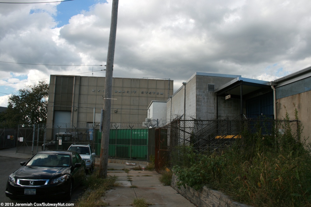
At the north end of the station is a power substation, located at West Road and East 6th Road adjacent to the Rockaway-bound platform.[9][18][20] A second exit-only staircase is located here, but is closed.[18][25]
Track layout[]

Just to the north, the Rockaway Line gains two extra non-revenue tracks straddling the two revenue tracks.[26] The western track is a test track, installed in 2001 and called the Far Rockaway Test Track,[27][28][29]: 13-29–13-32 [30]: 1–3 [31]: 30–31 while the eastern track is used to relay shuttle trains.[22][32] The western track extends around 10,000 feet (3,000 m) or nearly 2 miles,[27] while the eastern track is long enough for one full-length train (600 feet (180 m)) and ends at a bumper block.[26] The test track was installed in 2001 by New York City Transit's Maintenance of Way Department to ensure that new cars have undergone necessary acceleration and braking tests before being put into revenue service. This was because NYCT needed to recover a greater amount of braking energy and reduce power demand peaks with the introduction of AC-motored cars with the capability for regenerative braking. A kinetic energy storage system with KESS technology was installed, and as a result, the voltage regulation of the track improved. The system provides voltage support to the revenue tracks as well as reinforcing the voltage of the test track during the testing of new trains.[28]
Continuing north, the Rockaway Line crosses Jamaica Bay before reaching Howard Beach; the distance of 3.5 miles (5.6 km) between the two stations is the longest between any two in the New York City Subway system.[27] To the south, the Rockaway Line continues to the Rockaway peninsula, crossing two bridges: a fixed span between Broad Channel and Subway Island, and a swing span between Subway Island and the Rockaway peninsula. On the peninsula, the line splits at a flying junction named Hammels Wye to allow service to both Far Rockaway–Mott Avenue and Rockaway Park–Beach 116th Street.[22][26] Punch boxes are located at the ends of both platforms, to allow train operators to select the correct route. The switches are then accordingly switched by the local tower operator.[26]: xix [33]
Ridership[]

Broad Channel is a small island with fewer than 3,000 residents,[34] and as a result, it has historically been one of the least-used stations in the system. In 1985, the station had only 224 paying daily riders on a typical weekday not counting farebeaters (people not paying their fare) making it one of the least used stations in the system.[35] The station has the second lowest ridership in the subway system as of 2019, with 90,358 annual riders.[4] However, it is the only transfer point between the A train and the Rockaway Park Shuttle, and some 2,700 daily riders use it in this capacity.[22][23] As a result, the platforms are sometimes packed.[36]
Nearby points of interest include a visitor center and trails for the Gateway National Recreation Area's Jamaica Bay Wildlife Refuge.[19][20] The Refuge is one of the most significant bird sanctuaries in the Northeastern United States, and it is home to more than 330 bird species, making it one of the most ideal places in New York City to observe migrating birds. The visitor center is the start of many guided tours of the refuge and it is home to exhibits that discuss the history of Jamaica Bay, the wide array of wildlife that can be found there, and the impact of human activity.[37]
Gallery[]
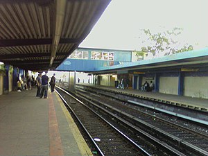
A view of the northbound platform at Broad Channel facing to the south, prior to renovations
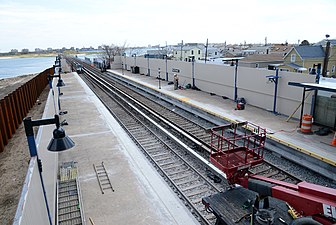
A view of the southern end of the station during the renovation of the line
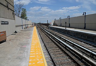
A view of the southbound platform facing to the north, the renovation almost complete
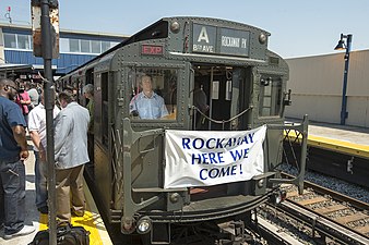
A vintage R1 subway car leading the first trip onto the Rockaway Line on May 30, 2013 after having been closed due to damage from Hurricane Sandy


Notes[]
References[]
- ^ "Glossary". Second Avenue Subway Supplemental Draft Environmental Impact Statement (SDEIS) (PDF). 1. Metropolitan Transportation Authority. March 4, 2003. pp. 1–2. Archived from the original (PDF) on February 26, 2021. Retrieved January 1, 2021.
- ^ Long Island Rail Road History Website — The NY, Woodhaven and Rockaway RR
- ^ "Station Developers' Information". Metropolitan Transportation Authority. Retrieved June 13, 2017.
- ^ a b "Facts and Figures: Annual Subway Ridership 2014–2019". Metropolitan Transportation Authority. 2020. Retrieved May 26, 2020.
- ^ a b "Long Island Station History". www.trainsarefun.com. Archived from the original on May 26, 2017. Retrieved June 8, 2017.
- ^ "L.I.R.R. Proposes Junking Trestle Ruined by Fire". Brooklyn Daily Eagle. May 31, 1950. p. 4. Retrieved September 22, 2015 – via Newspapers.com.
- ^ Bresiger, Gregory (July 18, 2012). "The Trains Stopped Running Here 50 Years Ago". qgazette.com. Queens Gazette. Archived from the original on July 4, 2015. Retrieved July 3, 2015.
- ^ a b Freeman, Ira Henry (June 28, 1956). "Rockaway Trains to Operate Today" (PDF). The New York Times. Retrieved June 29, 2015.
- ^ a b c d e f "$7,000,000 Signal Job To Be Let In February: City Approves $1,000,000 Contracts For Station And Sub-Station in Broad Channel And For The Rehabilitation Of The Liberty Avenue Line". Wave of Long Island. Fultonhistory.com. December 23, 1954. p. 1. Retrieved July 22, 2016.
- ^ "$7,000,000 Signal Job To Be Let In February: City Approves $1,000,000 Contracts For Station And Sub-Station in Broad Channel And For The Rehabilitation Of The Liberty Avenue Line" (PDF). Wave of Long Island. Fultonhistory.com. December 23, 1954. p. 7. Retrieved July 22, 2016.
- ^ "New Station Set At Howard Beach" (PDF). The New York Times. November 11, 1954. Retrieved June 29, 2015.
- ^ "New Look In Transit: Modernistic Station And Drawbridge". Wave of Long Island. Fultonhistory.com. December 2, 1954. p. 1. Retrieved August 16, 2016.
- ^ "Rebuilding the Rockaways After Hurricane Sandy". mta.info. Metropolitan Transportation Authority. Archived from the original on November 29, 2012. Retrieved November 18, 2012.
- ^ Chaban, Matt (November 11, 2012). "Broad Channel Crossing Must Be Rebuilt, Leaving Rockaways Without A-Train for Months or Longer". New York Observer. Retrieved July 22, 2016.
- ^ "A Train Service Restored to Rockaways". Metropolitan Transportation Authority. May 30, 2013.
- ^ "Train Change: A/ Shuttle Service to be Impacted Starting in April". THE ROCKAWAY TIMES - First and Free. March 8, 2018. Retrieved March 30, 2018.
- ^ "Subway Map" (PDF). Metropolitan Transportation Authority. September 2021. Retrieved September 17, 2021.
- ^ a b c New York City Transit Authority (November 1, 1954). "Architectural Drawing of Broad Channel Station: IND Rockaway Line". New York Transit Museum. Retrieved August 25, 2016.
- ^ a b "MTA Neighborhood Maps: The Rockaways" (PDF). mta.info. Metropolitan Transportation Authority. 2015. Retrieved July 6, 2015.
- ^ a b c d "Broad Channel: a future land use proposal". New York City Department of City Planning. August 1962. Retrieved July 22, 2016.
- ^ "Shell Greater New York City (Eastern Section). To and Through Manhattan". Shell Oil Company. 1956. Retrieved June 8, 2017.
- ^ a b c d Review of the A and C Lines (PDF) (Report). Metropolitan Transportation Authority. December 11, 2015. Archived from the original (PDF) on February 3, 2020. Retrieved January 19, 2016.
- ^ a b "Zero Weather, Token Limit Accelerate Subway Gripes". Wave of Long Island. Fultonhistory.com. January 11, 1968. p. 1. Retrieved July 22, 2016.
- ^ "Zero Weather, Token Limit Accelerate Subway Gripes" (PDF). Wave of Long Island. Fultonhistory.com. January 11, 1968. p. 4. Retrieved July 22, 2016.
- ^ Cox, Jeremiah (September 13, 2013). "Outside the substation and former exit only staircase". subwaynut.com. Retrieved June 8, 2017.
- ^ a b c d Dougherty, Peter (2020). Tracks of the New York City Subway 2020 (16th ed.). Dougherty. OCLC 1056711733.
- ^ a b c "Rebuilding the Rockaways After Hurricane Sandy: The Recovery". Metropolitan Transportation Authority. May 16, 2013. Retrieved July 27, 2016.
- ^ a b Tarrant, Colin (April 1, 2004). "Kinetic energy storage wins acceptance". Railway Gazette International. Retrieved July 27, 2016.
- ^ "EPRI-DOE Handbook of Energy Storage for Transmission & Distribution Applications: Final Report, December 2003" (PDF). Electric Power Research Institute, United States Department of Energy. December 2003. Retrieved July 27, 2016.
- ^ "BATTERY POWER SYSTEM FOR TRACKSIDE ENERGY STORGE Final Repor" (PDF). New York State Energy Research and Development Authority, Kawasaki Heavy Industries Rolling Stock Company, Kawasaki Heavy Industries. October 2010. Retrieved July 27, 2016.
- ^ "Handbook of Energy Storage for Transmission or Distribution Applications: Technical Update, December 2002" (PDF). Electric Power Research Institute. December 2002. Retrieved July 27, 2016.
- ^ "M31878 INSTALL RELAY TRACK BROAD CHANNEL STATION ROCKAWAY LINE $5M - $10M". mta.nyc.ny.us. New York City Transit. February 2, 1997. Archived from the original on February 2, 1997. Retrieved September 18, 2016.
- ^ Rosenfeld, Robbie (May 30, 2013). "Photo of punch box on northbound platform". nycsubway.org. Retrieved August 27, 2016.
- ^ Khan, Kulsoom (March 31, 2016). "Broad Channel". Queens Tribune. Archived from the original on February 3, 2017. Retrieved July 22, 2016.
- ^ Levine, Richard (November 5, 1986). "COLUMN ONE: TRANSPORT". The New York Times. ISSN 0362-4331. Retrieved October 2, 2016.
- ^ "Safest and riskiest areas of New York's subway system revealed in Daily News investigation". New York Daily News. June 22, 2014. Retrieved March 18, 2016.
- ^ Productions, Mixit. "Jamaica Bay Wildlife Refuge". www.nyharborparks.org. Retrieved June 8, 2017.
External links[]
| Wikimedia Commons has media related to Broad Channel station. |
- nycsubway.org – IND Rockaway: Broad Channel
- Station Reporter — Rockaway Park Shuttle
- The Subway Nut - Broad Channel Pictures Archived July 6, 2020, at the Wayback Machine
- Entrance from Google Maps Street View
- Platforms from Google Maps Street View
| Rockaway Line | |||||
|---|---|---|---|---|---|
| |||||
- IND Rockaway Line stations
- New York City Subway stations in Queens, New York
- New York City Subway terminals
- New York City Subway stations located at-grade
- New York City Subway stations located aboveground
- Railway stations in the United States opened in 1956
- 1956 establishments in New York City