Beach 44th Street station
Beach 44 Street | ||||||||||||||||||||||||||||||||||||||||||||||||||||||||||||||||||||
|---|---|---|---|---|---|---|---|---|---|---|---|---|---|---|---|---|---|---|---|---|---|---|---|---|---|---|---|---|---|---|---|---|---|---|---|---|---|---|---|---|---|---|---|---|---|---|---|---|---|---|---|---|---|---|---|---|---|---|---|---|---|---|---|---|---|---|---|---|
 Southbound platform | ||||||||||||||||||||||||||||||||||||||||||||||||||||||||||||||||||||
| Station statistics | ||||||||||||||||||||||||||||||||||||||||||||||||||||||||||||||||||||
| Address | Beach 44th Street & Rockaway Freeway Queens, NY 11691 | |||||||||||||||||||||||||||||||||||||||||||||||||||||||||||||||||||
| Borough | Queens | |||||||||||||||||||||||||||||||||||||||||||||||||||||||||||||||||||
| Locale | Edgemere | |||||||||||||||||||||||||||||||||||||||||||||||||||||||||||||||||||
| Coordinates | 40°35′35″N 73°46′34″W / 40.592928°N 73.775986°WCoordinates: 40°35′35″N 73°46′34″W / 40.592928°N 73.775986°W | |||||||||||||||||||||||||||||||||||||||||||||||||||||||||||||||||||
| Division | B (IND, formerly LIRR Far Rockaway Branch)[1] | |||||||||||||||||||||||||||||||||||||||||||||||||||||||||||||||||||
| Line | IND Rockaway Line | |||||||||||||||||||||||||||||||||||||||||||||||||||||||||||||||||||
| Services | A | |||||||||||||||||||||||||||||||||||||||||||||||||||||||||||||||||||
| Transit | ||||||||||||||||||||||||||||||||||||||||||||||||||||||||||||||||||||
| Structure | Elevated | |||||||||||||||||||||||||||||||||||||||||||||||||||||||||||||||||||
| Platforms | 2 side platforms | |||||||||||||||||||||||||||||||||||||||||||||||||||||||||||||||||||
| Tracks | 2 | |||||||||||||||||||||||||||||||||||||||||||||||||||||||||||||||||||
| Other information | ||||||||||||||||||||||||||||||||||||||||||||||||||||||||||||||||||||
| Opened | 1922 (LIRR station) | |||||||||||||||||||||||||||||||||||||||||||||||||||||||||||||||||||
| Rebuilt | June 28, 1956 (as a Subway station) | |||||||||||||||||||||||||||||||||||||||||||||||||||||||||||||||||||
| Station code | 206[2] | |||||||||||||||||||||||||||||||||||||||||||||||||||||||||||||||||||
| Opposite- direction transfer | Yes | |||||||||||||||||||||||||||||||||||||||||||||||||||||||||||||||||||
| Former/other names | Beach 44th Street–Frank Avenue | |||||||||||||||||||||||||||||||||||||||||||||||||||||||||||||||||||
| Traffic | ||||||||||||||||||||||||||||||||||||||||||||||||||||||||||||||||||||
| 2019 | 215,701[4] | |||||||||||||||||||||||||||||||||||||||||||||||||||||||||||||||||||
| Rank | 421 out of 424[4] | |||||||||||||||||||||||||||||||||||||||||||||||||||||||||||||||||||
| Station succession | ||||||||||||||||||||||||||||||||||||||||||||||||||||||||||||||||||||
| Next west | Beach 60th Street: A | |||||||||||||||||||||||||||||||||||||||||||||||||||||||||||||||||||
| Next east | Beach 36th Street: A | |||||||||||||||||||||||||||||||||||||||||||||||||||||||||||||||||||
| ||||||||||||||||||||||||||||||||||||||||||||||||||||||||||||||||||||
| ||||||||||||||||||||||||||||||||||||||||||||||||||||||||||||||||||||
| ||||||||||||||||||||||||||||||||||||||||||||||||||||||||||||||||||||
| ||||||||||||||||||||||||||||||||||||||||||||||||||||||||||||||||||||
| ||||||||||||||||||||||||||||||||||||||||||||||||||||||||||||||||||||


Beach 44th Street, signed as Beach 44th Street–Frank Avenue, is a station on the IND Rockaway Line of the New York City Subway. It is served by the A train at all times.
History[]

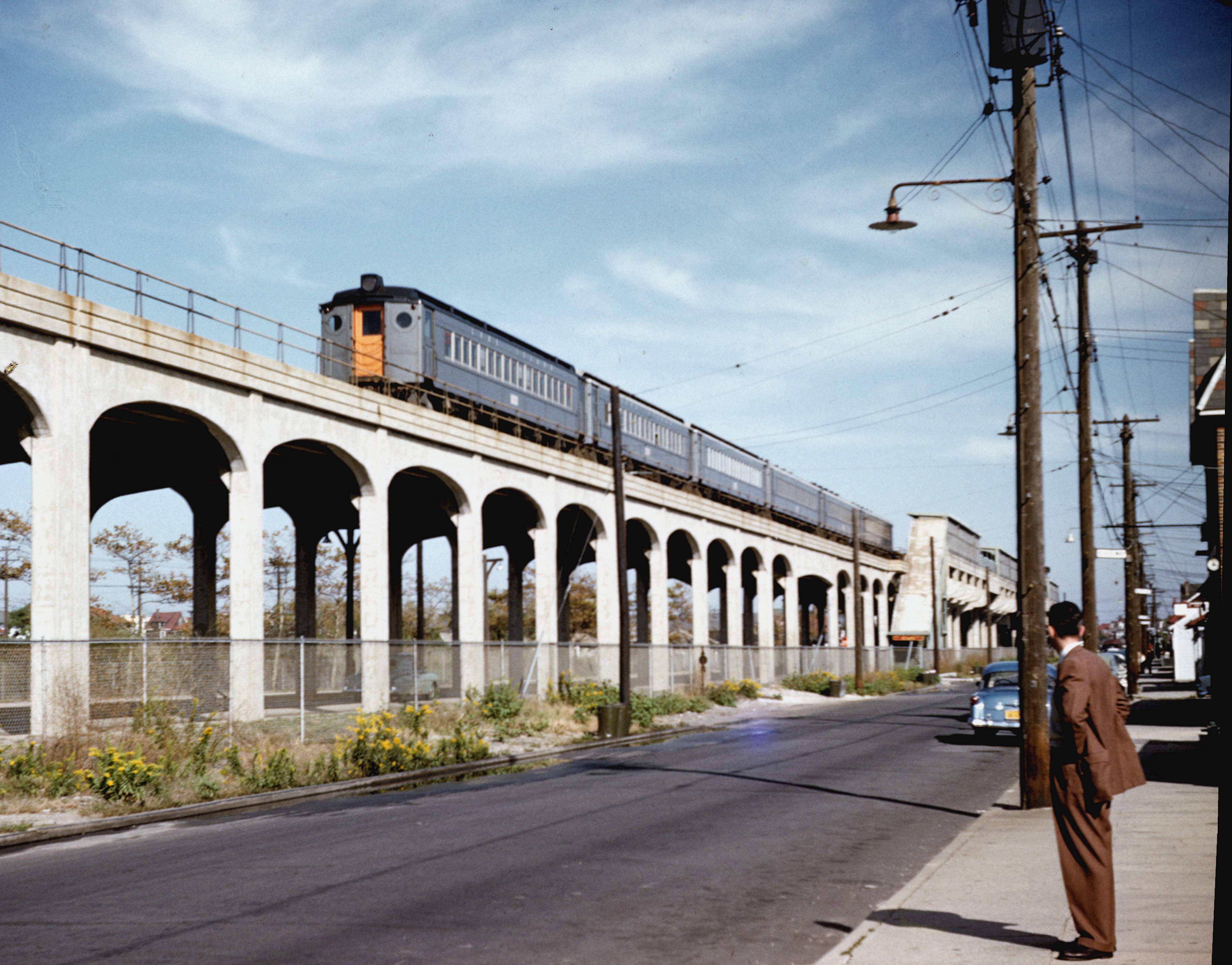
Beach 44th Street–Frank Avenue was originally a trolley stop of the Ocean Electric Railway, which used a former segment of the Long Island Rail Road's Far Rockaway Branch tracks, until it became a Long Island Railroad Station in 1922. The station was relocated 758 feet east of its former location between August 2 and August 23, 1940 as part of a grade crossing elimination project between Beach 44th Street and Beach 47th Street. The new elevated station was opened on April 10, 1942.[5][6]
The station was purchased by New York City on October 3, 1955, along with the rest of the Rockaway Beach Branch and Far Rockaway Branch west of Far Rockaway, after a fire on the line's crossing over Jamaica Bay in 1950.[7] Now operated by the New York City Transit Authority, it reopened as a subway station along the IND Rockaway Line on June 28, 1956.[7]
Station layout[]
| P Platform level |
Side platform | |
| Northbound | ← | |
| Southbound | | |
| Side platform | ||
| M | Mezzanine | Fare control, station agent, MetroCard machines |
| G | Street level | Exit/entrance |
There are two tracks and two side platforms.
Exits[]
This station has no closed exits, and the full-time fare control is at the middle of the platforms. Four stairs lead to the street, two on each western corner of Rockaway Freeway and Beach 44th Street.[8]
References[]
- ^ "Glossary". Second Avenue Subway Supplemental Draft Environmental Impact Statement (SDEIS) (PDF). 1. Metropolitan Transportation Authority. March 4, 2003. pp. 1–2. Archived from the original (PDF) on February 26, 2021. Retrieved January 1, 2021.
- ^ "Station Developers' Information". Metropolitan Transportation Authority. Retrieved June 13, 2017.
- ^ "Facts and Figures: Annual Subway Ridership 2014–2019". Metropolitan Transportation Authority. 2020. Retrieved May 26, 2020.
- ^ a b "Facts and Figures: Annual Subway Ridership 2014–2019". Metropolitan Transportation Authority. 2020. Retrieved May 26, 2020.
- ^ "Last Grade Crossing In Rockaways Ends" (PDF). The New York Times. April 11, 1942. Retrieved 30 June 2015.
- ^ "Pushes Grade Separation" (PDF). The New York Times. January 24, 1932. Retrieved June 30, 2015.
- ^ a b Freeman, Ira Henry (June 28, 1956). "Rockaway Trains to Operate Today" (PDF). The New York Times. Retrieved June 29, 2015.
- ^ "MTA Neighborhood Maps: The Rockaways" (PDF). mta.info. Metropolitan Transportation Authority. 2015. Retrieved July 6, 2015.
External links[]
| Wikimedia Commons has media related to Beach 44th Street (IND Rockaway Line). |
- nycsubway.org – IND Rockaway: Beach 44th Street-Frank Avenue
- Station Reporter — A Rockaway
- Frank Avenue Station, 1955 (Arrt's Arrchives)
- The Subway Nut — Beach 44th Street-Frank Avenue Pictures Archived 2017-06-15 at the Wayback Machine
- Beach 44th Street entrance from Google Maps Street View
- Platforms from Google Maps Street View
| Rockaway Line | |||||
|---|---|---|---|---|---|
| |||||
- IND Rockaway Line stations
- Rockaway, Queens
- New York City Subway stations in Queens, New York
- New York City Subway stations located aboveground
- Railway stations in the United States opened in 1956
- 1956 establishments in New York City
- Railway stations in the United States opened in 1922
- 1922 establishments in New York City