Beach 98th Street station
Beach 98 Street | ||||||||||||||||||||||||||||||||||||||||||||||||||||||||||||||||||||
|---|---|---|---|---|---|---|---|---|---|---|---|---|---|---|---|---|---|---|---|---|---|---|---|---|---|---|---|---|---|---|---|---|---|---|---|---|---|---|---|---|---|---|---|---|---|---|---|---|---|---|---|---|---|---|---|---|---|---|---|---|---|---|---|---|---|---|---|---|
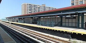 View of Rockaway Park-bound platform | ||||||||||||||||||||||||||||||||||||||||||||||||||||||||||||||||||||
| Station statistics | ||||||||||||||||||||||||||||||||||||||||||||||||||||||||||||||||||||
| Address | Beach 98th Street & Rockaway Freeway Queens, NY 11694 | |||||||||||||||||||||||||||||||||||||||||||||||||||||||||||||||||||
| Borough | Queens | |||||||||||||||||||||||||||||||||||||||||||||||||||||||||||||||||||
| Locale | Rockaway Beach | |||||||||||||||||||||||||||||||||||||||||||||||||||||||||||||||||||
| Coordinates | 40°35′08″N 73°49′13″W / 40.585441°N 73.820186°WCoordinates: 40°35′08″N 73°49′13″W / 40.585441°N 73.820186°W | |||||||||||||||||||||||||||||||||||||||||||||||||||||||||||||||||||
| Division | B (IND, formerly LIRR Rockaway Beach Branch)[1] | |||||||||||||||||||||||||||||||||||||||||||||||||||||||||||||||||||
| Line | IND Rockaway Line | |||||||||||||||||||||||||||||||||||||||||||||||||||||||||||||||||||
| Services | A S | |||||||||||||||||||||||||||||||||||||||||||||||||||||||||||||||||||
| Transit | ||||||||||||||||||||||||||||||||||||||||||||||||||||||||||||||||||||
| Structure | Elevated | |||||||||||||||||||||||||||||||||||||||||||||||||||||||||||||||||||
| Platforms | 2 side platforms | |||||||||||||||||||||||||||||||||||||||||||||||||||||||||||||||||||
| Tracks | 2 | |||||||||||||||||||||||||||||||||||||||||||||||||||||||||||||||||||
| Other information | ||||||||||||||||||||||||||||||||||||||||||||||||||||||||||||||||||||
| Opened | April 1903 (LIRR station) | |||||||||||||||||||||||||||||||||||||||||||||||||||||||||||||||||||
| Rebuilt | June 28, 1956 (as a Subway station) | |||||||||||||||||||||||||||||||||||||||||||||||||||||||||||||||||||
| Station code | 201[3] | |||||||||||||||||||||||||||||||||||||||||||||||||||||||||||||||||||
| Opposite- direction transfer | Yes | |||||||||||||||||||||||||||||||||||||||||||||||||||||||||||||||||||
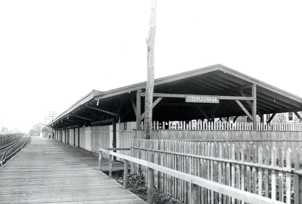
| Former/other names | Steeplechase (1903–May 15, 1933[2]) Playland Beach 98th Street–Playland | |||||||||||||||||||||||||||||||||||||||||||||||||||||||||||||||||||
| Traffic | ||||||||||||||||||||||||||||||||||||||||||||||||||||||||||||||||||||
| 2019 | 164,130[5] | |||||||||||||||||||||||||||||||||||||||||||||||||||||||||||||||||||
| Rank | 422 out of 424[5] | |||||||||||||||||||||||||||||||||||||||||||||||||||||||||||||||||||
| Station succession | ||||||||||||||||||||||||||||||||||||||||||||||||||||||||||||||||||||
| Next east | Beach 90th Street: A | |||||||||||||||||||||||||||||||||||||||||||||||||||||||||||||||||||
| Next west | Beach 105th Street: A | |||||||||||||||||||||||||||||||||||||||||||||||||||||||||||||||||||
| ||||||||||||||||||||||||||||||||||||||||||||||||||||||||||||||||||||
| ||||||||||||||||||||||||||||||||||||||||||||||||||||||||||||||||||||
| ||||||||||||||||||||||||||||||||||||||||||||||||||||||||||||||||||||
| ||||||||||||||||||||||||||||||||||||||||||||||||||||||||||||||||||||
| ||||||||||||||||||||||||||||||||||||||||||||||||||||||||||||||||||||


Beach 98th Street, signed as Beach 98th Street–Playland, is a station on the IND Rockaway Line of the New York City Subway. It is served by the Rockaway Park Shuttle at all times and ten daily rush-hour only A trains.
History[]
The station was originally built by the Long Island Rail Road in April 1903 as Steeplechase on the Rockaway Beach Branch, and was also a trolley stop of the Ocean Electric Railway. It was renamed Playland on May 15, 1933,[2] for the former Rockaways' Playland, which was closed in 1985. No trace of the park remains other than the station name. In 1942, the station was replaced with an elevated station, and was taken out of service on October 3, 1955 as part of its purchase by the New York City Transit Authority, which reopened it as a subway station on June 28, 1956.
Station layout[]
| P Platform level |
Side platform | |
| Southbound | ← ← | |
| Northbound | | |
| Side platform | ||
| M | Mezzanine | Fare control, station agent, MetroCard vending machines |
| G | Street level | Entrances/exits |

The station is built on a concrete viaduct. There are two tracks and two side platforms. New lights have been installed. Canopies, mezzanine, and side walls are similar to Beach 90th Street.
Exits[]
There is a crossunder to the tiled mezzanine. The southbound platform is longer than the northbound one, and had an exit at the north end of the Rockaway Park bound platform which has been removed. Outside of fare control, there are stairs to either eastern corner of Rockaway Freeway and Beach 99th Street.[6]
References[]
- ^ "Glossary". Second Avenue Subway Supplemental Draft Environmental Impact Statement (SDEIS) (PDF). 1. Metropolitan Transportation Authority. March 4, 2003. pp. 1–2. Archived from the original (PDF) on February 26, 2021. Retrieved January 1, 2021.
- ^ a b Baer, Christopher T. (April 2015). "A General Chronology of the Pennsylvania Railroad Company Its Predecessors and Successors and Its Historical Context: 1933" (PDF). Pennsylvania Railroad Technical Historical Society. p. 36. Retrieved December 7, 2015.
- ^ "Station Developers' Information". Metropolitan Transportation Authority. Retrieved June 13, 2017.
- ^ "Facts and Figures: Annual Subway Ridership 2014–2019". Metropolitan Transportation Authority. 2020. Retrieved May 26, 2020.
- ^ a b "Facts and Figures: Annual Subway Ridership 2014–2019". Metropolitan Transportation Authority. 2020. Retrieved May 26, 2020.
- ^ "MTA Neighborhood Maps: The Rockaways" (PDF). mta.info. Metropolitan Transportation Authority. 2015. Retrieved July 6, 2015.
External links[]
| Wikimedia Commons has media related to Beach 98th Street station. |
- nycsubway.org – IND Rockaway: Beach 98th Street/Playland
- Station Reporter — Rockaway Park Shuttle
- Steeplechase Station (Arrt's Arrchives)
- The Subway Nut — Beach 98th Street – Playland Pictures Archived 2018-01-05 at the Wayback Machine
- Beach 98th Street entrance from Google Maps Street View
- Platform level from Google Maps Street View
- Mezzanine from Google Maps Street View
| Rockaway Line | |||||
|---|---|---|---|---|---|
| |||||
- IND Rockaway Line stations
- Rockaway, Queens
- New York City Subway stations in Queens, New York
- New York City Subway stations located aboveground
- Railway stations in the United States opened in 1956
- 1956 establishments in New York City