June 2020 Pennsylvania–New Jersey derecho
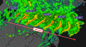 A radar composite image of the June 2020 Pennsylvania–New Jersey derecho. | |
| Date(s) | Wednesday, June 3, 2020 |
|---|---|
| Peak wind gust (measured) | 93 mph (150 km/h; 41.6 m/s) (Beach Haven, New Jersey) |
| Fatalities | 4 |
The June 2020 Pennsylvania–New Jersey derecho took place in the mid-Atlantic on June 3, 2020, between mid-morning and mid-day. It mainly affected southeastern Pennsylvania and southern New Jersey. It resulted in four fatalities[1] and about 575,000 people were left without power in the area. Structures, trees and power lines were also damaged by the powerful winds.[2]
Storm overview[]
A mesoscale convective system developed just south of Lake Erie in the early morning hours of the June 3. Damaging winds in excess of 60 miles per hour (97 km/h) were sporadic in western and central Pennsylvania, but as the MCS moved into increasingly unstable air in the eastern part of the state before noon, wind damage became more numerous and widespread.[1] The National Weather Service warned of an "extremely dangerous situation" as the squall line moved over the Philadelphia metro area and into New Jersey. According to the National Weather Service, the squall line met the criteria of a derecho, a fast-moving line of violent storms that produces widespread damage along its path. About 250 reports of wind damage were associated with the storms, with the highest measured wind gust being 93 mph in Beach Haven, New Jersey.[3]
The Storm Prediction Center highlighted much of eastern Pennsylvania and the entire state of New Jersey in an enhanced risk for severe thunderstorms. Morning storms over the Great Lakes intensified as they encountered warm, humid air over the East Coast. The environment over southern Pennsylvania and New Jersey was characterized by MLCAPE on the order of 1000–1500 J/kg, in addition to 40-50 kt of bulk effective shear. As they charged from northwest to southeast, the storms were teeming with lightning, visible from weather satellites in space. The storms tracked farther southeast than expected, sparing much of northeastern Pennsylvania and northern New Jersey. Multiple small fires broke out after power lines fell. Trees toppled onto many roads, including some highways.[4] Roads were blocked and roofs were destroyed as the tropical-storm-force winds were unleashed. Another round of storms following the derecho triggered a tornado warning that encompassed Philadelphia, and Camden, New Jersey, until 7:45 p.m. EDT on Wednesday night by the National Weather Service in Mount Holly, New Jersey.[5]
Impact and aftermath[]

There were four fatalities confirmed. Three of the deaths occurred in Montgomery County, Pennsylvania in separate incidents involving falling trees. Two people died in Lower Merion when trees fell on their vehicles, and a third victim was killed when a tree fell onto Philmont Country Club in Lower Moreland. A fourth death occurred in Delaware County, Pennsylvania when a fallen tree caused an electrical malfunction, which in turn caused a house fire. The four deaths constituted the highest death toll from a derecho event in the region since 1950.[1]
At the height of the outages, more than 575,000 customers lost power in the affected states.
Just after 2 p.m. Wednesday, more than 360,000 customers without power in Pennsylvania, mostly in the southeast part of the state, and nearly 180,000 outages in New Jersey were reported. A second area of widespread outages and damage reports focused east of Philadelphia in southern New Jersey in Burlington and Ocean counties, where trees and power lines were down in numerous locations.
An 83 mph gust at the Reading Regional Airport in Pennsylvania was reported. Pottstown, Pennsylvania, saw winds gust to 76 mph, while gusts exceeding 75 mph were reported in Malvern, Pennsylvania. Doppler radar also indicated winds of around 77 mph just 100 to 200 feet above the ground over Center City Philadelphia, with a number of high-rise buildings or skyscrapers probably seeing wind gusts up to 80 mph. Philadelphia International Airport recorded a gust to 61 mph, while Northeast Philadelphia Airport clocked a gust to 67 mph. A 93 mph wind gust was reported in Beach Haven, New Jersey.[6] Brick, New Jersey reported a wind gust of 87 mph.
The last derecho seen in this region was in 2012, originating in Iowa and moving across southern Pennsylvania to the coast with peak winds of 80 to 100 mph.[7]
See also[]
References[]
- ^ a b c "Additional Information on June 3, 2020 Derecho". NWSChat. National Oceanic and Atmospheric Administration. Retrieved June 7, 2020.
- ^ "3 Dead, 575,000 Lose Power as Derecho Leaves Damage in Mid-Atlantic". The Weather Channel. Retrieved June 3, 2020.
- ^ Cappucci, Matthew; Samenow, Jason (June 3, 2020). "Derecho blasts Philadelphia region with 80 mph winds as Northeast braces for second round of storms". Washington Post. ISSN 0190-8286. Retrieved June 3, 2020.
- ^ Wilkinson, Joseph. "At least 3 people killed in derecho wind storm in Philadelphia". nydailynews.com. Retrieved June 3, 2020.
- ^ "Rare derecho kills 4, cuts power to more than half of a million people in mid-Atlantic".
- ^ Meteorologist, JOE MARTUCCI Press. "Wednesday's derecho brings up to 93 mph winds, with more damage from evening storms". Press of Atlantic City. Retrieved June 4, 2020.
- ^ lehighvalleylive.com, Steve Novak | For (June 3, 2020). "Derecho with 80 mph winds narrowly misses Lehigh Valley, blasts through Philly". lehighvalleylive. Retrieved June 3, 2020.
External links[]
 Media related to June 2020 Pennsylvania-New Jersey Derecho at Wikimedia Commons
- Derechos in the United States
- 2020 in Pennsylvania
- 2020 in New Jersey
- 2020 meteorology
- 2020 natural disasters in the United States
- June 2020 events in the United States