Pottstown, Pennsylvania
Borough of Pottstown | |
|---|---|
Borough | |
 High Street in Pottstown | |
 Location of Pottstown in Montgomery County, Pennsylvania. | |
 Pottstown Location of Pottstown in Pennsylvania | |
| Coordinates: 40°14′59″N 75°38′25″W / 40.24972°N 75.64028°WCoordinates: 40°14′59″N 75°38′25″W / 40.24972°N 75.64028°W | |
| Country | United States |
| State | Pennsylvania |
| County | Montgomery |
| Founded | 1752 |
| Incorporated | February 6, 1815 |
| Government | |
| • Type | Council-manager |
| • Mayor | Stephanie A. Henrick |
| Area | |
| • Total | 4.94 sq mi (12.79 km2) |
| • Land | 4.85 sq mi (12.57 km2) |
| • Water | 0.09 sq mi (0.22 km2) |
| Elevation | 203 ft (62 m) |
| Population (2010) | |
| • Total | 22,377 |
| • Estimate (2019)[2] | 22,600 |
| • Density | 4,657.87/sq mi (1,798.59/km2) |
| Time zone | UTC-5 (EST) |
| • Summer (DST) | UTC-4 (EDT) |
| ZIP Codes | 19464-19465 |
| Area code(s) | 610 and 484 |
| FIPS code | 42-62416 |
| Website | http://www.pottstown.org |


Pottstown is a borough in Montgomery County, Pennsylvania, United States about 40 miles (64 km) northwest of Philadelphia and 20 miles (32 km) southeast of Reading, on the Schuylkill River. Pottstown was laid out in 1752–53 and named Pottsgrove in honor of its founder, John Potts. The old name was abandoned at the time of the incorporation as a borough in 1815. In 1888, the limits of the borough were considerably extended. Pottstown is the center of a productive farming and dairying region.
History[]

Modern-day Pottstown is on land originally deeded to William Penn.[3] Germans, Swedes and English were among the area's first European settlers. After establishment of the first iron forge in 1714, Pottstown's fortunes became tied to the iron industry.
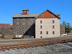
Eventually, blast furnaces for production of iron and later steel opened in the area. Iron and steel production attracted the Potts family, iron masters by trade. They established a forge and built a large home just west of the Manatawny Creek. John Potts founded a town in 1761 on part of the 995 acres (4.03 km2) that he owned. It is the home of the nation's oldest mill, Pottstown Roller Mill.[citation needed]
Over time, Pottsgrove grew, and in 1815 it was incorporated under the name Pottstown, becoming the second borough in Pennsylvania, after Norristown.
The Philadelphia & Reading Railroad mainline reached Pottstown in 1838. The extension of the railroad to Mount Carbon in 1842 facilitated the movement of raw materials and finished goods that helped Pottstown's economy grow. In a few years after the extension of the railroad, the population grew from 600 to 1,850. Pottstown's metal production grew; steel from the borough was used in the Panama Canal and Golden Gate Bridge.[4]
In 1944, the borough adopted a city manager form of government. By 1964, the borough saw the need to reorganize the municipal government. At the time, it had one of the largest borough councils in the state, with 20 members. This was reduced to seven members in redrawn wards.

The High Street Historic District, Old Pottstown Historic District, Pottsgrove Mansion, Grubb Mansion, Jefferson Elementary School, Pottstown Roller Mill, Reading Railroad Pottstown Station, and Henry Antes House are on the National Register of Historic Places.[5]
Politics and government[]
Pottstown has a city manager form of government with a mayor and a seven-member borough council. The mayor is Stephanie A. Henrick and the manager is Justin Keller.
The borough is part of the Fourth Congressional District (represented by Rep. Madeleine Dean), the 26th and 146th State House District (represented by state Rep. Tim Hennessey state Rep. Joe Ciresi respectively) and the 24th State Senate District (represented by Sen. Bob Mensch).
Geography[]
Pottstown is located at 40°14′59″N 75°38′25″W / 40.24972°N 75.64028°W (40.249690, -75.640262).[6]
According to the United States Census Bureau, the borough has a total area of 4.9 square miles (13 km2), of which 4.8 square miles (12 km2) is land and 0.1 square miles (0.2 km2 or 1.83%) is water.
Climate[]

The climate in this area is characterized by hot, humid summers and generally mild to cool winters. According to the Köppen Climate Classification system, Pottstown, Pennsylvania has a humid subtropical climate, abbreviated "Cfa" on climate maps.[7] Using the freezing mark as a boundary (as is more common in the US), the climate is hot-summer humid continental (Dfa). The hardiness zone is 7a bordering on 6b.
| hideClimate data for Pottstown, Pennsylvania | |||||||||||||
|---|---|---|---|---|---|---|---|---|---|---|---|---|---|
| Month | Jan | Feb | Mar | Apr | May | Jun | Jul | Aug | Sep | Oct | Nov | Dec | Year |
| Average high °F (°C) | 38 (3) |
39 (4) |
50 (10) |
61 (16) |
73 (23) |
81 (27) |
86 (30) |
83 (28) |
77 (25) |
66 (19) |
52 (11) |
41 (5) |
62 (17) |
| Daily mean °F (°C) | 31 (−1) |
31 (−1) |
41 (5) |
51 (11) |
62 (17) |
71 (22) |
76 (24) |
73 (23) |
67 (19) |
56 (13) |
44 (7) |
34 (1) |
53 (12) |
| Average low °F (°C) | 25 (−4) |
24 (−4) |
32 (0) |
42 (6) |
52 (11) |
61 (16) |
66 (19) |
64 (18) |
57 (14) |
46 (8) |
37 (3) |
27 (−3) |
44 (7) |
| Average precipitation inches (mm) | 3.3 (84) |
3.2 (81) |
3.8 (97) |
3.3 (84) |
4.2 (110) |
3.8 (97) |
4.8 (120) |
4 (100) |
3.2 (81) |
3 (76) |
3.2 (81) |
3.3 (84) |
43 (1,100) |
| Source: Weatherbase[8] | |||||||||||||
Demographics[]
| Historical population | |||
|---|---|---|---|
| Census | Pop. | %± | |
| 1830 | 676 | — | |
| 1840 | 721 | 6.7% | |
| 1850 | 1,664 | 130.8% | |
| 1860 | 2,380 | 43.0% | |
| 1870 | 4,125 | 73.3% | |
| 1880 | 5,305 | 28.6% | |
| 1890 | 13,285 | 150.4% | |
| 1900 | 13,696 | 3.1% | |
| 1910 | 15,599 | 13.9% | |
| 1920 | 17,431 | 11.7% | |
| 1930 | 19,430 | 11.5% | |
| 1940 | 20,194 | 3.9% | |
| 1950 | 22,589 | 11.9% | |
| 1960 | 26,144 | 15.7% | |
| 1970 | 25,355 | −3.0% | |
| 1980 | 22,729 | −10.4% | |
| 1990 | 21,831 | −4.0% | |
| 2000 | 21,859 | 0.1% | |
| 2010 | 22,377 | 2.4% | |
| 2019 (est.) | 22,600 | [2] | 1.0% |
| Sources:[9][10][11] | |||
| Year | Republican | Democratic |
|---|---|---|
| 2020 | 35.1% 3,573 | 63.2% 6,429 |
| 2016 | 36.6% 3,245 | 58.3% 5,160 |
| 2012 | 33.3% 2,825 | 65.1% 5,527 |
| 2008 | 29.2% 2,737 | 69.5% 6,506 |
| 2004 | 38.0% 3,069 | 61.3% 4,950 |
| 2000 | 40.0% 2,459 | 56.1% 3,448 |
As of the 2010 census, the borough was 72.1% White, 19.5% Black or African American, 0.3% Native American, 0.9% Asian, 0.1% Native Hawaiian, and 4.4% were two or more races. 8.0% of the population were of Hispanic or Latino ancestry [1].
As of 2006-2008 Census Bureau Estimates,[13] there were 22,018 people living in Pottstown. The racial makeup of the borough was 72.1% White, 19.4% African American, 0.2% Native American, 0.9% Asian, 0.0% Pacific Islander, 2.2% from other races, and 5.1% from two or more races. Hispanic or Latino of any race were 5.6% of the population.
As of the census[10] of 2000, there were 21,859 people, 9,146 households, and 5,533 families residing in the borough. The population density was 4,526.3 people per square mile (1,747.4/km2). There were 9,973 housing units at an average density of 2,065.1 per square mile (797.2/km2). The racial makeup of the borough was 79.34% White, 15.06% African American, 0.23% Native American, 0.65% Asian, 0.09% Pacific Islander, 1.89% from other races, and 2.75% from two or more races. Hispanic or Latino of any race were 4.53% of the population.
There were 9,146 households, out of which 29.1% had children under the age of 18 living with them, 41.3% were married couples living together, 14.7% had a female householder with no husband present, and 39.5% were non-families. 33.5% of all households were made up of individuals, and 13.4% had someone living alone who was 65 years of age or older. The average household size was 2.36 and the average family size was 3.02.
In the borough the population was spread out, with 25.6% under the age of 18, 7.5% from 18 to 24, 30.9% from 25 to 44, 19.8% from 45 to 64, and 16.2% who were 65 years of age or older. The median age was 36 years. For every 100 females, there were 90.5 males. For every 100 females age 18 and over, there were 85.6 males.
The median income for a household in the borough was $35,785, and the median income for a family was $45,734. Males had a median income of $34,923 versus $26,229 for females. The per capita income for the borough was $19,078. About 8.7% of families and 11.3% of the population were below the poverty line, including 15.2% of those under age 18 and 8.8% of those age 65 or over.
Transportation[]

The main east-west street in Pottstown is High Street, which continues east of the borough as Ridge Pike. The main north-south street in the borough is Hanover Street. The U.S. Route 422 freeway passes to the south of Pottstown and heads east to King of Prussia and Philadelphia and west to Reading. Pennsylvania Route 100 runs north-south through the Pottstown area, heading south to West Chester and north to Allentown. Pennsylvania Route 663 begins at PA 100 in Pottstown and follows King Street east and Charlotte Street northeast before leaving the borough and continuing to Pennsburg and Quakertown. Pennsylvania Route 724 runs along the south bank of the Schuylkill River in Chester County.[14]
Local bus service in the Pottstown area is owned, funded, and administered by the Borough of Pottstown and operated by Pottstown Area Rapid Transit (PART). PART operates five routes Monday through Saturday out of the Charles W. Dickinson Transportation Center in downtown Pottstown along with a paratransit service for disabled people.[15] SEPTA's Route 93 bus connects Pottstown with the Norristown Transportation Center in Norristown.[16]
Pottstown is serviced by Pottstown Municipal Airport, a general aviation airport, and a short distance from Pottstown is Heritage Field Airport located in Limerick.
Passenger train service between Reading/Pottstown and Philadelphia was operated by Conrail under the auspices of SEPTA until July 29, 1981, when all non-electrified routes were terminated. Efforts to reinstitute commuter trains, such as the Schuylkill Valley Metro, have been unsuccessful. The station still exists and is currently home to a district justice office. Norfolk Southern Railway provides freight rail service to Pottstown along the Harrisburg Line. The Colebrookdale Railroad is a heritage railway running from Pottstown to Boyertown.
Education[]

Public library[]
- Pottstown Regional Public Library
Colleges[]
- Montgomery County Community College – West Campus
Public School Districts[]
- The Pottstown School District serves the borough.
- The Pottsgrove School District serves the surrounding townships in Montgomery County.
- The Owen J. Roberts School District serves the suburban/rural area to the south of the borough in Chester County, such as Warwick Township, East Nantmeal Township, South Coventry Township, North Coventry Township, East Vincent Township, East Coventry Township and West Vincent Township. It consists of five elementary schools, a middle school, and the Owen J. Roberts High School.
Private Schools[]
- The Hill School
- Wyndcroft School
- Saint Aloysius School
- Stowe Lighthouse Christian Academy
- West-Mont Christian Academy
Media[]
Newspapers[]
Pottstown Mercury[]
The Mercury is the smallest-circulation newspaper in the U.S. to have won two Pulitzer Prizes. The first came in 1979 in the Spot News Photography category by staff photographer Tom Kelly. The second came in 1990 for Editorial Writing by Tom Hylton.
Television[]
PCTV[]
PCTV (Pottstown Community TV) is owned and operated by the Borough of Pottstown and provides local Government-access television (GATV) programming over Comcast Cable TV in over 77,000 homes in western Montgomery County, northern Chester County and eastern Berks County. In existence since 1983, PCTV produces programming on three local Cable Channels: 22, 27 and 98.[17]
PCTV also covers local high school sports such as football, basketball, swimming or baseball.
Radio[]
WPAZ operates at 1370AM and serves the Greater Philadelphia Area. Originally WPAZ, the station changed its call letters to WBZH on October 28, 2011, and back to WPAZ on January 25, 2013. On November 1, 2013, the station began a traditional Christian music format of religious hymns and songs.
Notable people[]
- Jacob Albright, a founder of United Methodist Church
- Aaron Beasley, NFL cornerback for Jacksonville Jaguars, New York Jets, and Atlanta Falcons
- Howie Bedell, MLB outfielder for the Milwaukee Braves and the Philadelphia Phillies , coach and front-office executive for various organizations
- John R. Brooke, Union general of American Civil War and Spanish–American War
- Dante Calabria, former professional Italian basketball player
- Naomi Childers, silent-film actress
- Jack Deloplaine, former NFL running back
- Brett Eppehimer, professional basketball player
- Nick Eppehimer, professional basketball player
- Danny García, professional boxer; former WBC welterweight champion and unified WBA (Super), WBC, Ring magazine, and lineal light welterweight champion
- Loren Gray, singer-songwriter and social media personality
- Al Grey, jazz trombonist, known for plunger technique, featured with Count Basie as soloist
- Calvin Grove, professional boxer; former IBF featherweight champion
- Daryl Hall, member of Grammy Award-winning rock group Hall & Oates, inducted in Rock and Roll Hall of Fame
- Dick Harter, college and NBA basketball coach
- Geof Manthorne, cake artist, co-star of Food Network's reality TV series Ace Of Cakes
- Keith "Bang Bang" McCurdy, celebrity tattoo artist
- Jim Mickle, film director
- Hildegard Peplau, nursing theorist; created middle-range nursing theory of interpersonal relations
- John Potts, Ironmaster, founder of Pottstown.
- Dave Ricketts, MLB catcher and coach with St. Louis Cardinals and Pittsburgh Pirates
- Dick Ricketts, NBA power forward and MLB pitcher; selected by St. Louis Hawks with first pick of 1955 NBA draft
- George Seasholtz, former NFL fullback for Milwaukee Badgers
- Amanda Smith, founder of Mrs. Smith's Pies
- Bobby Shantz, former MLB pitcher; 8x Gold Glove Award winner, 1952 AL MVP
- Don Strock, former NFL quarterback for Miami Dolphins, former head coach of Florida International University
- Earl Strom, former NBA referee, member of Naismith Memorial Basketball Hall of Fame
- Frank D. Wagner, Vice admiral in the U.S. Navy
- Irving Price Wanger, Republican member of the U.S. House of Representatives from Pennsylvania
- Rian Wallace, former NFL linebacker for Pittsburgh Steelers and The Washington Football Team
- Buck Weaver, former MLB shortstop for Chicago White Sox, banned after 1919 Black Sox Scandal
- Harry Joe Yorgey, professional boxer
References[]
- ^ "2019 U.S. Gazetteer Files". United States Census Bureau. Retrieved July 28, 2020.
- ^ Jump up to: a b "Population and Housing Unit Estimates". United States Census Bureau. May 24, 2020. Retrieved May 27, 2020.
- ^ "Pottsgrove Manor History". MontcoPA.org. Retrieved 22 Nov 2014.
- ^ Pottstown History from Official City Website Archived 2008-08-08 at the Wayback Machine
- ^ "National Register Information System". National Register of Historic Places. National Park Service. July 9, 2010.
- ^ "US Gazetteer files: 2010, 2000, and 1990". United States Census Bureau. 2011-02-12. Retrieved 2011-04-23.
- ^ Climate Summary for Pottstown, Pennsylvania
- ^ "Weatherbase.com". Weatherbase. 2013. Retrieved on October 24, 2013.
- ^ "Census of Population and Housing". U.S. Census Bureau. Retrieved 11 December 2013.
- ^ Jump up to: a b "U.S. Census website". United States Census Bureau. Retrieved 2008-01-31.
- ^ "Incorporated Places and Minor Civil Divisions Datasets: Subcounty Resident Population Estimates: April 1, 2010 to July 1, 2012". Population Estimates. U.S. Census Bureau. Archived from the original on 11 June 2013. Retrieved 11 December 2013.
- ^ "Montgomery County Election Results". Montgomery County, Pennsylvania. Retrieved January 16, 2017.
- ^ "2006-2008 American Community Survey 3-Year Estimates". Archived from the original on 2020-02-16. Retrieved 2010-08-06.
- ^ Google (November 21, 2013). "overview of Pottstown, Pennsylvania" (Map). Google Maps. Google. Retrieved November 21, 2013.
- ^ "Ride Guide" (PDF). Pottstown Area Rapid Transit. Retrieved April 4, 2018.
- ^ SEPTA Official Transit & Street Map Suburban (PDF) (Map). SEPTA. Retrieved May 2, 2016.
- ^ http://www.pottscommtv.com/pctv1.htm
External links[]
| Wikivoyage has a travel guide for Pottstown. |
| Wikisource has the text of the 1911 Encyclopædia Britannica article Pottstown. |
- Borough of Pottstown
- Chamber of Commerce
- . . 1914.
| show Places adjacent to Pottstown, Pennsylvania |
|---|
| show Articles relating to Pottstown, Pennsylvania |
|---|


| show Authority control |
|---|
- Populated places on the Schuylkill River
- Populated places established in 1752
- Boroughs in Montgomery County, Pennsylvania
- 1815 establishments in Pennsylvania