Kaffrine Department
This article needs additional citations for verification. (January 2017) |
Kaffrine | |
|---|---|
 | |
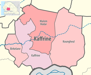 Location in the Kaffrine Region | |
| Country | |
| Region | Kaffrine Region |
| Capital | Kaffrine |
| Area | |
| • Total | 11,102 km2 (4,287 sq mi) |
| Population (2013 census) | |
| • Total | 207,676 |
| • Density | 19/km2 (48/sq mi) |
| Time zone | UTC+0 (GMT) |
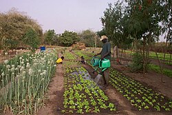
Kaffrine Department is one of the 45 departments of Senegal, and is located in the Kaffrine Region, formerly part of the Kaolack Region.
The main settlements are the communes of Kaffrine and Nganda. In addition there are the rural communities (Communautés rurales) of , , , , , and .[1]
Historic sites in Kaffrine department[2][]
- Megalithic site of Keur Ali Ngane
- Megalithic site of Sorokogne
- Megalithic site of Keur Modi Toy
- Megalithic site of Pathé Tiangaye
- Megalithic site of Keur Ali Lobé
- Megalithic site of Kounou Mbayèn
References[]
- ^ "Découpage administratif de la région de Kaffrine". au Senegal.com. Retrieved 12 November 2016.
- ^ List of historic sites Archived 2007-11-17 at the Wayback Machine
Coordinates: 14°07′00″N 15°42′00″W / 14.11667°N 15.70000°W

This Senegal location article is a stub. You can help Wikipedia by . |
Categories:
- Departments of Senegal
- Kaffrine Region
- Senegal geography stubs