Kaikohe
Kaikohe | |
|---|---|
 Kaikohe | |
| Coordinates: 35°24′27″S 173°47′59″E / 35.40750°S 173.79972°ECoordinates: 35°24′27″S 173°47′59″E / 35.40750°S 173.79972°E | |
| Country | New Zealand |
| Region | Northland Region |
| District | Far North District |
| Population (June 2020)[1] | |
| • Total | 4,820 |
| Postcode(s) | 0405 |

Kaikohe is a town in the Far North District of New Zealand, situated on State Highway 12 about 260 km from Auckland. It is the largest inland town and highest community above sea level in the Northland Region. With a population of over 4000 people[1] it is a shopping and service centre for an extensive farming district and is sometimes referred to as "the hub of the north".[2]
Geography[]
The town is situated on a relatively level site surrounded mainly by undulating plains[3] and is nearby many former pā sites including Nga Huha, Pouerua, Te Rua-hoanga, Ngaungau, Kaiaia, Te Tou o Roro, Taka-poruruku, Tapa-huarau, Nga Puke-pango, Maunga-turoto, and Maunga-kawakawa.[4] On the western edge of town, Kaikohe Hill rises 300 m above sea level, allowing views of the imposing sand dunes on the Hokianga Harbour to the west, farmlands to the east and south toward Mount Hikurangi (625 m).
To the north of the Putahi volcanic ridge is Lake Omapere, five km in length, but only two to three metres deep. Around five km to the east is the small village of Ngawha Springs, where hot water springs rise to the surface from the Ngawha geothermal field, and where the Northland Region Corrections Facility is situated.
There are several volcanic scoria cones in the area, which are part of the Kaikohe-Bay of Islands volcanic field.
Demographics[]
| Year | Pop. | ±% p.a. |
|---|---|---|
| 2006 | 4,041 | — |
| 2013 | 3,855 | −0.67% |
| 2018 | 4,437 | +2.85% |
| Source: [5] | ||
Kaikohe had a population of 4,437 at the 2018 New Zealand census, an increase of 582 people (15.1%) since the 2013 census, and an increase of 396 people (9.8%) since the 2006 census. There were 1,287 households. There were 2,187 males and 2,247 females, giving a sex ratio of 0.97 males per female. Of the total population, 1,353 people (30.5%) were aged up to 15 years, 927 (20.9%) were 15 to 29, 1,623 (36.6%) were 30 to 64, and 531 (12.0%) were 65 or older. Figures may not add up to the total due to rounding.
Ethnicities were 33.9% European/Pākehā, 78.4% Māori, 8.4% Pacific peoples, 4.0% Asian, and 0.9% other ethnicities. People may identify with more than one ethnicity.
The percentage of people born overseas was 6.5, compared with 27.1% nationally.
Although some people objected to giving their religion, 37.8% had no religion, 42.0% were Christian, and 14.3% had other religions.
Of those at least 15 years old, 246 (8.0%) people had a bachelor or higher degree, and 825 (26.8%) people had no formal qualifications. The median income was $19,000. The employment status of those at least 15 was that 1,020 (33.1%) people were employed full-time, 411 (13.3%) were part-time, and 342 (11.1%) were unemployed.[5]
Ngapuhi statistical area[]
The area around Kaikohe, from the southern side of Lake Omapere to and including Ngawha Springs, is the statistical area of Ngapuhi, covering 175 square kilometres.
| Year | Pop. | ±% p.a. |
|---|---|---|
| 2006 | 1,506 | — |
| 2013 | 1,371 | −1.33% |
| 2018 | 1,797 | +5.56% |
| Source: [6] | ||
Ngapuhi had a population of 1,797 at the 2018 New Zealand census, an increase of 426 people (31.1%) since the 2013 census, and an increase of 291 people (19.3%) since the 2006 census. There were 462 households. There were 1,065 males and 729 females, giving a sex ratio of 1.46 males per female. Of the total population, 369 people (20.5%) were aged up to 15 years, 375 (20.9%) were 15 to 29, 852 (47.4%) were 30 to 64, and 201 (11.2%) were 65 or older. Figures may not add up to the total due to rounding.
Ethnicities were 42.9% European/Pākehā, 71.0% Māori, 7.2% Pacific peoples, 2.7% Asian, and 1.7% other ethnicities. People may identify with more than one ethnicity.
The percentage of people born overseas was 7.7, compared with 27.1% nationally.
Although some people objected to giving their religion, 39.1% had no religion, 40.4% were Christian, and 13.9% had other religions.
Of those at least 15 years old, 114 (8.0%) people had a bachelor or higher degree, and 285 (20.0%) people had no formal qualifications. The median income was $16,100. The employment status of those at least 15 was that 489 (34.2%) people were employed full-time, 144 (10.1%) were part-time, and 165 (11.6%) were unemployed.[6]
History and culture[]
Early history[]
Originally a Māori village called Opango, Kaikohe is recognised as being the very heart of the culture of the great Ngāpuhi iwi. In the early 19th century a rival Māori tribe raided the village and fugitives subsisted among the Kohekohe (a native tree) groves on Tokareireia (Kaikohe Hill). After the incident, the village became known as Kaikohekohe (kai meaning food) but was later shortened to Kaikohe.
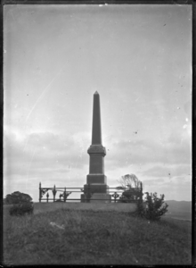
Battles during the Flagstaff War (also known as 'Hōne Heke's Rebellion') were fought around Kaikohe: at Hōne Heke's Pā at Puketutu on the shores of Lake Omapere; followed by a battle at Te Ahuahu; with the warriors of Te Ruki Kawiti fighting the Battle of Ohaeawai. St. Michael's Anglican Church in nearby Ngawha Springs was built on the site of the pā at which the battle took place. The warrior chief Hōne Heke settled in Kaikohe after fighting ceased, and died there in 1850.[7] His grand-nephew Hone Heke Ngapua, MP for Northern Maori, also lived in Kaikohe. In April 1911, a monument to him was unveiled on Kaikohe Hill by Sir James Carroll, acting Prime Minister. A park in the town is dedicated to Rawiri Taiwhanga who has a very strong claim to being New Zealand's first commercial dairy farmer. He milked a herd of cows and sold butter in 1834.

To the west of the town is the Aperahama Anglican Church, named after Aperahama Te Awa. It was opened in 1885, a year after his death, and he is buried in the churchyard. It is on the site of an earlier church, built in 1837, and the existing memorial gates were erected and dedicated for that earlier church.[8][9] The building is registered as a place ".... of special or outstanding historical or cultural heritage significance or value...." by Heritage New Zealand.
Also in the town is a Pioneer Village, a 19th-century Northland community recreated with all its colourful atmosphere, history and detail.
Railway links[]
Kaikohe was linked to the national rail network with the arrival of a branch line railway being built from Otiria on the North Auckland Line to Kaitaia, which opened to Kaikohe on 1 May 1914. The line continued north to Ōkaihau, opening on 29 October 1923 and eventually reached Rangiahua, although the section between Okaihau and Rangiahua was never handed over to the New Zealand Railways Department for operation and the line never reached Kaitaia. The line between Okaihau and Rangiahua was operated for a short time by the Public Works Department before being closed and dismantled during World War II. The railway through Kaikohe thus became known as the Okaihau Branch.
Although Kaikohe became the service centre of the Far North, it failed to generate much rail traffic in the early years of the line. During the first ten months of existence, just 1,500 tons of inbound freight was carried, with roughly half that carried outbound, and the decline continued to the point where in 1918 Kaikohe lost its stationmaster. Minimal services were offered, and although losses increased up to 1930, fortunes had somewhat improved by 1940, and by 1950 there was sufficient traffic to justify six trains each way a week. Two carried only freight, while four were mixed goods/passenger trains. At that time, a full complement of staff was again employed at Kaikohe.
When railcars were introduced on services north of Auckland in November 1956, they ran through Kaikohe all the way to Okaihau. Previously, a carriage train known as the Northland Express had run from Auckland to Opua with connections to Kaikohe and Okaihau via the mixed trains, but with the change of the northern terminus to Okaihau, the branch increased in importance. This proved to be short-lived; in July 1967 the very popular railcar service was withdrawn due to mechanical problems plaguing the railcars. Passengers had to use the mixed trains, with significantly older rolling stock on a slower schedule. Demand decreased and the branch closed to passengers on 21 June 1976.
In 1977, a relaxation of road transport laws led to a decline in freight traffic on the line and forestry proposals that would have required a railway service failed to eventuate. Scheduled trains were cancelled beyond Kaikohe on 12 August 1983, and for a little over four years the line was shunted when required. The branch closed on 1 November 1987 and the track has been lifted. The rail corridor through Kaikohe is still owned by the New Zealand Railways Corporation, being retained in case any forestry proposals come to fruition and the railway is again required, although it now forms part of the Twin Coast Cycle Trail.
Marae[]
The Kaikohe area has three Ngāpuhi marae:
- Te Kiore Marae and Te Kiore meeting house are affiliated with Ngāti Whakaminenga.
- Te Iringa or Parihaka Marae and its Parihaka meeting house are affiliated with Ngāti Hinemutu and Ngāti Tautahi.
- Ōkorihi Marae is affiliated with Ngāti Hinemutu, Ngāti Tautahi and Ngāti Ueoneone; its meeting house burned down in 2003.[10][11]
Attractions[]
Kaikohe is the geographical centre of the Far North. Within a 50 km radius are the famous Bay of Islands and the Waipoua, and Omahuta kauri forests. Also not far away are the Whangaroa and Hokianga harbours, the limestone caves, many beautiful beaches and secluded bays, and historic Kerikeri which is Northland's largest town. It is also the home of the Kaikohe Demolition Derby which featured in the "Kaikohe Demolition" movie[12] filmed by Florian Habicht.
The Twin Coast Cycle Trail, part of the New Zealand Cycle Trail project, runs through the town.
Notable residents[]
Former New Zealand Prime Minister David Lange lived in Kaikohe for a time. Former New Zealand First Member of Parliament and brother of Winston Peters, Jim Peters, is a current resident. Christian Huriwai, winner of the street unicycling competition at the 2010 World Championships in Wellington, is a current resident. The New Zealand Kiwis rugby league player Olsen Filipaina was born in the town.[13]
Education[]
Northland College is a secondary (years 9-15) school with a roll of 330.[14] It was founded in 1947 on the site of a former United States Army camp.[15] The school incorporates a working farm and forestry block.[16] A $14 million reconstruction of the school was completed in 2016-17.[17]
Kaikohe Intermediate School (years 7-8) has a roll of 132.[18] It was established in 1969, taking over the grounds of the former Kaikohe Primary School.[15]
Kaikohe East School and Kaikohe West School are contributing primary (years 1-6) schools with rolls of 254[19] and 195[20] respectively. Kaikohe West School opened in 1882 as Kaikohe Native School. The name changed to Kaikohe Maori School in the mid-1950s, and to the current name in 1969.[21] Kaikohe East School has a Māori unit offering bilingual and total immersion classes.[15]
Te Kura Kaupapa Māori o Kaikohe is a composite (years 1-15) school with a roll of 245.[22] It is a Kura Kaupapa Māori school which teaches fully in the Māori language through to Year 13. The school originated in the early 1990s and opened on its present site about 2003.[15]
Kaikohe Christian School is a state-integrated composite school (years 1-13) with a roll of 183[23] The school has a Kaikohe campus and a smaller Kerikeri campus which opened in 1985[15] and 2004,[24] respectively.
All these schools are coeducational. School rolls are as of March 2021[25].
NorthTec polytechnic also has a campus in Kaikohe.[26]
Notes[]
- ^ Jump up to: a b "Population estimate tables - NZ.Stat". Statistics New Zealand. Retrieved 22 October 2020.
- ^ "EDITORIAL - Hard-hit Kaikohe needs to reinvent itself". The Northern Advocate. 11 November 2007.
- ^ "KAIKOHE". Te Ara: The Encyclopedia of New Zealand. Retrieved 11 December 2012.
- ^ Best, Elsdon (1927). "Old Forts of the Taiamai District, Bay of Islands". The Pa Maori. Whitcombe and Tombs Limited.
- ^ Jump up to: a b "Statistical area 1 dataset for 2018 Census". Statistics New Zealand. March 2020. Kaikohe (103500). 2018 Census place summary: Kaikohe
- ^ Jump up to: a b "Statistical area 1 dataset for 2018 Census". Statistics New Zealand. March 2020. Ngapuhi (103400). 2018 Census place summary: Ngapuhi
- ^ "The Church Missionary Gleaner, June 1851". Heke. Adam Matthew Digital. Retrieved 18 October 2015.
- ^ "Early Church History in Kaikohe".
- ^ "Aperahama, Kaikohe, Northland". Don Donovan.
- ^ "Te Kāhui Māngai directory". tkm.govt.nz. Te Puni Kōkiri.
- ^ "Māori Maps". maorimaps.com. Te Potiki National Trust.
- ^ "Kaikohe Demolition". The New Zealand Film Archive. Archived from the original on 2008-07-08. Retrieved 2008-08-23.
- ^ Skene, Patrick (2020). The big O. Auckland: Mower. p. 30. ISBN 978-1-988516-84-4.
- ^ Education Counts: Northland College
- ^ Jump up to: a b c d e "Education". Archived from the original on October 14, 2008.
- ^ "Northland College - The School". Archived from the original on 2007-10-08. Retrieved 2008-01-17.
- ^ "College rebuild a boon".
- ^ Education Counts: Kaikohe Intermediate
- ^ Education Counts: Kaikohe East School
- ^ Education Counts: Kaikohe West School
- ^ "Kaikohe West School - Information". Archived from the original on 2007-09-08. Retrieved 2008-01-17.
- ^ Education Counts: Te Kura Kaupapa Māori o Kaikohe
- ^ Education Counts: Kaikohe Christian School
- ^ "Kaikohe Christian School - About".
- ^ "New Zealand Schools Directory". New Zealand Ministry of Education. Retrieved 27 April 2021.
- ^ "Kaikohe". NorthTec. Retrieved 4 March 2010.
External links[]
| Authority control |
|
|---|
- Far North District
- Populated places in the Northland Region