Kaikohe-Bay of Islands volcanic field
| Kaikohe-Bay of Islands volcanic field | |
|---|---|
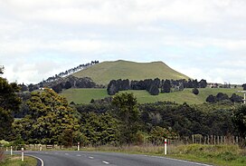 Te Ahuahu, looking from Waimate North | |
| Highest point | |
| Coordinates | 35°20′54″S 173°50′55″E / 35.348316°S 173.848686°E |
| Geography | |
 Kaikohe-Bay of Islands volcanic field | |
| Geology | |
| Last eruption | 1300 to 1800 years ago |

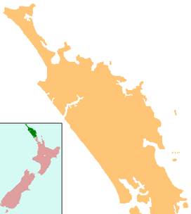
The Kaikohe-Bay of Islands volcanic field is in the Northland Region of New Zealand. Eruptions have occurred over the last 10 million years. All the cones older than 2 million years have eroded away, leaving plateaus from Okaihau to Kerikeri and north to Whangaroa. In the southern part of the field, around 12 small basaltic scoria cones, and a rhyolite dome erupted in the last 500,000 years around Kaikohe. The field is considered dormant, rather than extinct.[1]
List of volcanoes[]
The volcanoes in the southern part of the field include:[1]
- Kaikohe Hill
- Maungaturoto
- Pouerua
- Putahi
- Tarahi
- Tauanui
- Te Ahuahu
- Te Puke – last erupted 1300 to 1800 years ago[2]
References[]
- ^ a b Hayward, Bruce; Smith, Ian (2002). "Field Trip 7: A Taste of Northland Geology" (PDF). In Smith, Vicki; Grenfell, Hugh (eds.). Field Trip Guides, GSNZ Annual Conference "Northland 2002". Geological Society of NZ Miscellaneous Publication 112B. Retrieved 28 March 2012.
- ^ "Kaikohe-Bay of Islands". Global Volcanism Program. Smithsonian Institution. Retrieved 28 March 2021.
This Northland Region-related geography article is a stub. You can help Wikipedia by . |
Categories:
- Volcanism of New Zealand
- Far North District
- Landforms of the Northland Region
- Bay of Islands
- Northland Region geography stubs