Kanggye
This article needs additional citations for verification. (December 2015) |
Kanggye
강계시 | |
|---|---|
| Korean transcription(s) | |
| • Chosŏn'gŭl | 강계시 |
| • Hancha | 江界市 |
| • McCune-Reischauer | Kanggye-si |
| • Revised Romanization | Ganggye-si |
 Factory in Kanggye | |
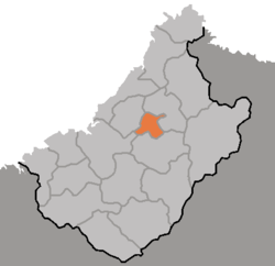 Map of Chagang showing the location of Kanggye | |
 | |
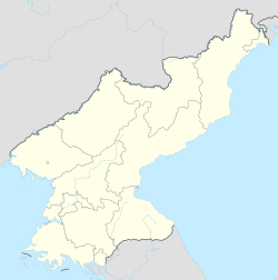 Kanggye Location within North Korea | |
| Coordinates: 40°58′N 126°36′E / 40.967°N 126.600°E | |
| Country | |
| Province | Chagang Province |
| Administrative divisions | 34 tong, 2 ri |
| Area | |
| • Total | 263.667 km2 (101.802 sq mi) |
| Population (2008) | |
| • Total | 251,971 |
| • Dialect | P'yŏngan |
| Time zone | UTC+9 (Pyongyang Time) |

Kanggye (Korean pronunciation: [kɐŋ.ɡje]) is the provincial capital of Chagang, North Korea and has a population of 251,971. Because of its strategic importance, derived from its topography, it has been of military interest from the time of the Joseon Dynasty (1392-1910).
History[]
During the Korean War, after being driven from Pyongyang, Kim Il Sung and his government temporarily moved the capital to Kanggye after first moving temporarily to Sinuiju.[1][2]
Geography[]
Kanggye is located at the merging point of four rivers, including the Changja River.
Climate[]
Kanggye has a humid continental climate (Köppen climate classification: Dwa).
| hideClimate data for Kanggye (1981–2010) | |||||||||||||
|---|---|---|---|---|---|---|---|---|---|---|---|---|---|
| Month | Jan | Feb | Mar | Apr | May | Jun | Jul | Aug | Sep | Oct | Nov | Dec | Year |
| Average high °C (°F) | −5.1 (22.8) |
−0.1 (31.8) |
7.1 (44.8) |
16.4 (61.5) |
22.7 (72.9) |
27.2 (81.0) |
28.8 (83.8) |
28.7 (83.7) |
23.6 (74.5) |
16.2 (61.2) |
5.5 (41.9) |
−2.6 (27.3) |
14.0 (57.2) |
| Daily mean °C (°F) | −12.7 (9.1) |
−7.3 (18.9) |
−0.5 (31.1) |
9.2 (48.6) |
15.6 (60.1) |
20.3 (68.5) |
23.2 (73.8) |
22.7 (72.9) |
16.4 (61.5) |
8.6 (47.5) |
−0.5 (31.1) |
−9.1 (15.6) |
7.2 (45.0) |
| Average low °C (°F) | −18.7 (−1.7) |
−13.6 (7.5) |
−5.1 (22.8) |
2.7 (36.9) |
9.2 (48.6) |
14.8 (58.6) |
19.1 (66.4) |
18.3 (64.9) |
11.1 (52.0) |
2.7 (36.9) |
−5.2 (22.6) |
−14.2 (6.4) |
1.8 (35.2) |
| Average precipitation mm (inches) | 9.6 (0.38) |
12.1 (0.48) |
21.1 (0.83) |
44.4 (1.75) |
83.7 (3.30) |
129.7 (5.11) |
206.7 (8.14) |
153.6 (6.05) |
72.4 (2.85) |
44.8 (1.76) |
29.4 (1.16) |
16.1 (0.63) |
823.6 (32.43) |
| Average precipitation days (≥ 0.1 mm) | 5.3 | 4.5 | 6.0 | 8.0 | 10.8 | 12.5 | 16.1 | 12.5 | 7.7 | 7.4 | 7.2 | 6.7 | 104.7 |
| Average snowy days | 8.8 | 7.5 | 7.5 | 1.8 | 0.0 | 0.0 | 0.0 | 0.0 | 0.0 | 0.8 | 6.1 | 9.5 | 42.0 |
| Average relative humidity (%) | 77.9 | 72.6 | 67.9 | 65.0 | 68.1 | 73.6 | 79.8 | 80.3 | 78.2 | 74.0 | 77.4 | 79.3 | 74.5 |
| Source: Korea Meteorological Administration[3] | |||||||||||||
Administrative divisions[]
Kanggye is divided into 34 tong (neighbourhoods) and two ri (villages):
|
|
Transportation[]
Kanggye is a transportation hub, connected to other cities by road, rail and air. It lies at the junction of the Kanggye and Manp'o Lines. In addition, highways connect it to Pyongyang and other locations. The city is located near a military and civilian dual-purpose air station.
Kanggye has a trolleybus system, opened on April 17, 1992.[4] It is served by a fleet of at least 5 trolleybuses.
Broadcasting[]
Local radio station called "Kanggye Broadcasting(강계방송)"(originally founded in 1947 as a local broadcasting station for North Pyongan Province, became a local broadcasting station for Chagang Province in 1949),operated by the Chagang province broadcasting committee(자강도 방송위원회), is located, which airs programs that considers topics such as ideology education or local weather information.[5]
Culture[]
, , and the are located in the city.
Places of tourist interest include and .
Industry[]
From 1945, the manufacturing industry developed rapidly.
Kanggye has a mining industry producing copper, zinc ore, coal and graphite.
Kanggye hosts one of the main of Chagang province and North Korea.
Kanggye Timber Processing Factory[]

Kanggye Timber Processing Factory is a small state-run factory located in Kanggye City. At the start of operations, it produced only two kinds of furniture (dining tables and sterilized chopsticks) through manual labour. Over time it has developed into a comprehensive modernized furniture producer, producing woodwork with a hundred and dozens of modern facilities in production.
Amongst machinery in use are three- and four-faced automatic planes, all-purpose polishers, joining machines, and grooving saws.
Meanwhile, the factory has directed an effort into the programme of modernizing the drying job, which is an important part of the woodworking process. By making technical innovations (such as replacing a boiler-induced drying process drying ovens and using fuels other than coal) the factory increased production and lowered manpower.[citation needed]
- Kanggye Timber Processing Factory

Furniture produced in the factory

The external view of the factory


No.26 General Plant[]
The No.26 factory is the largest underground military facility in Korea. The plant manufactures ammunition which has been exported to Libya, Syria, Iran, Iraq and Egypt. It employs more than 20,000 workers and can produce 126,000 mortar rounds and 1.76 million rounds of rifle ammunition per year. On November 30, 1991, up to a thousand people were killed after a massive explosion at the plant.[6] Other sources put the number of fatalities at six times that amount or more based on the claims of survivors of the incident.[7]
See also[]
- Geography of North Korea
- List of cities in North Korea
- List of Korea-related topics
References[]
- ^ Mossman, Billy (June 29, 2005). United States Army in the Korean War: Ebb and Flow November 1950-July 1951. University Press of the Pacific. p. 51.
- ^ Sandler, Stanley (1999). The Korean War: No Victors, No Vanquished. The University Press of Kentucky. p. 108.
- ^ "30 years report of Meteorological Observations in North Korea" (in Korean). Korea Meteorological Administration. pp. 232–281. Archived from the original on 21 December 2020. Retrieved 21 December 2020.
- ^ "Kanggye". transphoto.org. Retrieved 2020-10-16.
- ^ "강계방송". Encyclopedia of Korean Culture. Retrieved 2021-02-02.
- ^ "The Kanggye explosion: a man-made disaster in North Korea - North Korea News". NK News. 12 January 2018.
- ^ "Remembering the Kanggye Tractor Factory incident of 1991". DailyNK.com / Unification Media Group. 13 February 2020.
Further reading[]
- Dormels, Rainer. North Korea's Cities: Industrial facilities, internal structures and typification. Jimoondang, 2014. ISBN 978-89-6297-167-5
External links[]
| Wikimedia Commons has media related to Kanggye. |

| Rank | Name | Administrative division | Pop. | Rank | Name | Administrative division | Pop. | ||
|---|---|---|---|---|---|---|---|---|---|
 Pyongyang 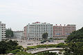 Hamhung |
1 | Pyongyang | Pyongyang Capital City | 3,255,288 | 11 | Sunchon | South Pyongan | 297,317 |  Chongjin  Nampo |
| 2 | Hamhung | South Hamgyong | 768,551 | 12 | Pyongsong | South Pyongan | 284,386 | ||
| 3 | Chongjin | North Hamgyong | 667,929 | 13 | Haeju | South Hwanghae | 273,300 | ||
| 4 | Nampo | South Pyongan Province | 366,815 | 14 | Kanggye | Chagang | 251,971 | ||
| 5 | Wonsan | Kangwon | 363,127 | 15 | Anju | South Pyongan | 240,117 | ||
| 6 | Sinuiju | North Pyongan | 359,341 | 16 | Tokchon | South Pyongan | 237,133 | ||
| 7 | Tanchon | South Hamgyong | 345,875 | 17 | Kimchaek | North Hamgyong | 207,299 | ||
| 8 | Kaechon | South Pyongan | 319,554 | 18 | Rason | Rason Special Economic Zone | 196,954 | ||
| 9 | Kaesong | North Hwanghae | 308,440 | 19 | Kusong | North Pyongan | 196,515 | ||
| 10 | Sariwon | North Hwanghae | 307,764 | 20 | Hyesan | Ryanggang | 192,680 | ||
| Authority control |
|
|---|
- Cities in Chagang