Hamhung
Hamhŭng
함흥시 | |
|---|---|
| Korean transcription(s) | |
| • Chosŏn'gŭl | 함흥시 |
| • Hancha | 咸興市 |
| • McCune-Reischauer | Hamhŭng-si |
| • Revised Romanization | Hamheung-si |
 A view of Hamhung | |
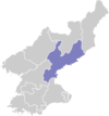
 Map of South Hamgyong showing the location of Hamhung | |
 | |
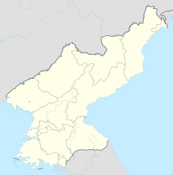 Hamhŭng Location within North Korea | |
| Coordinates: 39°55′N 127°32′E / 39.917°N 127.533°ECoordinates: 39°55′N 127°32′E / 39.917°N 127.533°E | |
| Country | |
| Region | Kwannam |
| Province | South Hamgyong |
| Administrative divisions | 7 kuyok |
| Area | |
| • Total | 330 km2 (130 sq mi) |
| Population (2008) | |
| • Total | 768,551 |
| • Dialect | Hamgyŏng |
| Time zone | UTC+9 (Pyongyang Time) |

Hamhŭng (Hamhŭng-si; Korean pronunciation: [ham.ɦɯŋ]) is North Korea's second largest city, and the capital of South Hamgyŏng Province. With an estimated population of 768,551, Hamhung is the second largest city by population in North Korea. Located in the southern part of the South Hamgyong province, Hamhung is the main and most popular metropolitan area in the province. Hamhung has a thriving local economy compared to other metropolitan areas in North Korea, and it is known by North Koreans as a great area of architectural construction that was centrally planned, and built by the government of North Korea.
Located on the Sea of Japan in the middle east of North Korea, Hamhung is the second biggest city in North Korea.
Administrative divisions[]
Hamhŭng is divided into 7 guyŏk (wards):[1]
|
Geography[]
Hamhŭng is on the left branch of the , on the eastern part of the Hamhŭng plain (함흥평야), in South Hamgyŏng Province, northeast North Korea. The Tonghŭngsan is 319 m (1,047 ft) high.
Climate[]
Hamhung has a humid continental climate (Köppen climate classification: Dwa), with warm, humid summers, and moderately cold, dry winters.
| hideClimate data for Hamhung (1981–2010) | |||||||||||||
|---|---|---|---|---|---|---|---|---|---|---|---|---|---|
| Month | Jan | Feb | Mar | Apr | May | Jun | Jul | Aug | Sep | Oct | Nov | Dec | Year |
| Average high °C (°F) | 1.9 (35.4) |
4.4 (39.9) |
9.3 (48.7) |
16.8 (62.2) |
21.8 (71.2) |
24.4 (75.9) |
26.7 (80.1) |
27.6 (81.7) |
24.2 (75.6) |
19.1 (66.4) |
10.9 (51.6) |
5.0 (41.0) |
16.0 (60.8) |
| Daily mean °C (°F) | −4.1 (24.6) |
−1.4 (29.5) |
3.5 (38.3) |
10.4 (50.7) |
15.6 (60.1) |
19.2 (66.6) |
22.5 (72.5) |
23.2 (73.8) |
18.5 (65.3) |
12.5 (54.5) |
5.0 (41.0) |
−1.0 (30.2) |
10.3 (50.5) |
| Average low °C (°F) | −9.6 (14.7) |
−6.9 (19.6) |
−1.7 (28.9) |
4.4 (39.9) |
10.1 (50.2) |
15.2 (59.4) |
19.2 (66.6) |
19.6 (67.3) |
14.0 (57.2) |
7.0 (44.6) |
−0.2 (31.6) |
−5.9 (21.4) |
5.4 (41.7) |
| Average precipitation mm (inches) | 12.5 (0.49) |
13.6 (0.54) |
24.3 (0.96) |
46.5 (1.83) |
70.2 (2.76) |
96.4 (3.80) |
199.9 (7.87) |
178.8 (7.04) |
102.9 (4.05) |
40.5 (1.59) |
46.5 (1.83) |
14.9 (0.59) |
847.0 (33.35) |
| Average precipitation days (≥ 0.1 mm) | 3.6 | 3.2 | 4.7 | 5.4 | 7.9 | 9.2 | 13.4 | 10.0 | 7.2 | 4.7 | 5.0 | 3.3 | 77.6 |
| Average snowy days | 5.0 | 4.2 | 3.9 | 0.3 | 0.0 | 0.0 | 0.0 | 0.0 | 0.0 | 0.0 | 1.1 | 3.4 | 17.9 |
| Average relative humidity (%) | 62.4 | 60.9 | 61.0 | 60.8 | 68.3 | 78.5 | 84.2 | 84.2 | 79.0 | 70.1 | 65.6 | 62.8 | 69.8 |
| Source: Korea Meteorological Administration[2] | |||||||||||||
History[]

Yi Seong-gye, founder of the Yi Dynasty, retired to the city after a successful palace coup by his son Yi Bang-won in 1400. Though his son sent envoys to reconcile, his father had them killed. A modern Korean expression, 'King's envoy to Hamhŭng' (Hamheungchasa), refers to a person who goes on a journey and is never heard from again.[3] It was known as Kankō during Japanese rule of Korea between 1910 and 1945. It was liberated by the Red Army on 22 August 1945.

The city was 80–90% destroyed by American air raids during the Korean War (1950-1953) and was occupied by ROK troops between 17 October 1950 and 17 December 1950. From 1955 to 1962, Hamhŭng was the object of a large-scale program of reconstruction and development by East Germany including the build-up of construction-related industries and intense training measures for Korean construction workers, engineers, city planners and architects. When the Bauhaus trained architect Konrad Püschel, the first Head of City Planning for the arrived in 1955, he was accompanied by about 175 members of the 'Deutsche Arbeitsgruppe (DAG)' as the project team was called.[4] The project ended two years earlier than scheduled and with a low profile because of the Sino-Soviet conflict and the opposing positions that North Korea and East Germany took on that issue.[5]
From 1960 to 1967, Hamhŭng was administered separately from South Hamgyŏng as a Directly Governed City (Chikhalsi). Before 1960 and since 1967, the city has been part of South Hamgyŏng Province.
In 1995, Hamhŭng witnessed, thus far, one of the only documented challenges to the North Korean government when famine-ravaged soldiers began a march toward Pyongyang. The revolt was quelled and the unit of soldiers was disbanded.[6]
The North Korean famine of the 1990s appears to have had a disproportionate effect on the people of Hamhung. Andrew Natsios, a former aid worker, USAID administrator, and author of The Great North Korean Famine, described Hamhung as "the city most devastated by [the] famine."[7] Contemporary published reports from The Washington Post[8] and Reuters[9] describe numerous fresh graves on the surrounding hillsides and report that many of Hamhung's children were stunted by malnutrition. One survivor claimed that more than 10% of the city's population died, with another 10% fleeing the city in search of food.[10] Despite previously being closed to foreigners, foreign nationals can now travel to Hamhung through the few approved North Korean tour operators.[11]
There is speculation that Hamhung, with its high proportion of chemists and the site of a chemical-industrial complex built by the Japanese during World War II, might be the center for North Korea's methamphetamine production.[12]
Economy[]
Hamhung is much more economically diverse than most cities in North Korea, and Hamhung has many unique industries that help the city thrive compared to other cities surrounding it. Hamhung's rural areas are used for farm land and food distribution through the community. These lands mainly consist of rice fields, but other crops are grown in small portion as well. Hamhŭng is an important chemical industry center in the DPRK. It is an industrial city which serves as a major port for North Korean foreign trade. Production includes textiles (particularly vinalon), metalware, machinery, refined oil and processed food.
Prison camps[]
Two large reeducation camps are located near Hamhung: Kyo-hwa-so No. 9 is in northeastern Hamhung, and Kyo-hwa-so No. 22 is in Yonggwang County north of Hamhung.[13]
Transportation[]
The city is a transportation hub, connecting various eastern ports and the northern interior area. Hamhung Station is on the Pyongra Line railway. This city is connected by air too, with Toksan Airport. The city is also served by the narrow gauge, commuter Soho Line linking West Hamhung to Hungnam, via February 28 Vinylon factory.[14]
The city also has a large trolleybus network, which opened in 1973.[15] There are two lines, one running from Hungnam to Hoiyang and the other running from Hamhung station to Toksong.
Culture[]

Hamhŭng hosts the Hamhŭng Grand Theatre, the largest theatre in North Korea.[16] A national museum is located in Hamhŭng.
Education[]
Hamhŭng is home to the Hamhŭng University of Education, , and . Professional colleges in Hamhǔng include the Hamhǔng College of Quality Control, the Hamhŭng Hydrographic and Power College, and the Hamhǔng College of Electronics and Automation. There is also a branch academy of science.
In 2018, the South Hamgyong Sci-Tech Library, the largest facility of its kind outside Pyongyang, opened in the city.[17]
People born in Hamhŭng[]
- Yi Seonggye (이성계; 1335–1408), the founder of the Chosŏn dynasty, Korea's last royal line
- Ahn Soo-kil (안수길; 1911–1977), South Korean writer
- Richard E. Kim (1932–2009), Korean-American writer[18]
- Yoon Kwang-cho (윤광조; born 1946), South Korean ceramic artist
- Yang Hyong-sop (born 1925), President of the Supreme People's Assembly from 1984 to 1998
Twin towns – sister cities[]
Hamhung is twinned with:
 Shanghai, People's Republic of China - since 1982[19]
See also[]
Footnotes[]
- ^ "북한지역정보넷". www.cybernk.net. Retrieved 2021-09-02.
- ^ "30 years report of Meteorological Observations in North Korea" (in Korean). Korea Meteorological Administration. pp. 232–281. Archived from the original on 21 December 2020. Retrieved 25 December 2020.
- ^ "Characters". How Koreans Talk. UnhengNamu. 2002. pp. 094–095. ISBN 89-87976-95-5.
- ^ Dong-Sam Sin (2016) Die Planung des Wiederaufbaus der Städte Hamhung und Hungnam in Nordkorea durch die DAG-Städtebaubrigade der DDR von 1955 - 1962. A dissertation for HafenCity Universität Hamburg
- ^ For more information on the post-War reconstruction project, see Frank, Rüdiger (December 1996). Die DDR und Nordkorea. Der Wiederaufbau der Stadt Hamhŭng von 1954–1962 (in German). Aachen: Shaker. ISBN 3-8265-5472-8.
- ^ Becker, Jasper (May 2005). Rogue Regime: Kim Jong Il and the Looming Threat of North Korea. USA: Oxford University Press. pp. 199–200. ISBN 9780198038108.
- ^ "The Politics of Famine in North Korea". U.S. Institute of Peace. Archived from the original on January 22, 2009. Retrieved 2009-01-31.
- ^ Richburg, Keith B. (1997-10-19). "Beyond a Wall of Secrecy, Devastation". Washington Post. Retrieved 2010-05-04.
- ^ "North Korea: Whole Generation of Children Affected by North Korean Famine". Reuters. 1999-05-19.
- ^ "Archived copy". Archived from the original on 2016-03-05. Retrieved 2011-07-08.CS1 maint: archived copy as title (link)
- ^ "Recent news". U.S. Institute of Peace. Retrieved 2010-06-25.
- ^ Stone Fish, Isaac (20 June 2011). "North Korea's Addicting Export: Crystal Meth". Pulitzer Center on Crisis Reporting. Retrieved 2011-06-27.
- ^ "The Hidden Gulag – Exposing Crimes against Humanity in North Korea's Vast Prison System (p. 93 - 100)" (PDF). The Committee for Human Rights in North Korea. Retrieved May 2, 2014.
- ^ "Hamhung — Narrow Gauge S-Bahn Hamhung — Haenam". transphoto.org. Retrieved 2020-10-16.
- ^ "Hamhung, Trolleybus — Roster". transphoto.org. Retrieved 2020-10-16.
- ^ Korea Travel Guide. Lonely Planet. March 2013. ISBN 9781743213827. Retrieved April 5, 2013.
- ^ Zwirko, Colin (31 December 2018). "New North Korean Sci-Tech Library officially opens after long delay". NK News.
- ^ https://londonkoreanlinks.net/2011/06/22/is-this-the-only-modern-korea-related-novel-published-by-penguin-classics/
- ^ Sun, Jiaming (2008). Global Connectivity and Local Transformation: A Micro Approach to Studying the Effect of Globalization on Shanghai. University Press of America. p. 47. ISBN 978-1-4616-8182-3.
Further reading[]
- Dormels, Rainer. North Korea's Cities: Industrial facilities, internal structures and typification. Jimoondang, 2014. ISBN 978-89-6297-167-5
External links[]
| Wikimedia Commons has media related to Hamhung. |
| Wikivoyage has a travel guide for Hamhung. |
- North Korea Uncovered, (North Korea Google Earth) Maps out Hamhung's economic infrastructure, including railways, hotels, tourist destinations, cultural facilities, ports, and electricity grid on Google Earth.
- Hamhung, Haunted City, Compares newly revealed Google Earth imagery of Hamhung—imagery which reveals many of the hills around the city to be packed with graves—with published reports of severe famine in Hamhung during the 1990s.
- Young Pioneer Tours, Information on the opening up of Hamhung to tourists, and details on tours there.
- City profile of Hamhung
- video of Hamhŭng streets
- video of central Hamhŭng
- Hamhung at Curlie
| Rank | Name | Administrative division | Pop. | Rank | Name | Administrative division | Pop. | ||
|---|---|---|---|---|---|---|---|---|---|
 Pyongyang 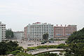 Hamhung |
1 | Pyongyang | Pyongyang Capital City | 3,255,288 | 11 | Sunchon | South Pyongan | 297,317 |  Chongjin  Nampo |
| 2 | Hamhung | South Hamgyong | 768,551 | 12 | Pyongsong | South Pyongan | 284,386 | ||
| 3 | Chongjin | North Hamgyong | 667,929 | 13 | Haeju | South Hwanghae | 273,300 | ||
| 4 | Nampo | South Pyongan Province | 366,815 | 14 | Kanggye | Chagang | 251,971 | ||
| 5 | Wonsan | Kangwon | 363,127 | 15 | Anju | South Pyongan | 240,117 | ||
| 6 | Sinuiju | North Pyongan | 359,341 | 16 | Tokchon | South Pyongan | 237,133 | ||
| 7 | Tanchon | South Hamgyong | 345,875 | 17 | Kimchaek | North Hamgyong | 207,299 | ||
| 8 | Kaechon | South Pyongan | 319,554 | 18 | Rason | Rason Special Economic Zone | 196,954 | ||
| 9 | Kaesong | North Hwanghae | 308,440 | 19 | Kusong | North Pyongan | 196,515 | ||
| 10 | Sariwon | North Hwanghae | 307,764 | 20 | Hyesan | Ryanggang | 192,680 | ||
| show Authority control |
|---|
- Hamhung
- Cities in South Hamgyong
- Port cities and towns in North Korea
- Socialist planned cities