Yodok County
This article needs additional citations for verification. (February 2022) |
Yodŏk County
요덕군 | |
|---|---|
| Korean transcription(s) | |
| • Hanja | 耀德郡 |
| • McCune-Reischauer | Yodŏk kun |
| • Revised Romanization | Yodeok-gun |
 Map of South Hamgyong showing the location of Yodok | |
| Country | North Korea |
| Province | South Hamgyong Province |
| Administrative divisions | 1 ŭp, 21 ri |
| Area | |
| • Total | 1,292 km2 (499 sq mi) |
| Population (2008[1]) | |
| • Total | 40,839 |
| • Density | 32/km2 (82/sq mi) |
Yodŏk County is a county in South Hamgyŏng province, North Korea. Originally part of Yŏnghŭng county (now Kŭmya County), it became a separate entity as part of the 1952 reorganization of local government.
Physical features[]
Most of the county is mountainous. Yodŏk is traversed by the Rangrim and ranges. The chief river is the . The highest point is Raganbong. Roughly 90% of the county's area is forestland.
Administrative divisions[]
Yodŏk county is divided into 1 ŭp (town) and 21 ri (villages):
|
|
Economy[]
Due to the rugged terrain, agriculture is nearly impossible. However, a few farms are tucked into the mountains, harvesting maize, soybeans, millet, wheat and barley.
Transport[]
Yodŏk county is served primarily by roads, but there is a single railway station on the P'yŏngra line of the Korean State Railway in Yodŏk-ŭp.
Camp[]
Yodŏk is the site of the Yodŏk concentration camp.
See also[]
References[]
External links[]
- (in Korean) In Korean language online encyclopedias:
| Capital | 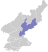 | |
|---|---|---|
| Cities | ||
| Districts | ||
| Counties | ||
Coordinates: 39°36′40″N 126°50′40″E / 39.61111°N 126.84444°E

- Counties of South Hamgyong