Chongpyong County
This article does not cite any sources. (January 2013) |
Chongpyong County
정평군 | |
|---|---|
| Korean transcription(s) | |
| • Chosŏn'gŭl | 정평군 |
| • Hancha | 定平郡 |
| • McCune-Reischauer | Chŏngp'yŏng kun |
| • Revised Romanization | Jeongpyeong-gun |
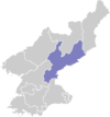
 Map of South Hamgyong showing the location of Chongpyong | |
| Coordinates: 39°45′0.00″N 127°19′59.99″E / 39.7500000°N 127.3333306°ECoordinates: 39°45′0.00″N 127°19′59.99″E / 39.7500000°N 127.3333306°E | |
| Country | North Korea |
| Province | South Hamgyong Province |
| Administrative divisions | 1 ŭp, 2 workers' district, 42 ri |

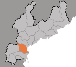
Chŏngp'yŏng County is a county in South Hamgyŏng province, North Korea. It borders South P'yŏngan province to the south, and the East Korea Bay to the east.
Physical features[]
The highest point is Noranbong. Most of the county's land is mountainous, but the southeast region is flat. The chief river is the . In the winter, its climate is continental and the weather is bitterly cold; however, the influence of the Rangrim Mountains makes Chŏngp'yŏng's climate milder than that of the Yellow Sea coast.
Administrative divisions[]
Chŏngp'yong county is divided into 1 ŭp (town), 2 rodongjagu (workers' districts) and 42 ri (villages):
|
|
Economy[]
Agriculture and fishery[]
Rice is cultivated on the level ground of the southeast, where the soil is fertile. Small amounts of other farming and orcharding also take place. Due to the county's coastal location, fishing is also practised.
Mining[]
Mining is a minor component of the local economy.
Transport[]
Chŏngp'yŏng county is served by the P'yŏngra Line of the Korean State Railway.
See also[]
External links[]
- (in Korean) In Korean language online encyclopedias:
| show Authority control |
|---|
- Counties of South Hamgyong