Hochon County
Hochon County
허천군 | |
|---|---|
| Korean transcription(s) | |
| • Hanja | 虛川郡 |
| • McCune-Reischauer | Hŏch'ŏn kun |
| • Revised Romanization | Heocheon-gun |
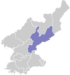
 Map of South Hamgyong showing the location of Hochon | |
| Coordinates: 40°45′57″N 128°33′15″E / 40.76583°N 128.55417°ECoordinates: 40°45′57″N 128°33′15″E / 40.76583°N 128.55417°E | |
| Country | North Korea |
| Province | South Hamgyong Province |
| Administrative divisions | 1 ŭp, 5 workers' districts, 17 ri |
| Area | |
| • Total | 1,684 km2 (650 sq mi) |
| Population (2008[1]) | |
| • Total | 104,731 |
| • Density | 62/km2 (160/sq mi) |
Hŏch'ŏn County is a county in South Hamgyŏng province, North Korea. It was created after the division of Korea, from portions of Tanch'ŏn and P'ungsan.
Geography[]
Most of the county is steep and mountainous, particularly in the southeast. There are numerous high peaks. The Pujŏllyŏng and (검덕산맥) pass through the county, with the highest peak at .
The chief stream is the Namdaech'ŏn. Approximately 90% of the county is forestland.
Administrative divisions[]
Hŏch'ŏn county is divided into 1 ŭp (town), 5 rodongjagu (workers' districts) and 17 ri (villages):
|
|
Economy[]
Mining and electrical power are the chief local industries. There are deposits of copper, iron ore, lead, and zinc. Local crops include maize, soybeans, and potatoes, but cultivation is difficult due to the mountainous terrain.
Sangnong mine is located in this county, to the west of Sangnong-rodongjagu.[2]
Transportation[]
Hŏch'ŏn county is served by the Hŏch'ŏn and Mandŏk lines of the Korean State Railway, and by various roads.
Near Sangnong-rodongjagu, there is a trolleybus line to Sangnong mine served by one vehicle, though there were two vehicles in 2002. However, in more recent satellite imagery from 2020, the only trolleybus visible has disappeared.[3]
See also[]
- Geography of North Korea
- Administrative divisions of North Korea
- South Hamgyong
References[]
- ^ North Korea: Administrative Division
- ^ "북한지역정보넷". www.cybernk.net. Retrieved 2021-02-05.
- ^ "Sangnong". transphoto.org. Retrieved 2021-02-07.
External links[]
- (in Korean) In Korean language online encyclopedias:
- Counties of South Hamgyong