Kanmon Roadway Tunnel
This article needs additional citations for verification. (August 2021) |
 | |
| Overview | |
|---|---|
| Line | |
| Location | Honshu-Kyushu |
| Coordinates | 33°57′48.6″N 130°57′33.6″E / 33.963500°N 130.959333°ECoordinates: 33°57′48.6″N 130°57′33.6″E / 33.963500°N 130.959333°E |
| Operation | |
| Opened | 1958 |
| Technical | |
| Line length | 3,461 m (11,355 ft) |
| Lowest elevation | 58 m below sea level |


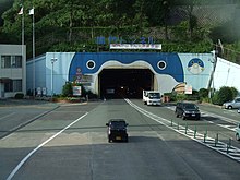
In Japan, the Kanmon Roadway Tunnel (関門国道トンネル, kanmon kokudō tonneru) carries National Route 2 under the Kanmon Straits.[1] At the time of its construction, it was the longest undersea road in the world.[citation needed] It opened in 1958. The overall length is 3,461 meters, and it is 58 meters below sea level at the deepest point.[citation needed] The endpoints are in Shimonoseki, Yamaguchi and Moji-ku, Kitakyūshū.[1]
Work on the Kanmon Roadway Tunnel began in 1937, but was halted in 1939 by World War II. Work resumed in 1952, and the tunnel was officially opened on March 9, 1958. The event was marked by a Japanese commemorative postage stamp. Major repairs were conducted in 2008.
Under terms of Article 46.3 of Road Act, driving by vehicles that carry dangerous goods are either prohibited or limited strictly.
Coordinates[]
- Shimonoseki entrance for cars: 33°58′30″N 130°56′51″E / 33.975115°N 130.947556°E
- Shimonoseki entrance for pedestrians and bicycles: 33°57′55″N 130°57′22″E / 33.965351°N 130.956028°E
- Moji entrance for cars: 33°57′05″N 130°58′08″E / 33.951385°N 130.968889°E
- Moji entrance for pedestrians and bicycles: 33°57′41″N 130°57′47″E / 33.961346°N 130.962944°E
References[]
- ^ a b 第2版,世界大百科事典内言及, 日本大百科全書(ニッポニカ),ブリタニカ国際大百科事典 小項目事典,百科事典マイペディア,精選版 日本国語大辞典,旺文社日本史事典 三訂版,デジタル大辞泉,世界大百科事典. "関門トンネルとは". コトバンク (in Japanese). Retrieved 2021-08-12.
This tunnel-related article is a stub. You can help Wikipedia by . |
- Tunnel stubs
- Road tunnels in Japan
- Undersea tunnels in Asia
- Roads in Yamaguchi Prefecture
- Roads in Fukuoka Prefecture