Karaka, New Zealand
This article needs additional citations for verification. (November 2015) |
Karaka | |
|---|---|
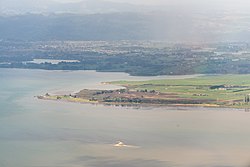 Aerial view of northern Karaka, with Papakura and the Hunua Ranges in the background. | |
 | |
| Country | New Zealand |
| Region | Auckland |
| Territorial authority | Auckland Council |
| Ward | Franklin Ward |
| Board | Franklin Local Board |
| Population (2018) | |
| • Total | 2,904 |
| Postcode | 2120 |
| Area code(s) | 09 |

Karaka is a small rural area in the south of Auckland, New Zealand. Formerly part of Franklin District and under the authority of the Franklin District Council, it is now part of Auckland Council (under the Franklin Local Board[1]) following the amalgamation of the Auckland region's councils.
To the west of Karaka is Kingseat, a small town where the former Kingseat Psychiatric Hospital was previously located. In 2005 the hospital was turned into a haunted attraction called Spookers.[2]
Demographics[]
| Year | Pop. | ±% p.a. |
|---|---|---|
| 2006 | 2,496 | — |
| 2013 | 2,550 | +0.31% |
| 2018 | 2,904 | +2.63% |
| Source: [3] | ||
The statistical area of Kingseat-Karaka, which at 87 square kilometres is much larger than this locality, had a population of 2,904 at the 2018 New Zealand census, an increase of 354 people (13.9%) since the 2013 census, and an increase of 408 people (16.3%) since the 2006 census. There were 936 households. There were 1,488 males and 1,416 females, giving a sex ratio of 1.05 males per female. The median age was 41.6 years, with 588 people (20.2%) aged under 15 years, 465 (16.0%) aged 15 to 29, 1,464 (50.4%) aged 30 to 64, and 390 (13.4%) aged 65 or older.
Ethnicities were 85.3% European/Pākehā, 13.9% Māori, 3.9% Pacific peoples, 7.0% Asian, and 1.9% other ethnicities (totals add to more than 100% since people could identify with multiple ethnicities).
The proportion of people born overseas was 16.1%, compared with 27.1% nationally.
Although some people objected to giving their religion, 52.4% had no religion, 34.8% were Christian, 0.6% were Hindu, 0.8% were Muslim, 0.6% were Buddhist and 3.6% had other religions.
Of those at least 15 years old, 522 (22.5%) people had a bachelor or higher degree, and 339 (14.6%) people had no formal qualifications. The median income was $44,200. The employment status of those at least 15 was that 1,284 (55.4%) people were employed full-time, 369 (15.9%) were part-time, and 60 (2.6%) were unemployed.[3]
Economy[]
Karaka is now primarily a rural town associated with thoroughbred horse studs, dairy farming and sheep farming. Karaka is the location of the thoroughbred yearling sales at New Zealand Bloodstock Karaka Sales Complex which is associated with the Karaka Million race meeting at Ellerslie. Westbury Stud and Haunui Farm are both located in Karaka.[4]
Traditionally the economy of Karaka was dominated by agriculture. However, following the transition to lifestyle blocks, the majority of residents now commute to urban Auckland for employment.
The Karaka Sports Park provides a local sports ground as well as bar and kitchen facilities. there are also a few small restaurants in the area. The Pukekohe Golf Club is located within the Karaka area bordering Pukekohe.
Marae[]
The Whātāpaka Marae and its meeting house, named Tamaoho, is a traditional meeting ground for local Māori. Three Waikato Tainui hapū are associated with the marae, primarily Ngāti Tamaoho, and secondarily Ngāi Tai and Ngāti Koheriki.[5][6]
Education[]
Karaka School and Te Hihi School are coeducational full primary schools (years 1–8) with rolls of 251 and 197 students, respectively.[7][8] Karaka School celebrated its 75th jubilee in 1978.[9] Te Hihi School opened in 1914.[10]
Rolls are as of November 2021.[11]
Public secondary education is provided in the nearby towns of Papakura and Pukekohe.
References[]
- ^ "Franklin Local Board". Retrieved 26 March 2013.
- ^ House of horrors at former hospital - Hospitals - NZ Herald News Retrieved December 2011
- ^ a b "Statistical area 1 dataset for 2018 Census". Statistics New Zealand. March 2020. Kingseat-Karaka (161400). 2018 Census place summary: Kingseat-Karaka
- ^ Karaka, New Zealand tourism.net.nz Retrieved December 2011
- ^ "Whātāpaka". Māori Maps. Te Potiki National Trust. Retrieved 24 August 2019.
- ^ "Ngāti Tamaoho: hapū and marae". Te Kāhui Māngai. Te Puni Kōkiri. Retrieved 24 August 2019.
- ^ Education Counts: Karaka School
- ^ Education Counts: Te Hihi School
- ^ "Collections record: A sense of history : Karaka School 75th jubilee, 3rd-5th March 1978". Auckland Museum. Retrieved 20 September 2020.
- ^ "Welcome to Te Hihi School". Te Hihi School. Retrieved 20 September 2020.
- ^ "New Zealand Schools Directory". New Zealand Ministry of Education. Retrieved 22 December 2021.
Coordinates: 37°6′S 174°52′E / 37.100°S 174.867°E

- Populated places in the Auckland Region
- Populated places around the Manukau Harbour
- Suburbs of Auckland