Kasese
Kasese | |
|---|---|
 | |
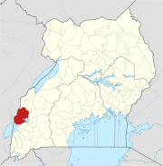
 Kasese Location in Uganda | |
| Coordinates: 0°11′12″N 30°05′17″E / 0.18667°N 30.08806°ECoordinates: 0°11′12″N 30°05′17″E / 0.18667°N 30.08806°E | |
| Country | |
| Region | Western Region |
| Sub-region | Rwenzururu region |
| District | Kasese District |
| Government | |
| • Mayor | Godfrey Kabbyanga |
| Elevation | 3,000 ft (1,000 m) |
| Population (2020 Estimate) | |
| • Total | 115,400 |
| Climate | Aw |

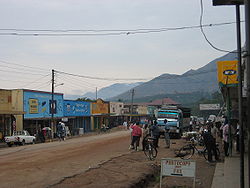
Kasese is a town north of Lake George in the Western Region of Uganda. It originally grew around the copper mine at Kilembe, while attention later turned to cobalt mining. It is the chief town of Kasese District, and the district headquarters are located there. Kasese is also the largest town in the Rwenzururu region. Charles Mumbere, the Omusinga of Rwenzururu, maintains a palace in the town.[1]
Location[]
Kasese is at the western end of the Uganda Railway to Kampala and Tororo and is home to Kasese Airport. The city is near the Rwenzori Mountains and Queen Elizabeth National Park. Kasese is locate approximately 370 kilometres (230 mi), by road, west of Kampala, Uganda's capital and largest city.[2]
This is about 60 kilometres (37 mi), by road, north-east of Mpondwe, the border town at the international border between Uganda and the Democratic Republic of the Congo (DRC).[3] The coordinates of Kasese are 0°11'12.0"N, 30°05'17.0"E (Latitude:0.186667; Longitude:30.088050).[4]
Population[]
The national census of 1969 enumerated the population of Kasese Town at 7,213 people. In 1980, the census that year put the population of the town at 9,917. In 1991, the national census numerated 18,750 inhabitants in Kasese. That population had increased to 85,697 people, according to the 2002 national census. On 27 August 2014, the census and national housing survey enumerated 101,065 people in Kasese Town Council.[5]
In 2020, the Uganda Bureau of Statistics (UBOS), estimated the mid-year population of the town at 115,400 inhabitants. UBOS calculated that the population of Kasese Municipality increased at an average rate of 2.3 percent annually, between 2014 and 2020.[5]
| Year | Pop. | ±% |
|---|---|---|
| 1969 | 7,213 | — |
| 1980 | 9,917 | +37.5% |
| 1991 | 18,750 | +89.1% |
| 2002 | 85,697 | +357.1% |
| 2014 | 101,065 | +17.9% |
| 2020 | 115,400 | +14.2% |
| source:[5] | ||
Population dynamics[]

During the 1990S Kasese Town was one of the fastest growing municipalities in Uganda. The reasons for this rapid population growth include:[6]
- Increased tourism - Kasese is the gateway to Queen Elizabeth National Park, one of the most popular in Uganda, and the Rwenzori National Park.[7]
- Kilembe Mines employs a large number of workers; over 3,000 as of January 2015.[8][9]
- Hima Cement Limited is another big employer located in Hima, approximately 24 kilometres (15 mi), by road, north of Kasese.[10]
- Increased trade with the eastern districts of the DRC. The border town of Mpondwe is only 60 kilometres (37 mi) south-west of Kasese.[3]
Industry[]
Kasese Cobalt Company Limited (KCCL), located on the road from Kasese to Rubirizi just south of the central business district of Kasese, extracts cobalt from the sludge left after copper is extracted from the raw ore.[8]
Points of interest[]

The following points of interest lie within the town or close to its edges:
- headquarters of Kasese District
- offices of Kasese town council
- Kasese central market
- branch of the National Social Security Fund
- Hima Cement Limited
- Kasese Airport
- Kilembe Cobalt Company Limited
- Kilembe Mines - Extraction of copper. Maintains a private hospital and a 5 megawatt mini-hydropower plant, Mubuku I Power Station, that supplies the town of Kasese.[11]
- Kilembe Mines Hospital - A 200-bed community hospital administered by Kilembe Mines Limited.[12][13][14]
See also[]
References[]
- ^ John F.S. Muwanga (Auditor General of Uganda) (10 December 2018). "Report Of The Auditor General On The Audit Of Financial Statements Of Kasese Municipal Council For The Year Ended 30h June 2018" (PDF). Office of the Auditor General of Uganda. Kampala, Uganda. Retrieved 18 August 2021.
- ^ Google (18 August 2021). "Road Distance Between Kampala, Uganda And Kasese, Uganda With Interactive Map" (Map). Google Maps. Google. Retrieved 18 August 2021.
- ^ Jump up to: a b Google (18 August 2021). "Road Distance Between Kasese, Western Region, Uganda and Mpondwe Customs Police Station, Western Region, Uganda" (Map). Google Maps. Google. Retrieved 18 August 2021.
- ^ Google (18 August 2021). "Location of Kasese Municipal Council, Western Region, Uganda" (Map). Google Maps. Google. Retrieved 18 August 2021.
- ^ Jump up to: a b c Uganda Bureau of Statistics (14 June 2020). "The population of all Ugandan cities and towns with more than 15,000 inhabitants according to census results and latest official projections". Citypopulation.de Quoting Uganda Bureau of Statistics. Retrieved 18 August 2021.
- ^ Alex Kwatampora Binego (10 January 2014). "Causes of River Nyamambwa floods". New Vision. Kampala. Retrieved 13 May 2016.
- ^ UWO (13 May 2016). "Rwenzori Mountains National Park: Tourism: "Kasese, 437 km west of Uganda's capital Kampala, is the gateway to the park"". Entebbe: Ugandawildlife.org (UWO). Archived from the original on 22 May 2016. Retrieved 13 May 2016.
- ^ Jump up to: a b Mugira, Fredrick (31 January 2015). "Chinese consortium to revive Uganda's copper mines". China Africa Reporting. Retrieved 13 May 2016.
- ^ Khisa, Isaac (10 January 2015). "Copper production to resume at Kilembe". The EastAfrican. Nairobi. Retrieved 13 May 2016.
- ^ GFC (13 May 2016). "Distance between Kasese, Western Region, Uganda and Hima, Western Region, Uganda". Globefeed.com (GFC). Retrieved 13 May 2016.
- ^ Asiimwe, Wilson (7 June 2014). "Kilembe mines rehabilitation starts". New Vision. Retrieved 13 September 2015.
- ^ Enid Ninsiima, and Thembo Kahungu Misairi (13 September 2015). "Four killed as floods sweep Kilembe Mines hospital". Daily Monitor. Kampala. Retrieved 1 July 2015.
- ^ Thawite, John (4 June 2013). "Kilembe Hospital re-opens". New Vision. Kampala. Retrieved 13 September 2015.
- ^ John Thawite, and Taddeo Bwambale (8 May 2014). "Five perish as fresh floods hit Kasese". New Vision. Kampala. Retrieved 13 September 2015.
External links[]
| Wikivoyage has a travel guide for Kasese. |
- Kasese Leaders Question Omission from Elevated Cities As of 29 May 2019.
- Kasese municipality records major leap in revenue collections As of 22 May 2021.
| show Authority control |
|---|
- Kasese District
- Rwenzururu sub-region
- Cities in the Great Rift Valley
- Populated places in Western Region, Uganda