Tororo
Tororo | |
|---|---|
 Storm in Tororo | |
 Tororo Location in Uganda | |
| Coordinates: 00°41′34″N 34°10′54″E / 0.69278°N 34.18167°E | |
| Country | |
| Region | Eastern Region of Uganda |
| District | Tororo District |
| Elevation | 4,193 ft (1,278 m) |
| Population (2014 Census) | |
| • Total | 41,906[1] |


Tororo is a town in the Eastern Region of Uganda. It is the main municipal, administrative, and commercial center of Tororo District. There are many shops, banks, supermarkets here. Tororo is a trading hub where many people come from the surrounding villages to work. There are a number of ATM's around town with one at Absa Bank accepting all major cards. MTN and Airtel mobile agents are throughout the town.there are a number of places of worship Destiny Family Church adjacent to Tororo Main Hospital is a Pentecostal Church.
History[]
Tororo was garrisoned by the Uganda Army's Air and Sea Battalion during the Uganda–Tanzania War (1978–79). On 2 March 1979, rebels loyal to Milton Obote attacked the town, whereupon part of the garrison defected while the rest was routed. Tororo was recaptured by the Uganda Army in a counter-attack two days later,[2][3] though many local civilians were displaced by the fighting.[4] A few weeks later, however, Amin's rule throughout Uganda collapsed and the garrison of Tororo mutinied yet again. This time, the remaining Amin loyalists were in no position to launch a counter-attack, and the mutineers subsequently handed over Tororo to the Uganda National Liberation Army (UNLA).[5]
Tororo was captured by the National Resistance Army in early February 1986 during the Ugandan Bush War. The UNLA counter-attacked in an attempt to retake Tororo and turn the tide in the war, but was repelled.[6]
Location[]
The town is approximately 10 kilometres (6.2 mi) west of the town of Malaba at the border between Uganda and Kenya. This is approximately 209 kilometres (130 mi), by road, east of Kampala, Uganda's capital and largest city.[7] The geographical coordinates of the town are 0°41'34.0"N, 34°10'54.0"E (Latitude:0.692780; Longitude:34.181655).[8] Tororo town lies at an average elevation of 1,278 metres (4,193 ft) above sea level.[9]
Population[]
In 2002, the national census put the population of the town of Tororo at about 34,800. In 2010, the Uganda Bureau of Statistics (UBOS) estimated the population at 42,500. In 2011, UBOS estimated the mid-year population at 43,700.[10] The 2014 national population census put the population at 41,906.[1]
Industry[]
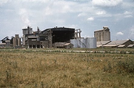
Tororo is home to three cement factories thus making Tororo the biggest producer of cement in the country. Tororo Cement Limited]], that in 2007, because of power shortages, could produce only 19,000 metric tonnes of cement daily against an installed capacity of 35,000 metric tonnes is the largest cement producer with 3 million tons produced annually. Tororo cement also produces nails, iron sheets, wire mesh among others.[11]
Larfage has also established their Hima Cement factory in Tororo producing variety of cement brands.[12]
Tororo has National cement company Uganda Limited (Simba brand), inaugurated in August 2018 and producing 2000 metric tonnes daily.[13]
It is also home to SEBA Foods, a food factory that was officially opened by the president of Uganda on 25 June 2010.[14]
Electromaxx Limited constructed a 20 megawatt thermal plant, Tororo Power Station, that was commissioned in June 2010.
Tororo is also the location of Nilefos Minerals Limited, a subsidiary of the Madhvani Group of companies. Nilefos mines and processes phosphates for use in fertilizer and related industries.[15]
There are a couple of new factories being constructed on the outskirts of the town. One factory is on the to way Busia is being built by a Chinese company.
Transport[]

Transport in and out of the town is well served by Matatus (privately owned minibuses). There are stages for Mbale (UGX 5,000) near the shell garage, Jinja (UGX 10,000) (including Iganga, and onward travel to Kampala) on Jinja road just past the roundabout.
Within town, Boda Bodas (motorbike taxis) are used for most journeys. These are cheap but not safe or regulated, caution should be used when travelling after rain or after dark. Journeys in and around town should cost between 500/= and 2,000/=.
Rail transport[]

Tororo marks the junction of railway lines to Pakwach, via Soroti, and to Kasese, via Kampala. Since 1993, the metre gauge line from Tororo Junction to Gulu and Pakwach has been out of use.
Rift Valley Railways funded the clearing of the line east to Gulu of vegetation and repairing track and bridges, thus allowing the first commercial train for 20 years to run through on the metre gauge track from the Kenyan port of Mombasa through Nairobi and Eldoret to the Kenyan frontier in Tororo and onwards to Gulu on the line to Pakwach on 14 September 2013.[16]
Climate and weather[]
Tororo has a tropical monsoon climate with a short dry season[17] The average annual temperature is 22.4 °C (72.3 °F) (average high 28.7 °C (83.7 °F) and average low 16.2 °C (61.2 °F)). Average annual precipitation is 1,494 millimetres (58.8 in).[18] Tororo has many thunderstorms and may be the place where thunder occurs on more days than any other place on Earth.[19] From September to December there is rain most days in the late afternoon. The drier and hotter season starts in December.
Points of interest[]
The following additional points of interest lie within the town limits or near its edges:
1. The tourist attraction of the town is the dominating rock outcrop that overlooks the town known as Tororo Rock. It is a hike that takes around an hour to the top. There used to be a cable car that took people to the top but this was closed down after a couple of people died in an accident. There is a fee for a tour guide at the bottom of the rock, just off the golf course.
2. There is a golf course in town with a clubhouse with a pool
3. Offices of Tororo Town Council
4. The Tororo central market was knocked down in September 2017, to make way for a new indoor shopping centre that is predicted to be finished in 2020. This has led to a new market starting nearby in Water Village.
5. Tororo General Hospital, a 200-bed public hospital administered by the Uganda Ministry of Health.
6. Uganda Martyrs' Cathedral, the seat of the archbishop of the Roman Catholic Archdiocese of Tororo
7. , a 150-bed mission hospital affiliated with the Roman Catholic Archdiocese of Tororo
8. Christ the King Priory, a Benedictine monastery of the Congregation of Missionary Benedictines of Saint Ottilien
9. Tororo–Mbale–Soroti Road[20] begins here and continues in a northwesterly direction, to end 158 kilometres (98 mi) away at Soroti.
10. Tororo Airport, a public airport administered by the Civil Aviation Authority of Uganda
11. Tororo Solar Power Station
12. Busitema University, one of the public universities in Uganda, located 28 kilometres (17 mi), by road, southwest of the central business district of Tororo town.
13. A mobile branch of PostBank Uganda
14. Branch of the National Social Security Fund.
Photos[]
- Photo of Tororo Rock 2
- Photo of Tororo Cement Works
- Photo of Rock Garden Hotel, Tororo
- Photo of Downtown Tororo

Tororo Rock Photo

See also[]
- Railway stations in Uganda
- Transport in Uganda
- Uganda Salvation Front
- List of cities and towns in Uganda
References[]
- ^ Jump up to: a b "The Population of The Regions of the Republic of Uganda And All Cities And Towns of More Than 15,000 Inhabitants". Citypopulation.de Quoting Uganda Bureau of Statistics (UBOS). 27 August 2014. Retrieved 26 February 2015.
- ^ Cooper & Fontanellaz 2015, p. 62.
- ^ Darnton, John (5 March 1979). "Amin's Rule in Uganda Imperiled As Tanzanian Force Nears Capital". New York Times. Retrieved 22 December 2018.
- ^ McManus, James (3 March 1979). "Amin's mutinous troops create a second front". The Guardian. Retrieved 22 December 2018.
- ^ Cooper & Fontanellaz 2015, p. 36.
- ^ Cooper & Fontanellaz 2015, p. 51.
- ^ Google (1 January 2021). "Distance between Post Office Building, Kampala Road, Kampala, Uganda and Tororo Post Office, Tororo, Uganda" (Map). Google Maps. Google. Retrieved 1 January 2021.
- ^ Google (26 February 2018). "Location of Tororo, Tororo District, Uganda" (Map). Google Maps. Google. Retrieved 26 February 2018.
- ^ "Tororo, Uganda Page". Falling Rain Software. 15 July 2019. Retrieved 15 July 2019.
- ^ "TP5: 2010 mid-year projected population for Town Councils" (PDF). Uganda Bureau of Statistics (UBOS). Retrieved 11 May 2014.
- ^ https://www.tororocement.com/. Missing or empty
|title=(help) - ^ https://www.lafarge.co.ug/1_1_1_2-History_AND_Background. Missing or empty
|title=(help) - ^ Kaujju, Peter (11 July 2007). "Cement shortage pushes retail price to sh25,000". New Vision. Retrieved 26 July 2015.
- ^ Ibrahim Kasita, Henry Mukasa and Moses Nampala (24 June 2010). "Power cuts to go - Museveni". New Vision. Retrieved 26 July 2015.
- ^ Ssonko, Kiganda (12 May 2008). "Madhvani to invest $535m in Tororo phosphates mining". New Vision. Retrieved 26 July 2015.
- ^ Staff Writers (9 October 2013). "Uganda's Northern Line revived". Railway Gazette International. Retrieved 26 July 2015.
- ^ "Average Weather in Tororo, Uganda". Weather Spark. Retrieved 6 July 2017.
- ^ "Climate Tororo - Uganda". climatedata.eu. Retrieved 6 July 2017.
- ^ "Top 10 facts about thunder". Daily Express. 6 June 2014. Retrieved 23 November 2016.
- ^ Sekanjako, Henry (25 July 2012). "Delayed Tororo-Mbale-Soroti road to cost more money". New Vision. Kampala. Retrieved 29 August 2015.
Works cited[]
- Cooper, Tom; Fontanellaz, Adrien (2015). Wars and Insurgencies of Uganda 1971–1994. Solihull: Helion & Company Limited. ISBN 978-1-910294-55-0.
External links[]
| Wikimedia Commons has media related to Tororo, Uganda. |
| Wikivoyage has a travel guide for Tororo. |
| Authority control |
|
|---|
Coordinates: 00°41′34″N 34°10′52″E / 0.69278°N 34.18111°E
| hide | ||
|---|---|---|
Capital: Tororo | ||
| Towns and villages |  | |
| Geography |
| |
| Economy | ||
| Banking | ||
| Energy | ||
| Health |
| |
| Transport |
| |
| Notable landmarks | ||
| Education | ||
| Notable people | ||
- Tororo
- Tororo District
- Populated places in Eastern Region, Uganda