Kep National Park
| Kep National Park | |
|---|---|
| Khmer: ឧទ្យានជាតិកែប | |
 Southeast Asia, Cambodia (green) | |
| Location | Kep, Cambodia |
| Coordinates | 10°30′22″N 104°18′29″E / 10.50614988°N 104.30800459°ECoordinates: 10°30′22″N 104°18′29″E / 10.50614988°N 104.30800459°E |
| Area | 66.64 km2 (25.73 sq mi)[1] |
| Established | 1993 |

Kep National Park is a national park in Cambodia's Kep Province that was established in 1993 and covers an area of 66.64 km2 (25.73 sq mi)[1] The nearest town lies at Krong Kaeb.
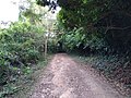
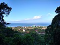
The park includes a small mountain range with tracks and trails which are popular with tourists.[citation needed] The trails boast incredible views of Phu Quoc and the Bokor Ranges on the south and west sides, and views across islands of the vast Vietnamese marine reserve in Kiên Giang to the east side.[2]
Gallery[]


References[]
- ^ Jump up to: a b c Protected Planet (2018). "Kep National Park". United Nations Environment World Conservation Monitoring Centre. Retrieved 26 Dec 2018.
- ^ Kiên Giang UNESCO-MAB Biosphere Reserve UNESCO
Sources[]
- Protected Areas and Development in The Lower Mekong River Region, .
- Kep National Park[permanent dead link] in the UNEP-WCMC World Database on Protected Areas (WDPA) from the World Conservation Monitoring Centre
External links[]
- "Kep, Cambodia". Kep-Cambodia.
This Cambodian location article is a stub. You can help Wikipedia by . |
Categories:
- IUCN Category II
- National parks of Cambodia
- Protected areas established in 1993
- Geography of Kep Province
- Tourist attractions in Kep Province
- Cambodia geography stubs