Ketchuptown, South Carolina
Ketchuptown, South Carolina | |
|---|---|
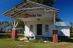 Country store at the crossroads | |
 Ketchuptown | |
| Coordinates: 34°06′08″N 79°09′19″W / 34.10222°N 79.15528°WCoordinates: 34°06′08″N 79°09′19″W / 34.10222°N 79.15528°W | |
| Country | United States |
| State | South Carolina |
| County | Horry |
| Established | 1920s |
| Area | |
| • Total | 2.71 sq mi (7.02 km2) |
| • Land | 2.71 sq mi (7.02 km2) |
| • Water | 0.0 sq mi (0.0 km2) |
| Elevation | 64 ft (20 m) |
| Population | |
| • Total | 84 |
| • Density | 31/sq mi (12.0/km2) |
| Time zone | Eastern |
| ZIP Code | 29581 (Nichols) |
| Area code(s) | 843 |


Ketchuptown is a historic unincorporated community and census-designated place (CDP) located in Horry County, South Carolina, United States. Ketchuptown is at the intersection of Highways 23 and 99, about 9 miles (14 km) north of Aynor. As of the 2020 census, it had a population of 84.[1]
Ketchuptown is a small homestead and farming community. During the 1920s farmers in the community would say to one another, "Lets go catch up on the news." Every Saturday afternoon would find them at a little country store in Ketchuptown. Highway 99 led east 16 miles (26 km) to Loris and southwest 8 miles (13 km) to Galivants Ferry. Cool Spring is approximately 10 miles (16 km) south on Highway 23.
References[]
- ^ a b "Ketchuptown CDP, South Carolina 2020 DEC Redistricting Data (PL 94-171)". U.S. Census Bureau. Retrieved January 24, 2022.
External links[]
- Ketchuptown (Horry County Board of Architectural Review)
- "Ketchuptown, 1927-1994; The Place To Catch Up On The News," by Ruth Ham (Horry County Historical Society)
Municipalities and communities of Horry County, South Carolina, United States | ||
|---|---|---|
| Cities |  | |
| Towns | ||
| CDPs |
| |
| Other communities | ||
| ||
This South Carolina state location article is a stub. You can help Wikipedia by . |
- Census-designated places in South Carolina
- Census-designated places in Horry County, South Carolina
- Unincorporated communities in South Carolina
- Unincorporated communities in Horry County, South Carolina
- South Carolina geography stubs