Kfar Yona
Kfar Yona
| |
|---|---|
City (from 2014) | |
| Hebrew transcription(s) | |
| • Also spelled | Kefar Yona (official) |
 | |
 Kfar Yona | |
| Coordinates: 32°19′1.57″N 34°56′8.74″E / 32.3171028°N 34.9357611°ECoordinates: 32°19′1.57″N 34°56′8.74″E / 32.3171028°N 34.9357611°E | |
| Country | |
| District | Central |
| Founded | 23 January 1932 |
| Government | |
| • Mayor | Shosh Kahlon |
| Area | |
| • Total | 11,017 dunams (11 km2 or 4 sq mi) |
| Population (2019)[1] | |
| • Total | 24,778 |
| • Density | 2,300/km2 (5,800/sq mi) |
| Website | http://kfar-yona.muni.il/ |


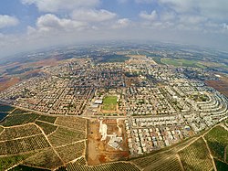
Kfar Yona (Hebrew: כְּפַר יוֹנָה, lit. 'Yona's Village') is a city in the Sharon subdistrict in the Central District of Israel. It is about 7 km east of Netanya.[2] With a jurisdiction of 11,017 dunams (~11 km²).[3] in 2019 it had a population of 24,778.[1] In 2014, Kfar Yona's official status was changed from a local council to a city.[4]
History[]

Kfar Yona was established on lands in the Sharon plain purchased in 1932 from Mustafa Bushnaq and the Shanti family of Qalqilya.[5]
Kfar Yona is named for Jean (Yona) Fischer, a Belgian Zionist.[6] It was founded on Tu Bishvat, January 23, 1932 by Morris Fischer, Yona's son, a member of the World Jewish Congress, and was originally named Gan Yona (Yona's Garden).


In the 1948 Arab-Israeli War, Kfar Yona was on the front lines, and its defenders faced the Iraqi Army, which sought to reach Netanya and cut the Jewish forces in Israel in half. The new Israel Defense Forces repelled the Iraqi attacks and forced them back into the Samarian mountains, although Kfar Yona remained the easternmost Jewish settlement in the area. As a result of the 1949 Armistice Agreements, the border moved from Kfar Yona 8 km eastward, to just west of Tulkarm.[6]
Kfar Yona was surrounded by orchards and its main income was from selling oranges. Most of these orchards are now the site of new neighborhoods.
Next to Kfar Yona is the Area 21 military base, named for Mota Gur, which includes paratroopers, Nahal, military police, and other small bases. In addition, Kfar Yona borders Pardesiya and the Lev HaSharon Regional Council.
Neighborhoods[]
Kfar Yona Alef[]

The original ten homes and the first community building. The homes are small, one-story, private structures, with an average of three rooms each. The community building stands today empty and is falling into ruin, though the town council is interested in maintaining it for its sentimental and historical value. Alef also includes a new neighborhood accessed from the western entrance to the village, with recently built family homes and more under construction. The main avenue of this section of Alef is a street where residents of the village can be found walking or jogging at any hour. For the past year, the west entrance has had a gate and guard that operates from 11pm to 6am. The whole village is policed by a volunteer guard force, supervised by a small professional security team, for which the town residents pay a small municipal tax.
Kfar Yona Bet[]

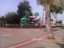
Cheaper apartment buildings, which are the first site of the village for visitors who enter from the eastern entrance. (Both entrances are on Highway 57, the eastern entrance is about 2 km further down the road than the western entrance, when driving from Highway 2, Israel's main Coastal Road). The east entrance is completely shut and locked from 11pm to 6am. Bet also includes the New Project, which are lower apartment buildings, with bigger homes. The New Project on Menachem Begin Street faces the City Council building, the Community Center (funded by Jewish Federation of Greater Vancouver sister-city fundraising activities), the community basketball courts and water park (also a gift from Vancouver), and the Hadar Elementary School (Grades 1-6). Beyond the New Project, Bet includes more expensive townhouses and private homes. It also includes the Betzali Park.
Heftziba[]
Down Menachem Begin Street is Heftziba named for the construction company that built it. On top of the hill is an old mansion that belonged an Arab who married a Jewish woman. Across Highway 57 is the new neighborhood of Alonim, also known as Kfar Yona Gimel. This neighborhood includes single-family homes, wide streetsand several parks
Sports and culture[]
The community center operates a music conservatory and holds public concerts. In 2006, 250 grade-school students participated in a basketball program. The older student's league has won championships. The community center holds classes in photography, ceramics, pottery and cooking.
Education[]
In 2010, Kfar Yona had 3 state schools, Hadar, Rimon and Amal, and a state-religious school, Bar Ilan. The town also has a junior high and high school, Ish Shalom.[7]
Transportation[]
Highway 57 is the main traffic artery connecting Kfar Yona to other localities and the national road system—Netanya to the west and Highway 6 to the east.
The city has no railway connection and since 2014 has been served by the Kavim bus company, which replaced Nateev Express.
Sister cities[]
 Vancouver, British Columbia, Canada[citation needed]
 New York City, New York, United States[citation needed]
Notable residents[]
References[]
- ^ Jump up to: a b "Population in the Localities 2019" (XLS). Israel Central Bureau of Statistics. Retrieved 16 August 2020.
- ^ Trans-Israel boost, Haaretz
- ^ "Local Authorities in Israel 2005, Publication #1295 - Municipality Profiles - Kfar Yona" (PDF) (in Hebrew). Israel Central Bureau of Statistics. Retrieved 2008-06-14.
- ^ "Kfar Yona Officially Israeli City". Arutz Sheva. 12 February 2014. Retrieved 1 May 2015.
- ^ Army of Shadows: Palestinian Collaboration with Zionism, 1917-1948, Hillel Cohen
- ^ Jump up to: a b Vilnai, Ze'ev (1976). "Kfar Yona". Ariel Encyclopedia (in Hebrew). Volume 4. Israel: Am Oved. p. 3756.
|volume=has extra text (help) - ^ Kfar Yona
External links[]
- Official website (in Hebrew)
| show Authority control |
|---|
- Central District (Israel)
- Cities in Central District (Israel)
- Cities in Israel
- Populated places established in 1932
- 1932 establishments in Mandatory Palestine