
Khalilabad, India
Khalilabad
खलीलाबाद خلیل آباد | |
|---|---|
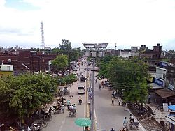 | |
 Khalilabad Location in Uttar Pradesh, India | |
| Coordinates: 26°47′N 83°04′E / 26.78°N 83.07°E | |
| Country | |
| State | Uttar Pradesh |
| District | Sant Kabir Nagar |
| Established | Jun 1860 |
| Founded by | Qazi Khalil-ur-Rahman (Representative of Aurangzeb Mughal emperor in this area at that time) |
| Named for | Qazi Khalil-ur-Rahman |
| Government | |
| • MP | |
| • MLA | |
| Area | |
| • Total | 26 km2 (10 sq mi) |
| Elevation | 69 m (226 ft) |
| Population (2011) | |
| • Total | 47,847 |
| • Density | 1,042/km2 (2,700/sq mi) |
| Demonym(s) | Khalilabadi |
| Languages | |
| • Official | Hindi, English, Urdu |
| • Regional | Bhojpuri |
| Time zone | UTC+5:30 (IST) |
| PIN | 272175 |
| Vehicle registration | UP-58 |
| Website | http://sknagar.nic.in/ |
Khalilabad (Hindi: खलीलाबाद, Urdu: خلیل آباد) is a city and a municipal board in Sant Kabir Nagar district in the Indian state of Uttar Pradesh. It is the district headquarters of Sant Kabir Nagar district.
Geography[]
Khalilabad lies on the Faizabad-Gorakhpur road and is around 36 km west of Gorakhpur and 36 km east of Basti. Khalilabad lies in Lat. 26 47'N. and Long. 83 4' E. This is the center point of Gorakhpur and Basti. It is the headquarters of this new district Sant Kabir Nagar.
The town is small but has a history which can be traced back to Mughal emperors. The place got its name from its founder, Qazi Khalil-ur-Rahman, who was appointed chakladar of Gorakhpur about 1860 AD.
At present this place is more famous for its handloom cloth market, popularly known as Bardahia Bazar. The tehsil building, situated to the south of the road to Gorakhpur, is an imposing structure created after the first freedom struggle in 1857 in which the place was sacked.
Climate[]
The climate of the district is more equable than the adjoining districts to the south. The year may be divided into four seasons. The winter season, from mid-November to February, is followed by the summer season lasting till about the middle of June. The period from mid-June to the end of September constitutes the south-west monsoon season. October to mid-November is the post-monsoon or transition period.
Rainfall: The average annual rainfall in the district is 1166 mm.
Temperature: During the winter seasons the mean minimum temperature is about 9 degrees Celsius and mean maximum is 23 degrees Celsius, while during the summer seasons the minimum is about 25 degrees Celsius and mean maximum is about 44 degrees Celsius.
Humidity: In the south-west monsoon and the post-monsoon seasons the relative humidity is high, above 70 percent. Thereafter the humidity decreases and in the summer the air is very dry.
Cloudiness: During the monsoon season, and for brief spells of a day or two in association with passing disturbances in winter, heavily clouded or overcast skies prevail. In the rest of the year, the skies are mostly clear or lightly clouded.
Winds: Winds are in general very light with a slight increase in force in the late summer and monsoon seasons. The average annual wind blow in the district ranges from 2 to 7.1 km/hrs.
River system and water resources[]
The Ami, the chief tributary of the Rapti, is a stream which commences at a short distance from Rapti in Rasulpur and issues from a large tract of paddy land.
The lakes of the district are numerous and several are of considerable size. They are most commonly formed by the changes in the river channels, while in other cases the natural depressions in which the surface of water collects, are generally due in some measure to fluvial action. The largest and the most celebrated lake in the district is the Bakhira or Badhanchh Tal, sometimes called the Moti Jhil, which lies on the eastern borders of the district between Bakhira and Mehdawal. This lake, though seldom more than two meters in depth, covers a very large area of about 12 km. long and 4 km. broad. The water in the lake is largely derived from the overflow from Rapti. Ghaghra popular as Saryu river, Kuano river and Kathinaiya river are also situated in the district.
Transport[]
Road[]
NH 27 and NH 28A pass through Khalilabad.(Ragadganj)
Railway[]
Railway Station Khalilabad is on the Gorakhpur-Lucknow line.
Airlines[]
The nearest airport is in Gorakhpur. Drive duration is approx 1 hour.
Gorakhpur to Delhi[]
| Airline | Departure (UTC +5:30) | Arrival (UTC +5:30) | Duration |
|---|---|---|---|
| Air India (AI-9810) | 16:15 | 18:15 | 2h Non Stop |
| SpiceJet (SG-8379) | 11:30 | 13:05 | 1h 35m Non Stop |
| Indigo (6E-138) | 10:30 | 12:35 | 2h 05m Non Stop |
Delhi to Gorakhpur[]
| Airline | Departure (UTC +5:30) | Arrival (UTC +5:30) | Duration |
|---|---|---|---|
| Air India (AI 9809) | 13:35 | 15:35 | 2h 00m Non Stop |
| SpiceJet (SG 8475) | 09:15 | 11:00 | 1h 45m Non Stop |
| Indigo (6E-826) | 08:50 | 09:30 | 40m Non Stop |
Gorakhpur to Mumbai[]
| Airline | Departure (UTC +5:30) | Arrival (UTC +5:30) | Duration |
|---|---|---|---|
| SpiceJet (SG-415) | 14:00 | 16:35 | 2h 35m Non Stop |
| SpiceJet (SG-453) | 16:20 | 18:50 | 2h 30m Non Stop |
| Indigo (6E-137) | 12:30 | 15:20 | 2h 50m Non Stop |
Mumbai to Gorakhpur[]
| Airline | Departure (UTC +5:30) | Arrival (UTC +5:30) | Duration |
|---|---|---|---|
| SpiceJet (SG-452) | 13:25 | 15:45 | 2h 20m Non Stop |
| SpiceJet (SG-438) | 10:55 | 13:20 | 2h 25m Non Stop |
| Indigo (6E-136) | 09:25 | 11:45 | 2h 20m Non Stop |
Educational Institutions[]
- Heeralal Ramnivas Post Graduate College
- Heeralal Ramnivas Intermediate College
- Rishikul Vidya Peeth
- Govt. Mahila Degree College
- Smt. Prabha Devi Mahavidyalaya
- St Xavier's School
- G.P.S. Mahavidyalaya
- St. Thomas Inter College
- Blooming buds Academy
- Surya International Academy
- Khalilabad Public School
- The Mindscape Academy
- PB Girls Inter College
- Govt Middle School
- Rajkiya Girls Inter College
- Maulana Azad Inter College
- RPS INTER COLLAGE
- Kudi Lal Rungta saraswati Vidya mandir
- Shiksha Niketan School
- ABRL Mahavidyalaya
- CANDID EDUCATION
- Basic education academy
Demographics[]
Khalilabad is a Nagar Palika Parishad city in district of Sant Kabir Nagar, Uttar Pradesh. The Khalilabad city is divided into 25 wards for which elections are held every 5 years. The Khalilabad Nagar Palika Parishad has population of 47,847 of which 25,154 are males while 22,693 are females as per report released by Census India 2011.
Population of Children with age of 0-6 is 6274 which is 13.11 % of total population of Khalilabad (NPP). In Khalilabad Nagar Palika Parishad, Female Sex Ratio is of 902 against state average of 912. Moreover Child Sex Ratio in Khalilabad is around 900 compared to Uttar Pradesh state average of 902. Literacy rate of Khalilabad city is 82.06 % higher than state average of 67.68 %. In Khalilabad, Male literacy is around 88.68 % while female literacy rate is 74.72 %.
Khalilabad Nagar Palika Parishad has total administration over 7,291 houses to which it supplies basic amenities like water and sewerage. It is also authorize to build roads within Nagar Palika Parishad limits and impose taxes on properties coming under its jurisdiction.
References[]
- Cities and towns in Sant Kabir Nagar district