Khamis Mushait
Khamis Mushayt
خميس مشيط | |
|---|---|
 | |
 Khamis Mushayt | |
| Coordinates: 18°18′N 42°44′E / 18.300°N 42.733°ECoordinates: 18°18′N 42°44′E / 18.300°N 42.733°E | |
| Country | |
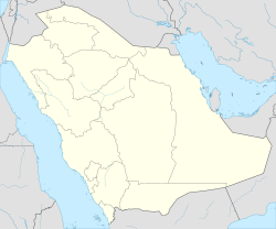
| Province | Asir |
| Government | |
| • Mayor | |
| Population (2017) | |
| • Total | 1,353,000 |
| Time zone | UTC+3 (EAT) |
| • Summer (DST) | UTC+3 (EAT) |
| Area code(s) | +966-17 |
| Website | Khamis Mushayt Municipality |

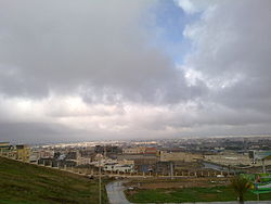
Khamis Mushayt or Khamis Mushait (Arabic: خميس مشيط, Ḫamīs Mušayṭ) is a city in south-west Saudi Arabia, located east of Abha, the provincial seat of the 'Asir Province, 1,300 kilometres (810 mi) 650 nautical miles from Dhahran and 884 kilometres (549 mi) from the national capital of Riyadh.[1] It is the capital of the Shahran tribe in the Asir region. It is fifth-largest city in Saudi Arabia after Riyadh, Jeddah, Mecca and Medina, with an estimated population of 1,353,000 as of 2017. Khamis Mushayt is noted for being the fourth largest trading center in Saudi Arabia, and is famous for its world-class military airbase.
History[]
Until the 1970s, Khamis Mushait was a small town of less than 50,000 servicing the surrounding mild-climate agricultural region. Since then its population has grown dramatically to reach over 1,200,000. The city is surrounded by farms producing agricultural crops.[2]
King Khalid Air Base (KMX) has a 12,400 ft (3,780 m) paved runway without customs facilities. The base was designed and built by US Army and Air Force engineers in the 1960s and 70s and has F-15 service facilities.[3] During the Gulf War in 1991, the US Airforce had a base here from which they launched bombers on Baghdad.[2]
Khamis Mushait was known by that name since the 1760s, it has been named after the market that used to be held on every Thursday of the week which is “Khamis” and it has been referred to Mushait Ibn Salem the head of Shahran tribe and the guardian of the market.[4][5]
Climate[]
Khamis Mushait has a hot desert climate (Köppen climate classification BWh), although its high altitude of 2,066 metres or 6,780 feet makes it less extreme than most of Arabia. For instance, Riyadh is around 7.4 °C or 13.3 °F hotter on average throughout the year, despite being about 670 kilometres or 420 miles further from the equator.
| hideClimate data for Khamis Mushait | |||||||||||||
|---|---|---|---|---|---|---|---|---|---|---|---|---|---|
| Month | Jan | Feb | Mar | Apr | May | Jun | Jul | Aug | Sep | Oct | Nov | Dec | Year |
| Average high °C (°F) | 20.0 (68.0) |
21.4 (70.5) |
23.0 (73.4) |
25.5 (77.9) |
28.1 (82.6) |
30.9 (87.6) |
30.0 (86.0) |
29.8 (85.6) |
28.9 (84.0) |
25.5 (77.9) |
23.0 (73.4) |
20.9 (69.6) |
25.6 (78.0) |
| Average low °C (°F) | 9.1 (48.4) |
8.0 (46.4) |
11.3 (52.3) |
12.5 (54.5) |
14.6 (58.3) |
16.3 (61.3) |
17.0 (62.6) |
17.3 (63.1) |
14.5 (58.1) |
11.1 (52.0) |
8.6 (47.5) |
7.2 (45.0) |
12.3 (54.1) |
| Average rainfall mm (inches) | 12 (0.5) |
27 (1.1) |
50 (2.0) |
52 (2.0) |
23 (0.9) |
5 (0.2) |
19 (0.7) |
28 (1.1) |
6 (0.2) |
2 (0.1) |
7 (0.3) |
4 (0.2) |
235 (9.3) |
| Source: Climate-data.org | |||||||||||||
Notable landmarks[]
Khamis Mushayt has several souks, including Khamis Souk and Silver Souq, both of which are noted for their silver jewellery, and Spice Souk.[2] Notable hotels include Mushayt Palace Hotel and Trident Hotel.[2] Also of note is Al-Hayat Hospital and Khamis Mushayt Mosque.

Al-Hayat Hospital

Statue of coffee in Heritage area of Khamis Mushait

King Fahd Mosque


References[]
- ^ Cordesman, Anthony H. (1987). Western Strategic Interests in Saudi Arabia. Croom Helm. p. 170. ISBN 978-0-7099-4823-0. Retrieved 27 August 2012.
- ^ Jump up to: a b c d Ham, Anthony; Shams, Martha Brekhus; Madden, Andrew (15 September 2004). Saudi Arabia. Lonely Planet. p. 134. ISBN 978-1-74059-667-1. Retrieved 27 August 2012.
- ^ Cordesman, Anthony H.; Al-Rodhan, Khalid R. (2007). Gulf Military Forces in an Era of Asymmetric Wars. Greenwood Publishing Group. p. 216. ISBN 978-0-275-99399-3. Retrieved 27 August 2012.
- ^ كتاب الشيخ سعيد بن عبدالعزيز ابن مشيط شيخ شمل قبائل شهران و ابنه عبدالعزيز في ذاكرة التاريخ
- ^ "Al Moqatel - خميس مشيط، المملكة العربية السعودية". Moqatel.com. Retrieved 2020-06-01.
| Wikimedia Commons has media related to Khamis Mushayt. |
| show |
|---|
| show Authority control |
|---|
- Populated places in 'Asir Province