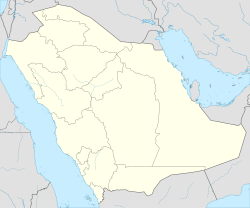
Tabuk, Saudi Arabia
Tabuk
تَبُوْك Tabouk | |
|---|---|
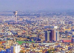 Skyline of Tabuk | |
 Tabuk | |
| Coordinates: 28°23′50″N 36°34′44″E / 28.39722°N 36.57889°ECoordinates: 28°23′50″N 36°34′44″E / 28.39722°N 36.57889°E | |
| Country | |
| Province | Tabuk province |
| Elevation | 760 m (2,490 ft) |
| Population (2020) | |
| • Total | 657,000 |
| Time zone | UTC+3 (AST) |
| Area code(s) | +966 14 |

Tabuk (Arabic: تَبُوْك Tabūk), also spelled Tabouk, is the capital city of the Tabuk Region in northwestern Saudi Arabia. It has a population of 657,000 (as of 2020). It is close to the Jordanian–Saudi Arabia border, and houses the largest air force base in Saudi Arabia.[1]
History[]
Ptolemy mentioned a place by the name 'Tabawa', at the northwestern corner of Arabia. This name may be a reference to 'Tabuka' or 'Tabuk'. If this is true, the town may be as old as Ptolemy's time. Pre-Islamic Arab poets, such as Antra and Nabiqa, mentioned its mountain 'Hasmi' in their poems.
Tabouk became famous for the Expedition to Tabuk in 630 CE, during the period of prophet Muhammad. Since then, it remained a gateway of North Arabia. It was also visited by a number of European travelers such as Doughty in 1877 and Huber in 1884.
Tabuk became a centre of military activity during the 1991 Gulf War as the city faced threats from Iraqi scuds and air attacks[citation needed].
Archaeological or historical sites in the area[]
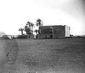
The region is rich in antiquities and archaeological sites such as petroglyphs, inscriptions, forts, palaces, walls, Syrian-Egyptian pilgrimage route, and the remains of the Hejaz Railway line, the main station of which is located in Tabuk.
Rock art and inscriptions' site in Wadi Dam[]
Hundreds of localities with Rock art and inscriptions dating to different chronological periods and ranging from Paleolithic to the Islamic period were recorded at Wadi Dam and the region west of Tabuk. Study of the art revealed rich stylistic variability and both human and animal figures were represented in it. Tens of sites in the area with Thamudic, Greek and Nabataean inscriptions have been found.
Tabuk Castle[]
It is also known as the castle of Aṣ-ḥāb al-Aykah (Arabic: أَصْـحَـاب الْأَيْـكَـة, "Companions of the Wood"), who are mentioned in the Quran.[2][3][4][5] The castle dates back to about 3500 BCE and has been restored many times; the last was in 1062 AH (1652 CE). It was one of the several forts and stations built along the Syrian pilgrimage route to welcome pilgrims. Several forts and stations were built along the road from the Jordanian border to Al-Medinah to welcome the pilgrims. The fort consists of two floors. The first floor contains an open courtyard and a number of rooms, a mosque, a well, and a stairway leading to the watch towers used by the guards. The fort is considered an archaeological landmark of the region and is open to visitors.
Ain Sukkrah[]
This is an ancient ‘ayn (Arabic: عـيـن, 'spring') dating to the Era of Jahiliyyah (Arabic: جَـاهـلـيّـة, 'Ignorance'). It is said that during the expedition of Tabuk, Muhammad camped more than ten days near the spring and drank from its water.[citation needed]
The Prophet's Mosque in Tabuk[]
It is also known as the Repentance Mosque. It was originally built with mud and roofed with palm trunk trees. It was restored in 1652. Eventually, its complete renewal was ordered by the late King Faisal ibn Abdul-Aziz, along the pattern of the Prophet's Mosque in Al-Medinah.
Education[]
Universities include:
Private schools include:
- British International School of Tabuk
Geography and climate[]

| hideClimate data for Tabuk, Saudi Arabia | |||||||||||||
|---|---|---|---|---|---|---|---|---|---|---|---|---|---|
| Month | Jan | Feb | Mar | Apr | May | Jun | Jul | Aug | Sep | Oct | Nov | Dec | Year |
| Average high °C (°F) | 18.1 (64.6) |
20.6 (69.1) |
24.6 (76.3) |
30.3 (86.5) |
34.4 (93.9) |
37.7 (99.9) |
38.9 (102.0) |
39.1 (102.4) |
36.9 (98.4) |
32.1 (89.8) |
25.1 (77.2) |
19.7 (67.5) |
29.8 (85.6) |
| Average low °C (°F) | 4.2 (39.6) |
5.9 (42.6) |
9.5 (49.1) |
14.4 (57.9) |
18.6 (65.5) |
21.6 (70.9) |
23.5 (74.3) |
23.6 (74.5) |
20.9 (69.6) |
16.4 (61.5) |
10.5 (50.9) |
5.6 (42.1) |
14.6 (58.3) |
| Average precipitation mm (inches) | 5.6 (0.22) |
1.3 (0.05) |
3.4 (0.13) |
2.7 (0.11) |
2.4 (0.09) |
0.3 (0.01) |
0.0 (0.0) |
0.7 (0.03) |
0.1 (0.00) |
5.0 (0.20) |
3.7 (0.15) |
4.4 (0.17) |
29.6 (1.17) |
| Source: "World Meteorological Organization".[6] | |||||||||||||
See also[]
- 1068 Near East earthquake, catastrophic event whose epicentre was in the area of Tabuk[7]
- Al-Hijr Archaeological Site (Hegra)
- AlUla
- Hejaz
References[]
- ^ Mackey, Sandra (2002), The Saudis: Inside the Desert Kingdom, New York: W.W. Norton and Company, p. 234, ISBN 0-393-32417-6 Updated Edition. Norton Paperback. First edition: 1987; Pbk.
- ^ Quran 15:78–79
- ^ Quran 26:176–189
- ^ Quran 38:13–15
- ^ Quran 50:12–14
- ^ "Tabuk Climate Normals". PME.
- ^ Ambraseys, N. N.; Melville, C. P.; Adams, R. D. (2005). The Seismicity of Egypt, Arabia and the Red Sea: A Historical Review. Cambridge University Press. pp. 30–32, 101. ISBN 978-0-521-02025-1.
External links[]
| Wikimedia Commons has media related to Tabuk. |
| show |
|---|
| hide Ottoman hajj routes | |||||||
|---|---|---|---|---|---|---|---|
| |||||||
| show Authority control |
|---|
- Tabuk, Saudi Arabia
- Populated places in Tabuk Province
- Provincial capitals of Saudi Arabia
- Jordan–Saudi Arabia border