Sakakah
This article needs additional citations for verification. (February 2012) |
Sakakah
سَكَاكَا | |
|---|---|
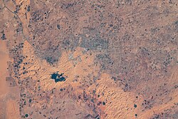 Sakakah seen from the International Space Station | |
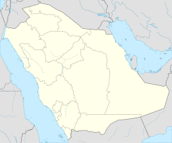 Sakakah Location in Saudi Arabia | |
| Coordinates: 29°58′11″N 040°12′00″E / 29.96972°N 40.20000°ECoordinates: 29°58′11″N 040°12′00″E / 29.96972°N 40.20000°E | |
| Country | |
| Province | Al Jawf |
| Area | |
| • Total | 100 km2 (40 sq mi) |
| Elevation | 566 m (1,857 ft) |
| Population (2010)[1] | |
| • Total | 242,813 |
| • Density | 2,400/km2 (6,300/sq mi) |

Sakākā (Arabic: سَكَاكَا) is a city in northwestern Saudi Arabia which is the capital of Al Jawf Province. It is located just to the north of the An Nafud desert. Sakakah had a population of 242,813 at the 2010 census.[1][2]
History[]
Sakakah is an oasis town on an ancient caravan route across the Arabian peninsula.
Modernization[]
In recent years, the Saudi government has been providing more seed capital to Al-Jawf region, especially in Sakaka in hopes of developing the economically starved region of the kingdom. For this reason, the city has new government buildings, schools and hospitals and are built adjacent to crumbling ruins of older buildings. One major feature of the city is the rapidly expanding Al Jouf University (Jami'at Al-Jawf), founded in 2005.[3] Sakaka is a small but expanding city with much construction in progress. A big ongoing project is the 1,000-bed Prince Muhammed Bin Abdulaziz Medical City which is under construction.
Education[]
The King hopes that Al Jouf University will become a pillar of social, cultural, and intellectual advancement in Saudi Arabia.[citation needed] There are several government-run schools and some private schools.[citation needed] The city has three English schools, Sakaka International School, which is an international, mostly Egyptian School and has CBSE curriculum, the other Al-Jouf International school with British curriculum and the third one is Alqimam international school with American curriculum.
Transportation[]
The city is served by Al-Jawf Airport which has domestic flights and flights to some of the major cities in the Middle East.
Agriculture[]
Al-Jawf is notable for its abundant agricultural water, making possible the cultivation of dates (200,000 palms) and olives (12,000,000 trees), as well as other agricultural products. Farms number around 16,000, and agricultural projects around 1,500. It is the home to agribusiness farms such as Watania Farms,[4] the largest organic farm in the kingdom. The fertile agricultural land of Al-Jawf is due largely to underground water, which drew delegates of King Abdul Aziz. They were sent to the town of Sakaka and Dumat Al-Jandal and Qurayat, requesting resident tribes there to join the nascent kingdom. Sakaka is home to many Saudi families that can proudly trace their lineage to a few large, old tribes that have dominated the area since time immemorial.
Historical Places[]
This section does not cite any sources. (July 2016) |

Rajajil standing stones sign Board
Omar Mosque in Dumat Al-Jandal

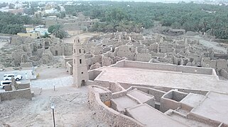
Mard Castle
The history of Al-Jawf dates back more than four thousand years. It is the home of many historic & prehistoric archaeological sites such Za'bal Castle & Well, the Omar ibn Al-Khattab Mosque, located in Dowmat Al-Jandal and Mard Castle (just south of Sakaka). There are also the ancient Rajajil standing stones in Sakaka, dating back nearly 6,000 years.[citation needed]
Climate[]
Köppen-Geiger climate classification system classifies its climate as hot desert (BWh).[5]
| hideClimate data for Sakakah (1985–2010) | |||||||||||||
|---|---|---|---|---|---|---|---|---|---|---|---|---|---|
| Month | Jan | Feb | Mar | Apr | May | Jun | Jul | Aug | Sep | Oct | Nov | Dec | Year |
| Record high °C (°F) | 30.3 (86.5) |
32.6 (90.7) |
36.3 (97.3) |
40.4 (104.7) |
42.6 (108.7) |
45.0 (113.0) |
47.7 (117.9) |
46.7 (116.1) |
45.2 (113.4) |
40.4 (104.7) |
37.5 (99.5) |
30.0 (86.0) |
47.7 (117.9) |
| Average high °C (°F) | 15.7 (60.3) |
18.4 (65.1) |
23.0 (73.4) |
29.1 (84.4) |
34.2 (93.6) |
38.3 (100.9) |
39.9 (103.8) |
40.7 (105.3) |
37.7 (99.9) |
31.8 (89.2) |
23.7 (74.7) |
17.6 (63.7) |
29.2 (84.6) |
| Daily mean °C (°F) | 9.7 (49.5) |
12.1 (53.8) |
16.4 (61.5) |
22.3 (72.1) |
27.4 (81.3) |
31.2 (88.2) |
32.8 (91.0) |
33.4 (92.1) |
30.3 (86.5) |
24.7 (76.5) |
17.2 (63.0) |
11.4 (52.5) |
22.4 (72.3) |
| Average low °C (°F) | 3.9 (39.0) |
5.7 (42.3) |
9.3 (48.7) |
14.6 (58.3) |
19.6 (67.3) |
22.7 (72.9) |
24.4 (75.9) |
24.9 (76.8) |
21.9 (71.4) |
17.4 (63.3) |
10.9 (51.6) |
5.6 (42.1) |
15.1 (59.2) |
| Record low °C (°F) | −6.0 (21.2) |
−7.0 (19.4) |
0.0 (32.0) |
1.0 (33.8) |
11.0 (51.8) |
15.0 (59.0) |
17.0 (62.6) |
18.8 (65.8) |
12.0 (53.6) |
6.5 (43.7) |
−1.4 (29.5) |
−4.4 (24.1) |
−7.0 (19.4) |
| Average precipitation mm (inches) | 13.2 (0.52) |
6.4 (0.25) |
5.9 (0.23) |
5.0 (0.20) |
1.8 (0.07) |
0.0 (0.0) |
0.0 (0.0) |
0.1 (0.00) |
0.6 (0.02) |
6.5 (0.26) |
7.2 (0.28) |
9.6 (0.38) |
56.3 (2.22) |
| Average precipitation days | 6.5 | 4.9 | 4.6 | 3.0 | 1.7 | 0.0 | 0.0 | 0.2 | 0.6 | 4.0 | 4.2 | 3.9 | 33.6 |
| Average relative humidity (%) | 57 | 45 | 35 | 27 | 19 | 15 | 16 | 16 | 19 | 28 | 41 | 53 | 31 |
| Source: Jeddah Regional Climate Center[6] | |||||||||||||
See also[]
- List of cities and towns in Saudi Arabia
- Sirhan Valley
References[]
- ^ Jump up to: a b "Saudi Arabia: Sakaka". Geohive. Archived from the original on 2013-08-28.
- ^ Taher, Mohamed (1998). Encyclopaedic Survey of Islamic Culture. Anmol Publications. ISBN 81-261-0403-1.
- ^ University of Al-Jouf website
- ^ Watania Farms website Archived 2011-02-07 at the Wayback Machine
- ^ "Climate: Sakaka - Climate graph, Temperature graph, Climate table". Climate-Data.org. Retrieved 2014-02-23.
- ^ "Climate Data for Saudi Arabia". Jeddah Regional Climate Center. Retrieved January 26, 2016.
External links[]
- A travel through the province of Al Jouf, Splendid Arabia: A travel site with photos and routes
- Rajajeel – Saudi Arabia's Stonehenge, nearby

| show |
|---|
| show Authority control |
|---|
- Populated places in Al-Jawf Province
- Geography of Saudi Arabia
- Provincial capitals of Saudi Arabia