Khulo
Khulo
ხულო | |
|---|---|
Townlet | |
 | |
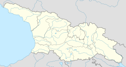 Khulo Location of Khulo in Georgia | |
| Coordinates: 41°38′40″N 42°18′50″E / 41.64444°N 42.31389°E | |
| Country | |
| Autonomous Republic | Adjara |
| District | Khulo |
| Daba from | 1964 |
| Population (2014) | |
| • Total | 1,007[1] |
| Time zone | UTC+4 (Georgian Time) |


Khulo (Georgian: ხულო [xulɔ]) is a townlet (daba) in Adjara, an autonomous republic in southwest Georgia, 88 km east of the regional capital Batumi, in the upper valley of Adjaris-tsqali. The town and adjoining 78 villages form the mountainous Khulo District (Rayon). Area – 710 km2; population – 23,327.[1]
The town, formerly known as Khula and Hulo, was a merchant place located on a medieval road that linked Samtskhe-Javakheti to the Black Sea coast. The Khulo area has been inhabited since ancient times, almost from the Bronze Age. Cult monuments such as the Thilvani Menhir, which is a simple megalith building-vertical column with height about 20 meters. Archaeologists think that it was connected to a funeral ritual. And also the Kaloto Altar have been found here, which confirm the existence of civilization in the Khulo region in pre-Christian times. The site was built up in the Middle Ages, as evidenced by the many surviving churches, castles, or medieval arched bridges.[2]
In the 16th century, the Ottoman Empire pursued an active policy of conquest in several regions of the world at once. Georgian lands became one of the directions of Ottoman expansion on the eastern coast of the Black Sea. However, the scattered parts of the former Georgian kingdom found themselves in the orbit of the Ottoman Empire's influence at different times, and the forms of their relations with the Ottoman state were also different. As the whole region of Adjara, Khulo was also part of the Ottoman Empire, during which the region was converted to Islam.[3]
During Ottoman times, Khulo was a chief settlement of Upper Adjara governed by the Khimshiashvili family. In 1829, it was briefly occupied by the Russian force of who sacked the Khimshiashvili residence before withdrawal.[4] Khulo's population, largely Islamized under the Ottomans, diminished dramatically under the Russian oppression of Islam in the 1870s. A series of floods and avalanches in the 1990s-2000s induced another wave of migration from the mountainous villages of the rayon.
In April 1929, during the Soviet rule, the Muslim villagers of mountainous Adjara rose in arms against compulsory collectivization and religious persecution. The Soviet troops were invoked and the revolt was quickly put down. Thousands of Adjarians were deported from the republic. [5]
Khulo district was established in 1965 by its current borders, and according to the current administrative-territorial arrangement, it is called Khulo municipality. [6]
In the district are medieval historical monuments - Khikhani Fortress (10th century) where rebel against Ottoman Empire Selim Beg Khimshiashvili was defending himself until he was captured and beheaded in 1785.[7] The exact date of building Khikhani fortress is unknown, but most of scientists think it was built in the X-XIII centuries. Khikhani fortress was one of the most important fortresses in Adjara. The castle is strategically located in a very convenient location, as it has one pedestrian access from the south-eastern side. It used to be a shelter for the local lords. [8] On the way to Khikhani fortress there is an active Monastery of Skhalta cathedral (13th century).
Besides historical monuments Khulo is also known by cable car Khulo Cable Car which is known to be the fastest way of transportation from Khulo to the village named Tago. This cable car is the second-longest free span cable car in Europe. [9]
See also[]
References[]
- ^ a b "Population Census 2014". www.geostat.ge. National Statistics Office of Georgia. November 2014. Retrieved 28 June 2021.
- ^ "History of Khulo". Glamping Tago Blog. 2021-03-19. Retrieved 2021-03-19.
- ^ "History of Khulo". Glamping Tago Blog. 2021-03-19. Retrieved 2021-03-19.
- ^ Allen, William Edward David & Muratov, Pavel Pavlovich (1953), Caucasian battlefields: a history of the wars on the Turco-Caucasian border, 1828-1921, p. 42. Cambridge University Press
- ^ "History of Khulo". Glamping Tago Blog. 2021-03-19. Retrieved 2021-03-19.
- ^ "History of Khulo". Glamping Tago Blog. 2021-03-19. Retrieved 2021-03-19.
- ^ "Khikhani Fortress". Glamping Tago Blog. 2021-03-19. Retrieved 2021-03-19.
- ^ "History of Khulo". Glamping Tago Blog. 2021-03-19. Retrieved 2021-03-19.
- ^ "Khulo Cable Car". Glamping Tago Blog. 2021-03-19. Retrieved 2021-03-19.
Coordinates: 41°39′N 42°19′E / 41.650°N 42.317°E
Cities, towns and townlets in Georgia | ||
|---|---|---|
| Autonomous Republic of Abkhazia |   | |
| Autonomous Republic of Adjara | ||
| Guria | ||
| Imereti | ||
| Kakheti | ||
| Mtskheta-Mtianeti | ||
| Samegrelo-Zemo Svaneti | ||
| Samtskhe-Javakheti |
| |
| Racha-Lechkhumi and Kvemo Svaneti | ||
| Kvemo Kartli | ||
| Shida Kartli | ||
| Cities with local government | ||
| Capital city | ||
This Georgia location article is a stub. You can help Wikipedia by . |
- Cities and towns in Adjara
- Batum Oblast
- Georgia (country) geography stubs