Akhalkalaki
Akhalkalaki
ახალქალაქი | |
|---|---|
Town | |
 | |
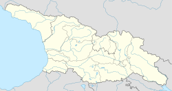 Akhalkalaki Location of Akhalkalaki in Georgia | |
| Coordinates: 41°24′20″N 43°29′10″E / 41.40556°N 43.48611°ECoordinates: 41°24′20″N 43°29′10″E / 41.40556°N 43.48611°E | |
| Country | |
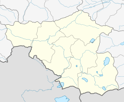
| Mkhare | Samtskhe-Javakheti |
| District | Akhalkalaki |
| Elevation | 1,707 m (5,600 ft) |
| Population (2014)[1] | |
| • Total | 8,295 |
| Time zone | UTC+4 (Georgian Time) |
| Website | Official |

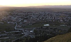
Akhalkalaki (Georgian: ახალქალაქი, romanized: akhalkalaki; Armenian: Ախալքալաք / Նոր-Քաղաք, romanized: Axalk’alak’ / Nor-K’aġak’; Turkish: Ahılkelek) is a town in Georgia's southern region of Samtskhe–Javakheti and the administrative centre of the Akhalkalaki Municipality. Akhalkalaki lies on the edge of the Javakheti Plateau. The city is located about 30 kilometres (19 mi) from the border with Turkey. The town's recorded history goes back to the 11th century. As of the 2014 Georgian census the town had a population of 8,295, with an overwhelming Armenian majority.[1]
Etymology[]
The name Akhalkalaki, first recorded in the 11th-century Georgian chronicle,[2] means "a new town", from Georgian [ɑxɑli], "new", and [kʰɑlɑkʰi], "city" or "town". Its Armenian and Turkish names, Akhalakak and Ahılkelek, respectively, are transcribed from the Georgian. The 19th-century ethnographic accounts have another Armenian name for the town, Nor-Kaghak, also meaning "a new town".[3]
History[]
Akhalkalaki was founded by Bagrat IV of Georgia in 1064.[citation needed] In 1066, the city was destroyed during the Seljuq invasions of the Kingdom of Georgia.[4] In the 11th century Akhalkalaki became one of the political and economical centres of Javakheti. In the 16th century the city came under the rule of the Ottoman Empire and became a sanjak centre in Çıldır Eyaleti. Under the Ottoman rule, the town was known as "Ahılkelek". The city was passed from the Ottomans to the Russians after the Russo-Turkish War in 1828–1829. On January 4, 1900, an earthquake destroyed much of the town and killed 1,000 people in the area.[5] The citizens predominantly dwelled in dugouts till the 1920s.[6]
Population[]
By the time of the region's annexation to the Russian Empire in 1829, the population was mainly Islamicized Georgians.[7] After the Russian takeover most of the Muslim Georgians left the area for the Ottoman Empire and in their place Christian Armenian refugees from Erzurum and Bayazid settled here.[7] Since then the city and the region of Javakheti has been largely populated by Armenians.
| Year | Armenians | Georgians | Russians | Total | |||
|---|---|---|---|---|---|---|---|
| 1886 | 4,083 | 94.9% | 51 | 1.2% | 57 | 1.3% | 4,303 |
| 1897[9] | 4,136 | 76% | 129 | 2.4% | 479 | 8.8% | 5,440 |
| 1926[10] | 3,185 | 90.9% | 197 | 5.7% | 61 | 1.8% | 3,475 |
| 1959[11] | 6,522 | 74.1% | 433 | 4.9% | 1,424 | 16.2% | 8,804 |
| 1979[12] | 11,879 | 89.8% | 506 | - | 563 | - | 13,224 |
| 1989[13] | - | - | - | - | - | - | 15,572 |
| 2014[14] | 7,782 | 93.8% | 471 | - | 18 | - | 8,295 |
Climate[]
The climate of Akhalkalaki is moderately humid with relative cold dry winters and long cool summers. (Köppen: Dfb)
| hideClimate data for Akhalkalaki | |||||||||||||
|---|---|---|---|---|---|---|---|---|---|---|---|---|---|
| Month | Jan | Feb | Mar | Apr | May | Jun | Jul | Aug | Sep | Oct | Nov | Dec | Year |
| Average high °C (°F) | −1.9 (28.6) |
−0.9 (30.4) |
3.3 (37.9) |
9.9 (49.8) |
15 (59) |
18.6 (65.5) |
21.8 (71.2) |
22.3 (72.1) |
18.8 (65.8) |
13.4 (56.1) |
6.2 (43.2) |
0.4 (32.7) |
10.6 (51.0) |
| Daily mean °C (°F) | −7.3 (18.9) |
−6.3 (20.7) |
−1.8 (28.8) |
4.1 (39.4) |
9 (48) |
12.1 (53.8) |
15.1 (59.2) |
15.3 (59.5) |
11.4 (52.5) |
6.8 (44.2) |
1 (34) |
−4.3 (24.3) |
4.6 (40.3) |
| Average low °C (°F) | −12.6 (9.3) |
−11.7 (10.9) |
−6.9 (19.6) |
−1.6 (29.1) |
3 (37) |
5.6 (42.1) |
8.5 (47.3) |
8.4 (47.1) |
4.1 (39.4) |
0.2 (32.4) |
−4.2 (24.4) |
−8.9 (16.0) |
−1.3 (29.6) |
| Average precipitation mm (inches) | 24 (0.9) |
31 (1.2) |
32 (1.3) |
57 (2.2) |
92 (3.6) |
97 (3.8) |
59 (2.3) |
56 (2.2) |
41 (1.6) |
44 (1.7) |
40 (1.6) |
27 (1.1) |
600 (23.5) |
| Source: Climate-Data.org[15] | |||||||||||||
Transport[]
The crossroads village meets from south the streets from the border to Armenia and Turkey, from north to Borjomi–Gori and east–west from Batumi to Tiflis south of the Lesser Caucasus.
A 160 kilometres (99 mi) long railway line was constructed between 1982 and 1986 in three parts. The junction from the line Tbilisi–Yerevan is in Marabda.
In April 2005, an agreement was signed to build a new railway connecting Turkey with Georgia and Azerbaijan, passing nearby Akhalkalaki. This would bypass an existing line through Gyumri in Armenia which has been closed by Turkey, blockading Armenia, for political reasons since the 1990s.[16] The railway became operational on October 30, 2017.[17] It is here where the break-of-gauge is.[18]
In compound with the military base was constructed an airport.[1] With military dismantling it was closed.
Bases[]

The city was home to the Soviet-era 147th Motor Rifle Division (part of the 9th Army of the Transcaucasian Military District) up until the early 1990s. After the fall of the Soviet Union the Division became the Russian 62nd Military Base. It was officially transferred, according to the Sochi agreement, to Georgia on June 27, 2007.[19]
On September 19, 2020, a new basic combat training center was opened on the site of the former base in Akhalkalaki. The center is designed to accommodate and train up to 800 military personnel and conscripts.[20]
Notable people[]
- Derenik Demirchian, Armenian writer
- Jivani, Armenian bard
- Harutyun Khachatryan, Armenian film director
- Ruben Ter-Minasian, Defense Minister of the First Republic of Armenia
- Hamo Ohanjanyan, the third Prime Minister of the First Republic of Armenia
- Ahmed bey Pepinov, Azerbaijani statesman
- Aik Mnatsakanian, Armenian wrestler representing Bulgaria
- Hakob Hakobyan, professional football player
See also[]
References[]
- ^ Jump up to: a b "Population Census 2014". www.geostat.ge. National Statistics Office of Georgia. November 2014. Retrieved 28 June 2021.
- ^ Kartlis Tskhovreba. Istoria Gruzii. Artanudzhi, Tbilisi, 2008, 454 p. (In Russian)
- ^ "181 Царь Картли Вахтанг VI. Комментарии". Восточная литература.
- ^ Suny, Ronald Grigor (1994), The Making of the Georgian Nation: 2nd edition. Indiana University Press, p. 34
- ^ The Annual Register of World Events, 1900 (Longmans, Green, and Co., 1901) p461
- ^ Закарая, П. (1983) Памятники Восточной Грузии. Искусство, Москва, 376 с. [Zakaraya, P. Monuments of Eastern Georgia](In Russian)
- ^ Jump up to: a b Richard G. Hovannisian (1971). The Republic of Armenia: The first year, 1918-1919. University of California Press. p. 70. ISBN 978-0-520-01805-1.
- ^ "население грузии". Retrieved October 8, 2016.
- ^ "АХАЛКАЛАКСКИЙ УЕЗД (1897 г.)". Retrieved October 8, 2016.
- ^ "Ахалкалакский уезд 1926". www.ethno-kavkaz.narod.ru. Retrieved 21 April 2018.
- ^ "Ахалкалакский район 1959". www.ethno-kavkaz.narod.ru. Retrieved 21 April 2018.
- ^ "Ethnic composition of Georgia 1979".
- ^ "Archived copy". Archived from the original on 2006-10-21. Retrieved 2013-05-16.CS1 maint: archived copy as title (link)
- ^ http://pop-stat.mashke.org/georgia-ethnic-loc2014.htm
- ^ "Akhalkalaki climate". Climate-Data.org.
- ^ Railway Gazette International February 2009, p54
- ^ "Baku-Tbilisi-Kars (BTK) railway track becomes operational to carry Chinese goods to Europe". dnd.com.pk. 30 October 2017. Retrieved 27 February 2018.
- ^ Ltd, DVV Media International. "Stadler signs Baku – Tbilisi – Kars sleeping car contract". railwaygazette.com. Retrieved 21 April 2018.
- ^ Russia Transfers Akhalkalaki Military Base to Georgia. Archived 2012-02-06 at the Wayback Machine Civil Georgia. June 27, 2007. Accessed on June 29, 2007.
- ^ "New primary combat training center opened in Akhalkalaki". www.1tv.ge. The Georgian Public Broadcaster. Retrieved 5 August 2021.
External links[]
| Wikimedia Commons has media related to Akhalkalaki. |


| Authority control |
|
|---|
- Cities and towns in Samtskhe–Javakheti
- Tiflis Governorate
- Armenian diaspora communities