Kinneret (archaeological site)
Coordinates: 32°51′38″N 35°30′26″E / 32.86056°N 35.50722°E

Kinneret (Hebrew: כִּנֶּרֶת) is the name of an important Bronze and Iron Age city situated on the northwestern shore of the Sea of Galilee, mentioned in the 14th century BC Aqhat Epic of Ugarit, and in the Old Testament and New Testament. Older Bible translations spell the name alternatively Kinnereth or Chinnereth, and sometimes in the plural as Chinneroth.[1][2] In time the name became Gennesaret and Ginosar (Hebrew: גִּנֵּיסַר). The remains of Kinneret have been excavated at a site called Tell el-'Oreimeh in Arabic and Tel Kinrot in Modern Hebrew.
Etymology[]
"Kinneret"[]
Talmud[]
According to the Jerusalem Talmud (Megillah 1:1), the name Kinneret is derived from the name of the kinnar trees which grow in its vicinity, explained by lexicographer M. Jastrow to mean the Christ's thorn jujube (Ziziphus spina-christi),[3] and by Moses Margolies to mean cane reeds.[4]
Another Talmud passage says that it is so-called because its fruits[dubious ] are as sweet as those of the kinnara[dubious ] (Ziziphus spina-christi).[5][dubious ]
"Gennesaret" and "Ginosar"[]
Kinneret, in the plural Kinnerot, was Grecized to Gennesaret, and Ginosar is yet another transformation of the name.[6]
Historical use of the name[]
The lake[]
Due to its prominence, the city gave its name to the lake (the "Sea of Galilee") for long periods of history, as the Sea of Kinneret, Kinnerot, Gennesaret, or Ginosar.[6]
As other places around the lake rose to prominence, such as Tiberias and Qasr al-Minya, the name of the lake also changed to Lake Tiberias or Lake Minya.
The plain[]
The name has also been used for the "Plain of Gennesaret", which stretches south of the ancient city. The plain's modern names are Plain of Ginosar in Hebrew and el-Ghuweir in Arabic.
Modern settlements[]
The Israeli kibbutz Ginosar derives its name from the ancient town, though it is not located on its precise site. The settlements of Moshavat Kinneret and Kvutzat Kinneret are even further south, on the southwestern shore of the lake.
Biblical and other ancient sources[]
Annals of Thutmose III[]
| ||||||
| knnꜣrtw[7][8] | ||||||
|---|---|---|---|---|---|---|
| Era: New Kingdom (1550–1069 BC) | ||||||
| Egyptian hieroglyphs |
Kinneret is mentioned as Kennartou in the 15th-century BCE Annals of Thutmose III at Temple of Karnak.[7]
Hebrew Bible[]
Kinneret was a town allotted to the tribe of Naphtali (Joshua 19:35). The name appears in the singular form as "Kinneret" (Numbers 34:11, Deuteronomy 3:17) or in the plural as "Kinneroth" (Joshua 11:2, 12:3).
New Testament Gospels[]
In the New Testament the name appears changed to Gennesaret (Luke 5:1).
This city or area is also a place where Jesus visited and performed healing (Matthew 14:34; Mark 6:53). The Douay-Rheims Bible uses the form "Genesar", see Gospel of Matthew
- [34] And having passed the water, they came into the country of Genesar. (Matthew 14:34).
Josephus and Babylonian Talmud[]
Flavius Josephus, as well as the Babylonian Talmud mention the lake by the name "Sea of Ginosar" after the small fertile plain of Ginosar that lies at the foot of Tell el-'Oreimeh, ancient Kinneret. Josephus refers to the area as having very rich soil.[9]
Identification and location[]

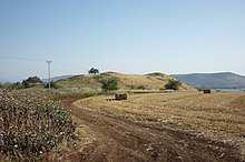
The site of the fortified Bronze and Iron Age city of Kinneret is identified with the mound known in Arabic as Tell el-'Oreimeh and in modern Hebrew as Tel Kinrot, halfway between Capernaum and Magdala.[10][11] Situated on an important trade route, its elevated position meant that it also overlooked and guarded the Plain of Ginosar from its northern end.
The site has the ICS Coordinates: 200805-1252830;[12][13][14] ca. 32.87000 N, 35.539312 E.[14]
Archaeological exploration[]
The tell is being excavated as part of a large archaeological project which is ongoing since 2002.[15]
See also[]
References[]
- ^ "Bible Hub, Chinneroth". biblehub.com. Retrieved 2018-11-06.
- ^ Arnold, Bill T.; Beyer, Bryan E. (2002). Readings from the Ancient Near East: Primary Sources for Old Testament Study. Baker Academic. p. 82. ISBN 978-0-8010-2292-0.
- ^ Marcus Jastrow, Dictionary of the Targumim, the Talmud Babli and Yerushalmi, and the Midrashic Literature, Peabody, Mass. 2006, p. 651 (s.v. כנרא)
- ^ Jerusalem Talmud, Megillah 1:1 [2b]
- ^ Babylonian Talmud (Megillah 6a)
- ^ Jump up to: a b Easton's Revised Bible Dictionary, "Gennesaret"
- ^ Jump up to: a b Gauthier, Henri (1928). Dictionnaire des Noms Géographiques Contenus dans les Textes Hiéroglyphiques Vol. 5. p. 205.
- ^ Wallis Budge, E. A. (1920). An Egyptian hieroglyphic dictionary: with an index of English words, king list and geological list with indexes, list of hieroglyphic characters, Coptic and Semitic alphabets, etc. Vol II. John Murray. p. 1048.
- ^ The Physical Geography, Geology, and Meteorology of the Holyand by Henry Baker Tristram 2007 ISBN 1593334826 page 11
- ^ Avraham Negev, Shimon Gibson, ed. (2001). Archaeological Encyclopedia of the Holy Land. New York, London: Continuum. p. 285. ISBN 0-8264-1316-1.
- ^ Lamar Williamson 1983 Mark ISBN 0804231214 pages 129-130
- ^ Aharoni, Yochanan. The Land of the Bible, A Historical Geography. The Westminster Press, Philadelphia, 1979, p. 433.
- ^ "עמוד ענן - המדריך השיתופי לידיעת הארץ". amudanan.co.il (in Hebrew). Retrieved 2018-11-06.
- ^ Jump up to: a b Clément RONZON. "TWCC, The World Coordinate Converter". twcc.free.fr. Retrieved 2018-11-06.
- ^ "Tel Kinrot – Kinneret Regional Project". kinneret-excavations.org. Retrieved 2018-11-06.
External links[]
| Wikimedia Commons has media related to Tel Kinarot. |
| Authority control |
|
|---|
- New Testament places
- Hebrew Bible places
- Former populated places in Southwest Asia
- Tells (archaeology)