Kinnikinnick, Ohio
Kinnikinnick, Ohio | |
|---|---|
 Kinnikinnick, Ohio | |
| Coordinates: 39°25′33″N 82°57′10″W / 39.42583°N 82.95278°WCoordinates: 39°25′33″N 82°57′10″W / 39.42583°N 82.95278°W | |
| Country | United States |
| State | Ohio |
| County | Ross |
| Elevation | 666 ft (203 m) |
| Time zone | UTC-5 (Eastern (EST)) |
| • Summer (DST) | UTC-4 (EDT) |
| Area code(s) | 740 |
| GNIS feature ID | 1058188[1] |

Kinnikinnick is an unincorporated community in Ross County, Ohio, United States. Kinnikinnick is located at the junction of Ohio State Route 159 and Ohio State Route 180, 16.6 miles (26.7 km) north-northeast of Chillicothe.[2]
History[]
A post office called Kinnikinnick was established in 1878, and remained in operation until 1910.[3] The community takes its name from Kinnikinnick Creek, which the community is located on.[4]
Gallery[]
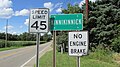
Kinnikinnick community sign.
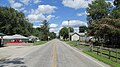
Looking east on Ohio Highway 180 in Kinnikinnick.


References[]
- ^ "Kinnikinnick". Geographic Names Information System. United States Geological Survey.
- ^ Official Transportation Map (PDF) (Map). Ohio Department of Transportation. 2011. Retrieved February 1, 2013.
- ^ "Ross County". Jim Forte Postal History. Retrieved 3 January 2016.
- ^ Overman, William Daniel (1958). Ohio Town Names. Akron, OH: Atlantic Press. p. 70.
Municipalities and communities of Ross County, Ohio, United States | ||
|---|---|---|
| City |  | |
| Villages | ||
| Townships | ||
| CDPs | ||
| Unincorporated communities | ||
| Ghost town | ||
| Footnotes | ‡This populated place also has portions in an adjacent county or counties | |
| ||
This Ross County, Ohio state location article is a stub. You can help Wikipedia by . |
Categories:
- Unincorporated communities in Ross County, Ohio
- Unincorporated communities in Ohio
- 1878 establishments in Ohio
- Columbus metropolitan area, Ohio geography stubs