Ko Yao District
Ko Yao
เกาะยาว | |
|---|---|
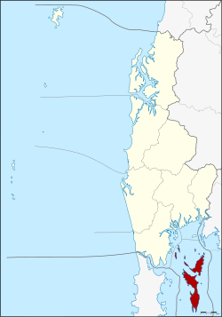 District location in Phang Nga Province | |
| Coordinates: 8°6′42″N 98°35′27″E / 8.11167°N 98.59083°ECoordinates: 8°6′42″N 98°35′27″E / 8.11167°N 98.59083°E | |
| Country | Thailand |
| Province | Phang Nga |
| Seat | Ko Yao Noi |
| District established | 1903 |
| Area | |
| • Total | 141.06 km2 (54.46 sq mi) |
| Population (2008) | |
| • Total | 13,155 |
| • Density | 90.3/km2 (234/sq mi) |
| Time zone | UTC+7 (ICT) |
| Postal code | 82160 |
| Geocode | 8202 |

Ko Yao (Thai: เกาะยาว, pronounced [kɔ̀ʔ jāːw]) is a district (amphoe) in Phang Nga Province in Thailand's south.
History[]
Early history[]
Numerous cave paintings hidden around Ko Yao Island date back more than 2,000 years and attest distinct influence to its communities living today in the southern mainland provinces of Thailand.
The early inhabitants of Ko Yao were the Moken peoples (Sea Gypsies), unlike other nomadic peoples, including the Sakai and Negritos. They are believed to be recent migrants from the Malay peninsula who settled on the islands in the 17th-18th centuries.
The Mon people, belonging to the Khmer ethnolinguistic group, settled in peninsular Thailand ruling over maritime states like Ligor (Nakhon Si Thammarat). They melded with northern and southern migrants from Malaysia and Thailand, over centuries of commercial exchange and political conflict. The Mon stock remains prevalent for most of the people living in southern Thailand today, including the people of Ko Yao.
20th century[]
The minor district (king amphoe) Ko Yao was established in 1903 as a subordinate of Mueang Phang Nga District. On 1 January 1988 it was upgraded to a full district.[1]
Geography[]
The district covers several islands of the Ko Yao archipelago in Phang Nga Bay, near the island of Phuket. The two main islands are named Ko Yao Yai and ('big long island' and 'small long island'). The northern tips of the islands are part of Ao Phang Nga National Park.
Religion[]
Ninety percent of the district's population (2018) of 18,000 are Muslims.[2] The Muslim religion was introduced in the 13th century by Arab traders.[citation needed]
Administration[]
The district is divided into three sub-districts (tambons), which are further subdivided into 18 villages (mubans). Ko Yao itself has sub-district municipality (thesaban tambon) status, which covers parts of tambon Ko Yao Noi. There are a further three tambon administrative organizations (TAO).
|

|
References[]
- ^ พระราชกฤษฎีกาตั้งอำเภอนามน อำเภอพระยืน อำเภอหนองบัวระเหว อำเภอบ้านเหลื่อม อำเภอจะแนะ อำเภอหนองหงส์ อำเภอนาโพธิ์ อำเภอเกาะยาว อำเภอแกดำ อำเภอสระโบสถ์ อำเภอโนนคูณ อำเภอควนโดน อำเภอไชยวาน อำเภอหนองแสง และอำเภอตาลสุม พ.ศ. ๒๕๓๐ (PDF). Royal Gazette (in Thai). 104 (278 ก special): 33–37. 31 December 1987.
- ^ Svasti, Pichaya (3 January 2019). "Going Green". Bangkok Post. Retrieved 3 January 2019.
- ^ "Population statistics 2008". Department of Provincial Administration. Archived from the original on 2 August 2012.
External links[]
 Ko Yao travel guide from Wikivoyage
- amphoe.com (Thai)
- Amphoe of Phang Nga Province
- Islands of Thailand