Kurdzhips
| Kurdzhips | |
|---|---|
 Gumka Gorge | |
 | |
| Physical characteristics | |
| Mouth | Belaya |
• coordinates | 44°34′43″N 40°03′12″E / 44.5786°N 40.0532°ECoordinates: 44°34′43″N 40°03′12″E / 44.5786°N 40.0532°E |
| Length | 100 km (62 mi) |
| Basin size | 768 km2 (297 sq mi) |
| Basin features | |
| Progression | Belaya→ Kuban→ Sea of Azov |

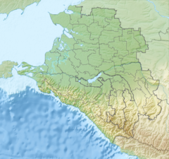
The Kurdzhips (Russian: Курджипс), located in the Caucasus Mountains, is a river in the Apsheronsky District of Krasnodar region, Russia. It is a left tributary of the Belaya near Maykop. It is 100 kilometres (62 mi) long, and has a drainage basin of 768 square kilometres (297 sq mi).[1]

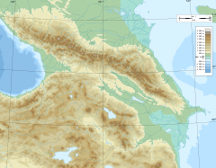
Area around Kurdzhips River
The river is a venue for wilderness and extreme sports.[2][3] The river gained world attention in 2000 when Neanderthal remains were discovered in a cave on its banks.[4][5]
References[]
- ^ Река Курджипс in the State Water Register of Russia (Russian)
- ^ Republic of Adygea Archived 2015-06-02 at the Wayback Machine.
- ^ International Rock Climbing Festival in Guamka, Russia.
- ^ Igor V. Ovchinnikov, Anders Götherström, Galina P. Romanova, Vitaliy M. Kharitonov, Kerstin Lidén & William Goodwin Molecular analysis of Neanderthal DNA from the northern Caucasus. Nature 404, 490-493 (30 March 2000).
- ^ John F. Hoffecker (2002). Desolate Landscapes: Ice-Age Settlement in Eastern Europe. Rutgers University Press.
Categories:
- Tributaries of the Kuban
- Rivers of Krasnodar Krai