Kurrah
Kurrah Dildarnagar
Tajpur Usmanabad | |
|---|---|
village | |
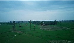
 Lawishely Green farms of Tajpur Kurrah village during Monsoon. | |
| Nickname(s): Coconut village of the North India | |
 Kurrah Dildarnagar Location in Uttar Pradesh, India | |
| Coordinates: 25°23′15″N 83°41′17″E / 25.3876048°N 83.6880159°E | |
| Country | |
| State | Uttar Pradesh |
| District | Ghazipur |
| Established | 1570 |
| Founded by | Zamindar Usman khan |
| Government | |
| • Body | Gram panchayat |
| Area | |
| • Total | 450.34 ha (1,112.81 acres) |
| • Land | 440.025 ha (1,087.325 acres) |
| • Water | 10.315 ha (25.489 acres) |
| Population (2011) | |
| • Total | 7,368 |
| • Density | 1,600/km2 (4,200/sq mi) |
| Languages | |
| • Official | Hindi |
| Time zone | UTC+5:30 (IST) |
Kurrah is a big village in Kamsaar in the Indian state of Uttar Pradesh. Almost 3900 Kamsaar Pathans lived in the village as of 2011.[1][2]
History[]
The Tajpur kurrah village was founded by Zamindar Usman khan a son of Narhar Khan founder of kamsar pathans and founder of Dildarnagar kamsar. Before Usman established this village his father Narhar Khan lived at a place in village name as Kamesardih. According to the old records of village it is said the village would be founded in late 1500 ADs. Later one of Usman's descendants shifted to Bihar and established Akhini village in Bihar state of India. On the banks of Karmanasa river. Tajpur village was The capital of Tajpur estate or Tajpur Zamindari which had 91 villages in year 1901 and had a total area spread of 165 Km².[3]
Agriculture[]
The village is situated at the banks of durgavati and karamnasa river and have good crop producing soil.

The Karamanasa river passes 3.2 kilometer from the village. The total area of the village is 1112 acres out of which the total crop production area of the village is 1000 acres. A variety of crops grow in Purvanchal and Bihar. The village has tractors, harvester and balers. According to 2019 the total number of tractors in village was 45 and the total number of harvesters in the village was 6, and balers were 3. The village have three mosques and two temples. The village also have one play ground. Fish rearing is done on a large scale in the village. There are 20 ponds in village which cover more than 25 acres of land. The village also have one Eidgah. The village is also known as the village of Coconuts because during British era Coconut farming was don in the village on a large scale. More than 5000 trees of Coconuts were planted in the village during 1880s.

Plantation[]
When Zamindar Usman Khan established the village he build a large orchard here which was named Tajpur Bagh. The orchard was spread over an area of 275 bigha and had 8500 trees. Know the orchard build by him have an area of 205 bigha and have more than a thousand trees. Now the orchard is owned by the family of Usman Khan and some in know Jungle.
As of 2011 census, the main population of the village lives in an area of 111 acres with the total number of 976 house holds.[4]
Histrorical Population[]
| Population Growth of Tajpur-Kurrah | |||
|---|---|---|---|
| Census | Population | %± | |
| 1861 | 2,535 | — | |
| 1871 | 2,788 | 10.0% | |
| 1881 | 3,066 | 10.0% | |
| 1891 | 3,374 | 10.0% | |
| 1901 | 3,712 | 10.0% | |
| 1911 | 4,082 | 10.0% | |
| 1921 | 4,490 | 10.0% | |
| 1931 | 4,940 | 10.0% | |
| 1941 | 5,435 | 10.0% | |
| 1951 | 5,434 | 0.0% | |
| 1961 | 5,400 | −0.6% | |
| 1971 | 5,940 | 10.0% | |
| 1981 | 6,534 | 10.0% | |
| 1991 | 7,100 | 8.7% | |
| 2001 | 6,910 | −2.7% | |
| 2011 | 7,316 | 5.9% | |
| Source:Census of India[5][6][7] | |||
Notable people[]
- Khan Shein Kunwar, writer
References[]
- ^ "Bhulekh".
{{cite web}}: CS1 maint: url-status (link) - ^ "2011 census of India".
{{cite web}}: CS1 maint: url-status (link) - ^ Kamsar "Evolution and Spatial organisation of clan settlements in Middle Ganga Valley".
{{cite web}}: Check|url=value (help)CS1 maint: url-status (link) - ^ "Bhulekh".
{{cite web}}: CS1 maint: url-status (link) - ^ "Census of India". mospi.gov.in. Archived from the original on 13 August 2008. Retrieved 23 June 2008.
- ^ "2011 census of India".
- ^ "Historical Census of India". Archived from the original on 17 February 2013. Retrieved 5 November 2015.
- Dildarnagar
- Dildarnagar Fatehpur
- Cities and towns in Ghazipur district
- Towns and villages in Kamsar
- Varanasi division geography stubs
