L'Assomption River

From Wikipedia, the free encyclopedia
L'Assomption River
Rivière L'Assomption
Rivière l'Assomption (Saint-Jean-de-Matha) 2005-08-22.jpg
L'AssomptionRiverMap.png
Location
CountryCanada
ProvinceQuebec
RegionLanaudière
Physical characteristics
SourceL'Assomption Lake
 • locationSaint-Guillaume-Nord
 • coordinates46°27′45″N 74°03′16″W / 46.46250°N 74.05444°W / 46.46250; -74.05444
MouthRivière des Prairies
 • location
Repentigny
 • coordinates
45°42′52″N 73°28′51″W / 45.71444°N 73.48083°W / 45.71444; -73.48083Coordinates: 45°42′52″N 73°28′51″W / 45.71444°N 73.48083°W / 45.71444; -73.48083
Length200 km (120 mi)
Discharge 
 • locationRivière des Prairies

The Assomption River (in French Rivière l'Assomption, named after the Assumption of Mary) is the most important waterway in the Lanaudière region of Quebec, Canada. It is over 200 kilometres (120 mi) long, and has a drainage basin (watershed) of 4,220 square kilometres (1,630 sq mi). Its source is the Mont Tremblant massif. Seven significant rivers flow into the Assomption (de la Boule, Versailles, Noire, la Chaloupe, Ouareau, Saint-Esprit, and Achigan) before it flows into the Rivière des Prairies at Repentigny, Quebec.

About 150,000 people live in the drainage area of this river.

Geography[]

The L'Assomption River watershed overlaps two natural environments, the Laurentian Mountains and the St-Lawrence lowlands, which cover about a third of the watershed area. Its relief is a uniform plain with some hills—from 0 to 100 metres (0 to 328 ft)—dominated by agricultural lands. The texture of the soil is rather fine and rests on an impermeable argillaceous (clay) base.

The Laurentian Mountains form part of the Canadian Shield. They are separated from the lowlands by a well-defined escarpment that rises about 150 metres (490 ft). This escarpment has many waterfalls. The Laurentians Mountains have an average height of 230 metres (750 ft) in the south and 460 metres (1,510 ft) in the north. And there are even mountains of over 600 metres (2,000 ft) in the Mont Tremblant massif where the L'Assomption River forms.

Hydrography[]

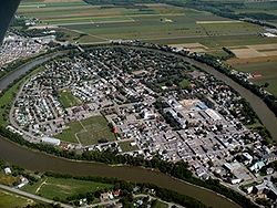
From north to south the average slope of the river decreases. The steeper slopes of the highlands create a fast current whereas the lowland flats produces a slower flow. Moreover, the river meanders a lot which is especially evident at the town of L'Assomption, almost completely surrounded by a large loop of the river.

The L'Assomption River watershed has 490 lakes of which 24 have a surface area larger than 1 square kilometre (250 acres). Most of the lakes are in the Laurentian highlands.

Water quality[]

Urban and industrial pollution[]

The water quality of the L'Assomption River is seriously affected by the area's social-economic conditions. Since 1950, the situation has been complicated by the urbanization of the river banks, by diversified agriculture, and by industrialisation along the southern portion of the river. Although the source of pollution has changed since 1950, because of strict environmental laws and the use of water purification equipment, water pollution is still not fully curbed.

Over 150,000 people live in the river's watershed in 43 municipalities, of which the most important are Repentigny, Joliette, Le Gardeur, and L'Assomption. In addition, the northern portion of the river's watershed is a popular vacation area, swelling the population by about 45,000 people during the vacation season.

The majority of the municipalities take their drinking water from the river and provide it to more than 100,000 people. The drinking water supply to other residences and country cottages, distributed over approximately 90 percent of the watershed area, comes from water wells.

Agricultural pollution[]

Besides the urban and industrial pollution, agricultural pollution also contributes greatly to the environment's contamination.

Agriculture has a dominant position along the river: in 1995 there were 1,305 producers with 60,221 hectares (148,810 acres) under cultivation and possessing 73,563 animals.

Agricultural pollution takes several forms: direct pollution (discharge of manure directly in the rivers) and diffused pollution (infiltration of fertilizer products in the groundwater). Diffused pollution is difficult to control because it has a multitude of sources throughout the whole region. Yet without a solution to this problem the water quality of the river will never have the desired quality.

Drainage basin watercourses[]

Order[1] Label Mouth Coordinates Length (km) Source Coordinates Region
1 L'Assomption River Rivière des Prairies 45°42′52″N 73°28′51″W / 45.71444444°N 73.48083333°W / 45.71444444; -73.48083333 (L'Assomption River) 200 L'Assomption Lake 46°27′45″N 74°03′16″W / 46.4625°N 74.054444°W / 46.4625; -74.054444 (L'Assomption River source) Lanaudière
2  [fr] L'Assomption River 45°50′26″N 73°26′45″W / 45.84055°N 73.44583°W / 45.84055; -73.44583 (L'Achigan River) 83.8  [fr] 45°55′26″N 73°57′03″W / 45.923988°N 73.950733°W / 45.923988; -73.950733 (L'Achigan River source) Lanaudière
3  [fr]  [fr] 45°49′54″N 73°51′31″W / 45.831666666667°N 73.858611111111°W / 45.831666666667; -73.858611111111 (Jourdain River) 19.4 Duquette Lake 45°50′51″N 73°59′11″W / 45.847596°N 73.986294°W / 45.847596; -73.986294 (Jourdain River source) Laurentides
4  [fr]  [fr] 45°51′44″N 73°53′12″W / 45.862222222222°N 73.886666666667°W / 45.862222222222; -73.886666666667 (Abercromby River) 10.8 Connely Lake 45°53′26″N 73°58′00″W / 45.890648°N 73.96662°W / 45.890648; -73.96662 (Abercromby River source) Laurentides
5  [fr]  [fr] 45°53′23″N 73°52′08″W / 45.889722222222°N 73.868888888889°W / 45.889722222222; -73.868888888889 (Beauport River source) 20 Lac de la Crosse 46°00′46″N 73°52′21″W / 46.012824°N 73.872441°W / 46.012824; -73.872441 (Beauport River source) Laurentides
6  [fr]  [fr] 45°51′03″N 73°46′17″W / 45.850833333333°N 73.771388888889°W / 45.850833333333; -73.771388888889 (La Petite Rivière) 13 Saint-Calixte 45°51′03″N 73°46′17″W / 45.850909°N 73.771444°W / 45.850909; -73.771444 (La Petite Rivière source) Laurentides
7  [fr] L'Assomption River 45°51′41″N 73°26′35″W / 45.861388888889°N 73.443055555556°W / 45.861388888889; -73.443055555556 (Saint-Esprit River) 90.4 Huard Lake 46°00′50″N 73°48′44″W / 46.014012°N 73.812306°W / 46.014012; -73.812306 (Saint-Esprit River source) Lanaudière
8  [fr] L'Assomption River 45°54′13″N 73°26′13″W / 45.9035°N 73.437°W / 45.9035; -73.437 (Saint-George Creek) 19.2 Saint-Alexis 45°54′13″N 73°26′13″W / 45.9035°N 73.437°W / 45.9035; -73.437 (Saint-George Creek source) Lanaudière
9 Ouareau River L'Assomption River 45°56′24″N 73°24′27″W / 45.94°N 73.4075°W / 45.94; -73.4075 (Ouareau River) 80  [fr] 46°17′03″N 74°08′35″W / 46.28416°N 74.14306°W / 46.28416; -74.14306 (Ouareau River source) Lanaudière
10  [fr] Ouareau River 46°04′26″N 73°50′47″W / 46.073888888889°N 73.846388888889°W / 46.073888888889; -73.846388888889 (Burton River) 16.9 Racette Lake 46°04′52″N 73°59′58″W / 46.08123°N 73.999314°W / 46.08123; -73.999314 (Burton River source) Lanaudière
Laurentides
11  [fr] Ouareau River 46°06′08″N 73°51′27″W / 46.102222222222°N 73.8575°W / 46.102222222222; -73.8575 (Jean-Venne River) 20.9 Lac des Îles 46°06′45″N 74°01′13″W / 46.112507°N 74.020144°W / 46.112507; -74.020144 (Jean-Venne River source) Lanaudière
12  [fr]  [fr] 46°07′42″N 73°56′17″W / 46.128333333333°N 73.938055555556°W / 46.128333333333; -73.938055555556 (Kenny River) 10.4 Heroux Lake 46°10′02″N 73°59′33″W / 46.167139°N 73.992382°W / 46.167139; -73.992382 (Kenny River source) Lanaudière
13  [fr] Ouareau River 46°12′14″N 73°54′05″W / 46.203888888889°N 73.901388888889°W / 46.203888888889; -73.901388888889 (Beaulne River) 9.2 Beaulne Lake 46°11′37″N 74°00′13″W / 46.193574°N 74.003582°W / 46.193574; -74.003582 (Beaulne River source) Lanaudière
14  [fr] Ouareau River 46°15′55″N 73°59′16″W / 46.265277777778°N 73.987777777778°W / 46.265277777778; -73.987777777778 (Dufresne River) 29.6 Dufresne Lake 46°12′09″N 74°13′13″W / 46.202595°N 74.220213°W / 46.202595; -74.220213 (Dufresne River source) Lanaudière
Laurentides
15  [fr] Ouareau River 45°58′35″N 73°28′34″W / 45.976388888889°N 73.476111111111°W / 45.976388888889; -73.476111111111 (Rouge River) 56.5 Couture Lake 46°10′19″N 73°46′53″W / 46.172008°N 73.781444°W / 46.172008; -73.781444 (Rouge River source) Lanaudière
16  [fr]  [fr] 46°01′43″N 73°37′48″W / 46.028611111111°N 73.63°W / 46.028611111111; -73.63 (Blanche River) 17.8  [fr] 46°08′17″N 73°37′15″W / 46.138178°N 73.620824°W / 46.138178; -73.620824 (Blanche River source) Lanaudière
17  [fr]  [fr] 46°01′05″N 73°32′39″W / 46.018055555556°N 73.544166666667°W / 46.018055555556; -73.544166666667 (Le Grand Ruisseau) 15.1 Sainte-Mélanie 46°08′52″N 73°32′06″W / 46.147722°N 73.534946°W / 46.147722; -73.534946 (Le Grand Ruisseau source) Lanaudière
18  [fr] Ouareau River 46°07′11″N 73°51′00″W / 46.119722222222°N 73.85°W / 46.119722222222; -73.85 (Trudel River) 7.6 Chertsey Lake 46°07′56″N 73°48′52″W / 46.132314°N 73.814338°W / 46.132314; -73.814338 (Trudel River source) Lanaudière
19  [fr] Ouareau River 46°11′46″N 73°53′30″W / 46.196111111111°N 73.891666666667°W / 46.196111111111; -73.891666666667 (Nord River) 6.5 Lac du Pin Rouge 46°14′22″N 73°52′57″W / 46.239342°N 73.882407°W / 46.239342; -73.882407 (Nord River source) Lanaudière
20  [fr] L'Assomption River 46°16′47″N 73°47′26″W / 46.279722222222°N 73.790555555556°W / 46.279722222222; -73.790555555556 (Versailles River) 12.5 spring 46°15′22″N 73°53′56″W / 46.256063°N 73.898856°W / 46.256063; -73.898856 (Versailles River source) Lanaudière
21  [fr] L'Assomption River 46°19′16″N 73°50′31″W / 46.321111111111°N 73.841944444444°W / 46.321111111111; -73.841944444444 (Grande rivière Swaggin) 8.7 Lac des Cèdres 46°18′35″N 73°56′23″W / 46.309754°N 73.939661°W / 46.309754; -73.939661 (Grande rivière Swaggin source) Lanaudière
22  [fr]  [fr] 46°19′07″N 73°51′27″W / 46.318611111111°N 73.8575°W / 46.318611111111; -73.8575 (Petite rivière Swaggin) 12.6 Vauvert Lake 46°22′40″N 73°58′03″W / 46.377806°N 73.967532°W / 46.377806; -73.967532 (Petite rivière Swaggin source) Lanaudière
23  [fr] L'Assomption River 46°22′13″N 73°52′54″W / 46.370277777778°N 73.881666666667°W / 46.370277777778; -73.881666666667 (McGee River) 14.4 Marguerite Lake 46°23′58″N 74°03′24″W / 46.399481°N 74.056659°W / 46.399481; -74.056659 (McGee River source) Lanaudière
24  [fr] L'Assomption River 46°23′02″N 73°53′50″W / 46.383888888889°N 73.897222222222°W / 46.383888888889; -73.897222222222 (Lavigne River) 16.9 St-Amour Lake 46°30′42″N 73°54′53″W / 46.511624°N 73.914802°W / 46.511624; -73.914802 (Lavigne River source) Lanaudière
25  [fr] L'Assomption River 46°16′23″N 73°45′29″W / 46.273055555556°N 73.758055555556°W / 46.273055555556; -73.758055555556 (Rivière de la Boule) 14.7 Laré Lake 46°22′34″N 73°46′51″W / 46.375985°N 73.780914°W / 46.375985; -73.780914 (Rivière de la Boule source) Lanaudière
26  [fr] L'Assomption River 46°12′23″N 73°33′44″W / 46.206388888889°N 73.562222222222°W / 46.206388888889; -73.562222222222 (Noire River) 52.6 Lemieux Lake 46°32′47″N 73°45′12″W / 46.54639°N 73.75333°W / 46.54639; -73.75333 (Noire River source) Lanaudière
27  [fr]  [fr] 46°14′53″N 73°35′02″W / 46.248055555556°N 73.583888888889°W / 46.248055555556; -73.583888888889 (Blanche River) 10.8 Lac à Canards 46°15′15″N 73°40′51″W / 46.254216°N 73.680872°W / 46.254216; -73.680872 (Blanche River source) Lanaudière
28  [fr]  [fr] 46°19′29″N 73°38′18″W / 46.324722222222°N 73.638333333333°W / 46.324722222222; -73.638333333333 (Leprohon River) 16 small lake 46°20′57″N 73°44′09″W / 46.349062°N 73.735735°W / 46.349062; -73.735735 (Leprohon River source) Lanaudière
29  [fr]  [fr] 46°18′51″N 73°29′04″W / 46.314136°N 73.484489°W / 46.314136; -73.484489 (Crique à David) 17 Lac à la Pluie 46°25′12″N 73°38′01″W / 46.420118°N 73.633728°W / 46.420118; -73.633728 (Crique à David source) Lanaudière
30  [fr] L'Assomption River 45°50′12″N 73°24′56″W / 45.836666666667°N 73.415555555556°W / 45.836666666667; -73.415555555556 (Ruisseau du Point du Jour) 20.6 Lanoraie 45°59′14″N 73°18′37″W / 45.987099°N 73.310163°W / 45.987099; -73.310163 (Ruisseau du Point du Jour source) Lanaudière

List of towns crossed[]

The large meander of the L'Assomption River at the Town of L'Assomption

References[]

  1. ^ Ordered by right to left confluence.

External links[]

Map all coordinates using: OpenStreetMap 
Download coordinates as: KML
Retrieved from ""