Lake Tuz
| Lake Tuz | |
|---|---|
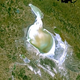 View from space | |
 Lake Tuz | |
| Location | Central Anatolia |
| Coordinates | 38°44′N 33°23′E / 38.733°N 33.383°ECoordinates: 38°44′N 33°23′E / 38.733°N 33.383°E |
| Type | endorheic hypersaline |
| Primary inflows | Peçenek Çayı, Melendiz Çayı |
| Primary outflows | none |
| Catchment area | 11,900 km2 (4,600 sq mi) |
| Basin countries | Turkey |
| Max. length | 80 km (50 mi) |
| Max. width | 50 km (31 mi) |
| Surface area | 1,600 km2 (620 sq mi) |
| Average depth | 0.5 m (2 ft) |
| Max. depth | 1.5 m (5 ft) |
| Surface elevation | 905 m (2,969 ft) |
| Settlements | Şereflikoçhisar |

Lake Tuz (Turkish: Tuz Gölü meaning 'Salt Lake'; anciently Tatta - (Ancient Greek: ἡ Τάττα, Latin: Tatta Lacus)) is the second largest lake in Turkey with its 1,665 km2 (643 sq mi) surface area and one of the largest hypersaline lakes in the world. It is located in the Central Anatolia Region, 105 km (65 mi) northeast of Konya, 150 km (93 mi) south-southeast of Ankara and 57 km (35 mi) northwest of Aksaray.
Geography[]

The lake, occupying a tectonic depression in the central plateau of Turkey, is fed by two major streams, groundwater, and surface water, but has no outlet. Brackish marshes have formed where channels and streams enter the lake. Arable fields surround the lake, except in the south and southwest where extensive seasonally flooded salt-steppe occurs.
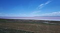
For most of the year, it is very shallow (approx.0.4 m (1 ft)). During winter part of the salt is dissolved in the fresh water that is introduced to the lake by precipitation and surface runoff (to 324‰ salinity). During the summer the lake dries up exposing an average of 30 cm thick salt layer in August. This mechanism is used as a basis for the process of the salt mines in the lake. The three mines operating in the lake produce 63% of the salt consumed in Turkey. The salt mining generates industrial activity in the region, mainly related to salt processing and refining.
Climate[]
The basin of Lake Tuz is influenced by cold semi-arid steppe (Bsk) and Mediterranean (Csa and Csb) climates. Northern areas of the basin such as Kulu are wetter and show a Mediterranean characteristic, meanwhile more southern areas like Çumra, Aksaray and Karapınar have a steppe climate. The area is generally sheltered from moisture-bearing air masses behind the Taurus Mountains. The average yearly precipitation in the basin is 324 mm per m2, thus making the region one of the driest in Turkey.[1][2]
| hideClimate data for Şereflikoçhisar (northeastern shore) | |||||||||||||
|---|---|---|---|---|---|---|---|---|---|---|---|---|---|
| Month | Jan | Feb | Mar | Apr | May | Jun | Jul | Aug | Sep | Oct | Nov | Dec | Year |
| Average high °C (°F) | 3.7 (38.7) |
6.5 (43.7) |
11.4 (52.5) |
16.8 (62.2) |
21.3 (70.3) |
25.8 (78.4) |
29.3 (84.7) |
29.1 (84.4) |
25.5 (77.9) |
12.3 (54.1) |
19.1 (66.4) |
6 (43) |
17.2 (63.0) |
| Daily mean °C (°F) | −0.2 (31.6) |
1.9 (35.4) |
5.8 (42.4) |
10.6 (51.1) |
14.7 (58.5) |
18.6 (65.5) |
21.9 (71.4) |
21.5 (70.7) |
17.9 (64.2) |
12.4 (54.3) |
6.7 (44.1) |
2.1 (35.8) |
11.2 (52.1) |
| Average low °C (°F) | −4.1 (24.6) |
−2.8 (27.0) |
.1 (32.2) |
4.4 (39.9) |
8.1 (46.6) |
11.4 (52.5) |
14.4 (57.9) |
13.9 (57.0) |
10.2 (50.4) |
5.6 (42.1) |
1.1 (34.0) |
−1.8 (28.8) |
5.0 (41.1) |
| Average precipitation mm (inches) | 55 (2.2) |
47 (1.9) |
49 (1.9) |
52 (2.0) |
48 (1.9) |
22 (0.9) |
6 (0.2) |
4 (0.2) |
10 (0.4) |
25 (1.0) |
40 (1.6) |
62 (2.4) |
420 (16.6) |
| Source: [3] | |||||||||||||
History[]

Anciently, the lake was called Tatta, and was located on the frontiers between ancient Lycaonia and Galatia; it had originally belonged to Phrygia, but was afterwards annexed to Lycaonia. The ancients reported that its waters were so impregnated with brine, that any substance dipped into it, was immediately encrusted with a thick coat of salt; even birds flying near the surface had their wings moistened with the saline particles, so as to become incapable of rising into the air, and to be easily caught.[4][5][6] Stephanus of Byzantium speaks of a salt lake in Phrygia, which he calls Attaea (Ἄτταια), near which there was a town called , and which is probably the same as Lake Tatta.[7]
Flora and fauna[]


In 2001, Lake Tuz was declared a specially protected area, including all of the lake surface and surrounding waterbeds and some of the important neighboring steppe areas. The main Turkish breeding colony of greater flamingo (Phoenicopterus roseus) is present on a group of islands in the southern part of the lake. Greater white-fronted goose (Anser albifrons) is the second largest breeder here. Lesser kestrel (Falco naumanni) is a common breeder in surrounding villages.[citation needed]
Gallery[]
Entrance into Lake Tuz

Empty chair at Lake Tuz.
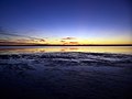
Sunset
Lake Tuz at sunset.

In the dry season, the salt lake is transformed into a salt flat or playa.


See also[]
References[]
- ^ "ALANIN TANIMLANMASI VE ANALİZİ" (PDF). ÇEVRE VE ŞEHİRCİLİK BAKANLIĞI. Archived from the original (PDF) on 22 July 2016. Retrieved 29 October 2016.
- ^ Akin, Burcu (2019). "Tuz Gölü Havzası'nın Kuraklık Analizi". Ulusal Çevre Bilimleri Araştırma Dergisi (in Turkish). Retrieved 2021-07-29.
- ^ "Şereflikoçhisar - Weather History & Climate Data - Meteostat". meteostat.net. Retrieved 2021-06-04.
- ^ Strabo. Geographica. xii. p.568. Page numbers refer to those of Isaac Casaubon's edition.
- ^ Pliny. Naturalis Historia. 31.41, 31.45.
- ^ Dioscorid. 5.126.
- ^ Stephanus of Byzantium. Ethnica. s.v. Βοτίειον.
![]() This article incorporates text from a publication now in the public domain: Smith, William, ed. (1854–1857). "Tatta Lacus". Dictionary of Greek and Roman Geography. London: John Murray.
This article incorporates text from a publication now in the public domain: Smith, William, ed. (1854–1857). "Tatta Lacus". Dictionary of Greek and Roman Geography. London: John Murray.
External links[]
![]() Media related to Lake Tuz at Wikimedia Commons
Media related to Lake Tuz at Wikimedia Commons
| Authority control: National libraries |
|---|
- Lakes of Turkey
- Endorheic lakes of Asia
- Central Anatolia Region
- World Heritage Tentative List for Turkey
- Landforms of Aksaray Province
- Important Bird Areas of Turkey