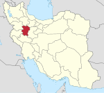
Lalejin
Lalejin
لالجين للین – Lalin | |
|---|---|
City | |
 | |
 Lalejin | |
| Coordinates: 34°58′29″N 48°28′33″E / 34.97472°N 48.47583°ECoordinates: 34°58′29″N 48°28′33″E / 34.97472°N 48.47583°E | |
| Country | |
| Province | Hamadan |
| County | Bahar |
| Bakhsh | Lalejin |
| Elevation | 1,731 m (5,679 ft) |
| Population (2016 Census) | |
| • Total | 14,916 [1] |
| Time zone | UTC+3:30 (IRST) |
| • Summer (DST) | UTC+4:30 (IRDT) |
| Website | http://www.lalejincity.ir |
Lalejin (Persian: لالجين, also Romanized as Lālejīn and Lālajīn; known locally as Lalin (Azeri: لَلين, means Clay), also Romanized as Lalīn; and also known as Shahr-e Lālejīn)[2] is a city and capital of Lalejin District, in Bahar County, Hamadan Province, Iran. At the 2006 census, its population was 14,689, in 3,760 families.[3]
Lalejin is situated 20 kilometres north of Hamadan at an altitude of 1731 meters. It is situated 9 kilometres (5.6 mi) from Bahar, capital of Bahar County.
Lalejin District has an area of 508 square kilometers and a population of 44,568. It is situated in the East of Bahar and is bordered in the west by Hamadan and in north by Kabudrahang and contains Mohajeran and Sofalgaran.
Sister cities[]
| Country | City | |
|---|---|---|
| Italy | Faenza[4] |
References[]
- ^ "Statistical Center of Iran > Home".
- ^ Lalejin can be found at GEOnet Names Server, at this link, by opening the Advanced Search box, entering "-3072808" in the "Unique Feature Id" form, and clicking on "Search Database".
- ^ "Census of the Islamic Republic of Iran, 1385 (2006)" (Excel). Statistical Center of Iran. Archived from the original on 2011-11-11.
- ^ "Iran's Lalejin and Italy's Faenza named sister cities".
External links[]
| Wikivoyage has a travel guide for Lalejin. |
Categories:
- Populated places in Bahar County
- Cities in Hamadan Province
- Bahar County geography stubs

