Lap Corner, Indiana
Lap Corner | |
|---|---|
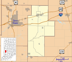
 Lap Corner Location in Clay County | |
| Coordinates: 39°25′51″N 87°04′18″W / 39.43083°N 87.07167°WCoordinates: 39°25′51″N 87°04′18″W / 39.43083°N 87.07167°W | |
| Country | United States |
| State | Indiana |
| County | Clay |
| Township | Sugar Ridge |
| Elevation | 673 ft (205 m) |
| GNIS feature ID | 437627[1] |
Lap Corner is an unincorporated community in northern Sugar Ridge Township, Clay County, Indiana, just north of Center Point. It is part of the Terre Haute Metropolitan Statistical Area.
Geography[]
Lap Corner is located at 39°25′51″N 87°04′18″W / 39.43083°N 87.07167°W.
References[]
- ^ "Lap Corner, Indiana". Geographic Names Information System. United States Geological Survey. Retrieved 2009-10-10.
Categories:
- Unincorporated communities in Clay County, Indiana
- Unincorporated communities in Indiana
- Terre Haute metropolitan area
- Central Indiana geography stubs
