Latorica
| Latorica, Латориця | |
|---|---|
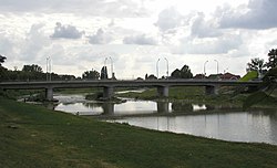 Latorica river near Mukachevo | |
| Location | |
| Country | Ukraine, Slovakia |
| Physical characteristics | |
| Source | Wooded Carpathians |
| • location | Ukraine |
| • coordinates | 48°50′53″N 23°07′47″E / 48.848°N 23.1298°E |
| • elevation | 850 m (2,790 ft) |
| Mouth | |
• location | Bodrog |
• coordinates | 48°27′17″N 21°49′10″E / 48.4547°N 21.8195°ECoordinates: 48°27′17″N 21°49′10″E / 48.4547°N 21.8195°E |
| Length | 188 km (117 mi) |
| Basin size | 7,740 km2 (2,990 sq mi) |
| Discharge | |
| • average | 37 m3/s (1,300 cu ft/s) in Chop |
| Basin features | |
| Progression | Bodrog→ Tisza→ Danube→ Black Sea |
| Tributaries | |
| • right | Laborec |
| Designated | 26 May 1993 |
| Reference no. | 606[1] |

Latorica (Hungarian: Latorca; Slovak: Latorica, pronounced: Latoritsa; Ukrainian: Латориця, translit.: Latorytsia) is a river in the watershed of the Danube. Its source is in the Ukrainian Carpathians (Eastern Carpathian Mountains), near the village . It flows from Ukraine (156.6 km) to Slovakia (31.4 km), 188 km in total and west through the towns Svaliava, Mukacheve, Solomonovo, Chop and Velke Kapusany. Its basin size is 7,740 km2 (2,990 sq mi).[2] Its confluence with the Ondava, in Zemplín, gives rise to the Bodrog river, itself a tributary of the Tisza.
A part of its watershed (Latorica Protected Landscape Area, "Ramsar site No. 606", 44.05 km²) was added to the Ramsar list of wetlands of international importance since 1993.
References[]
- ^ "Latorica". Ramsar Sites Information Service. Retrieved 25 April 2018.
- ^ Plán manažmentu povodňového rizikavčiastkovom povodí Bodrogu, p. 51
External links[]
| Authority control: National libraries |
|---|
This article about a location in Zakarpattia Oblast is a stub. You can help Wikipedia by . |
- Tributaries of the Bodrog
- Rivers of Zakarpattia Oblast
- Rivers of Slovakia
- International rivers of Europe
- Ramsar sites in Slovakia
- Ukraine river stubs
- Zakarpattia Oblast geography stubs
- Europe river stubs
- Slovakia geography stubs