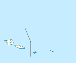
Lepa, Samoa
Lepa | |
|---|---|
Village & Electoral Constituency | |
 Lepa | |
| Coordinates: 14°2′43″S 171°26′27″W / 14.04528°S 171.44083°W | |
| Country | |
| District | Atua |
| Population (2016) | |
| • Total | 166 |
| Time zone | +13 |

Lepa is a small village at the southeastern end of Upolu island in Samoa. The village has a population of 166.[1]
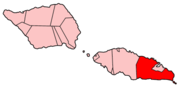
It is also the name of an electoral faipule district, Lepa Electoral Constituency, which consists of six villages, including Lepa village, with a total population of 1538.[1] Lepa should not be confused with the village of Lepea, situated near Apia.
The village and Lepa Electoral Constituency are part of the larger political district of Atua.
Lepa Electoral Constituency[]
The six villages within Lepa Electoral Constituency includes the settlements of A'ufaga, Lealatele and Saleapaga.[1]
Lepa is the birthplace of former Samoan Prime Minister Tuilaepa Aiono Sailele Malielegaoi.[2]
The Lepa area was extensively damaged in the 2009 Samoa earthquake and tsunami. Most of Lepa village was destroyed, leaving just the church and the village's welcome sign standing.[3]
References[]
- ^ Jump up to: a b c "Census 2016 Preliminary count" (PDF). Samoa Bureau of Statistics. Retrieved 2 August 2021.
- ^ "Samoa - Head of Government". Commonwealth Secretariat. Retrieved 12 November 2008.
- ^ McClean, Tamara (2 October 2009). "Searching ruins for reason to live after the tsunami". The Daily Telegraph. Retrieved 5 October 2009.
| show Authority control |
|---|
Coordinates: 14°02′S 171°31′W / 14.033°S 171.517°W
This article about a geographical location in Samoa is a stub. You can help Wikipedia by . |
- Populated places in Atua (district)
- Samoa geography stubs