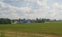
Les Hauteurs, Quebec
Les Hauteurs | |
|---|---|
Municipality | |
 | |
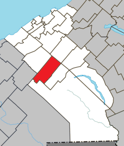 Location within La Mitis RCM | |
 Les Hauteurs Location in eastern Quebec | |
| Coordinates: 48°23′N 68°07′W / 48.383°N 68.117°WCoordinates: 48°23′N 68°07′W / 48.383°N 68.117°W[1] | |
| Country | |
| Province | |
| Region | Bas-Saint-Laurent |
| RCM | La Mitis |
| Constituted | November 7, 1918 |
| Government | |
| • Mayor | Noël Lambert |
| • Federal riding | Haute-Gaspésie—La Mitis—Matane—Matapédia |
| • Prov. riding | Matane-Matapédia |
| Area | |
| • Total | 104.40 km2 (40.31 sq mi) |
| • Land | 102.28 km2 (39.49 sq mi) |
| Population | |
| • Total | 524 |
| • Density | 5.1/km2 (13/sq mi) |
| • Pop 2006-2011 | |
| • Dwellings | 249 |
| Time zone | UTC−5 (EST) |
| • Summer (DST) | UTC−4 (EDT) |
| Postal code(s) | G0K 1C0 |
| Area code(s) | 418 and 581 |
| Highways | |
| Website | municipalite. leshauteurs.qc.ca |

Les Hauteurs is a municipality in Quebec, Canada.
See also[]
References[]
- ^ Reference number 283934 of the Commission de toponymie du Québec (in French)
- ^ Jump up to: a b Geographic code 09015 in the official Répertoire des municipalités (in French)
- ^ Jump up to: a b "(Code 2409015) Census Profile". 2011 census. Statistics Canada. 2012.
External links[]
 Media related to Les Hauteurs at Wikimedia Commons
| show Adjacent Municipal Subdivisions |
|---|
| hide | |
|---|---|
| Cities & Towns | |
| Municipalities | |
| Parishes |
|
| Villages | |
| Unorganized territories | |
| |
| show Authority control |
|---|
This Quebec location article is a stub. You can help Wikipedia by . |
Categories:
- Municipalities in Quebec
- Incorporated places in Bas-Saint-Laurent
- Quebec geography stubs