| show Ancient, medieval, and historical Armenian churches and monasteries |
|---|
| Armenia |
- Aragatsotn
- Ararat
- Armavir
- Doghs
- Targmanchats Vank
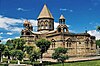
- Vagharshapat (Etchmiadzin, St. Gayane, St. Hripsime, St. Mary, Shoghakat)
- Zvartnots
- Gegharkunik
- Kotayk
- Lori
- Shirak
- Syunik
- Tavush
- Vayots Dzor
- Yerevan
- Avan (St. John, St. Mary, Tsiranavor)
- Kanaker (St. James, St. Mary)
- Yerevan (Gethsemane, Katoghike, St. Anania, St. George, St. Gregory, St. John, St. Mary, St. Paul and Peter, Zoravor)
| |
|---|
| Artsakh | |
|---|
| Azerbaijan (List) |
- Ablah
- Agarak
- Agulis (St. John, St. Kristapor, Kumsi, St. Mary, St. Minas, , St. Thomas, Vank)
- Amuravan
- Amutegh
- Anahit
- Anushavan
- Aparan
- Aprakunis
- Arakhish
- Aresh
- Armavashen
- Ayrivank
- Baku (St. Gregory, St. Mary, St. Thaddeus)
- Banants (St. Gregory, St. Mary, Targmanchats, Dzernavor)
- Bayan
- Bazarkend
- Berdak
- Bist (St. Mary, Holy Sign)
- Brajur
- Chahuk (St. John, Shoghakat)
- Chalet
- Chaldash
- Chanakhchi
- Chaparli
- Charek Vank
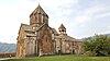
- Dadivank
- Dasno Vank
- Dastak
- Dastapor
- Demirov
- Diza
- Dsaghkots Anapat
- Frank
- Gabriel
- Gag
- Ganja (St. George, St. Gregory, St. John, St. Sarkis, Kristos, St. Mary, St. Thaddeus)
- Gardman
- Gavurkala
- Getabek (St. Mary, Church)
- Getashen
- Gharadaghlu
- Ghazakh
- Goghtn
- Gtichavank
- Hajishen
- Hakobshen (St. Gregory, St. Minas)
- Handaberd
- Harants
- Harants Vank
- Hazarabyurats Vank
- Hazaraprkich Vank
- Horekavank
- Husakan
- Jrdakhan
- Jugha (Holy Savour, Hovi, St. Mary)
- Kabakhtapa
- Kaghni
- Karasakal
- Karhani Vank
- Karmir Vank
- Katarovank
- Kavakavank
- Keratavank
- Khoshkashen (St. Mary, St. Yeghishe)
- Khoylu
- Khunasavank
- Kish
- Kona
- Kovakheghdi Vank
- Krmanka Vank
- Krzen
- Kuki (St. George, St. Mary, St. Vardan)
- Kusanats Anapat
- Kyolk
- Lianosi Vank
- Masants Vank
- Mesropavan
- Minkend
- Mruti Anapat
- Nakhichevan (St. George, Trinity)
- Navish
- Nerkin Aza
- Norakert
- Norashen (St. George, St. Hripsime, St. John, St. Mary, St. Stephen)
- Nors
- Nukzar
- Odsop
- Okht
- Okhti Drni
- Ordubad
- Ovasap
- Pahest
- Pand
- Paraka (Holy Cross, St. Elia, St. Simeon, St. Stephen)
- Partav
- Pip (Barsam, St. Pepronia, St. Stephen)
- Poladlu
- Ptkataghi Vank
- Ramis (St. John, St. Mary, St. Sarkis)
- Shahpekar
- Shahponk (St. Gregory, St. Sarkis)
- Shalva
- Shamen
- Shamkhor
- Shavarshavan
- Shrju
- Shusha (Ghazanchetsots, Kanach Zham, Kusanats Vank, St. Mary)
- Taghaser Anapat
- Tambat
- Targmanchats
- Tatlu
- Tazekend
- Tkhkuti
- Togh (St. John, St. Stephen, Red Church)
- Tran Yeghtsi
- Tsar
- Tsghna
- Tsitsernavank
- Vankasar
- Vardashen (Church, St. Yeghishe)
- Varzakan
- Verin Karhat
- Voghohi (Holy Cross, St. Stephen)
- Voskanapat
- Yeghishe Arakyal
- Yeghnasari Vank
- Yekeghetsadzor
- Yeni Zod
- Yerenjak
- Yeri Vank
- Yerits Mankants
- Yermoghia
- Zakatala
|
|---|
| Georgia (List) |
- Abibos
- Abisosi Vank
- Akhaltskha
- Bnidzor
- Dsughrughashen
- Pokr Khanchali
- Shahumyan (St. Mary, Holy Sunday)
- Tbilisi (Vank, Bethlehem, Chugureti, Ejmiatsnetsots, St. George, St. Gregory, Jigrasheni Avetyats, Kamoyants, Karapet, Karapi, Karmir Avetaran, Khojivank, Geghardavank, Mughni, Norashen, Holy Cross, Holy Sign, St. Sarkis, St. Stephen, Dzorabash, Tandoyants, Zrkinyants)
- Tokavank
- Tskhinvali
|
|---|
| Turkey (List) |
- Abdelmseh
- Ablbuhar
- Abrahamavank
- Adamakert
- Adana (St. Mary, Morotu)
- Agarak
- Aghberts Vank
- Aghbunar
- Aghmaghara
- Aghperig
- Aghtamar
- Agreki Vank
- Ahavank
- Akevra
- Akhkosi Vank
- Akner
- Aknji Vank
- Akori
- Albayrak
- Amrdolu
- Anarzaba
- Ani (List, Cathedral, Holy Saviour, Gaskashen, Honents, Abugamerats, Arakelots, Kusanats, Abukhanmi, Aghjkaberd, Hovi)
- Aparank
- Arakelots Vank
- Arapgir
- Argelan
- Arkakaghni
- Arkayakaghni Vank
- Arter
- Ashtishat
- Aygek
- Ayridzor
- Baberd (St. Ohan, Kristos)
- Bagavan
- Bagnayri Vank
- Bana
- Bardzraberd
- Barsam
- Barthoghimevos Vank
- Berkri
- Çanakkale
- Charkhapan
- Chordvank
- Constantinople (Galata, Kuzguncuk, Fatih, Kartal, Samatya, Taksim, Beyoğlu, Beyoğlu)
- Drazark
- Dzor
- Elazig
- Enda Vank
- Endzakar
- Eskişehir
- Fenki Vank
- Firsi Vank
- Frnuz
- Garapazar
- Gaziantep
- Gelati Vank
- Ghukas
- Goms
- Grneri Vank
- Hekimkhan
- Hogots
- Hogyats Vank
- Horomos
- Ishkhan
- Ishkhanigom
- İskenderun
- Jermik
- Kamari Vank
- Kamatun
- Kamrjadzor
- Kangvar
- Kanzak
- Kaposi Vank
- Karapet Vank
- Karasni Vank
- Karmirvank
- Karmravank
- Kars (Cathedral, St. Mary)
- Kava
- Kes
- Kesaria
- Khachatro Anapat
- Khachbazari
- Khalfeti
- Khora Anapat
- Khorsana
- Khtzkonk
- Ktuts
- Khunarktor
- Levonberd
- Lim
- Malatia
- Mam
- Manazkert
- Manravank
- Marinos Vank
- Mazhak
- Medzopavank
- Mokats Vank
- Mokhraberd
- Molevoni Vank
- Mordsako
- Mren
- Mush (St. Marine, Holy Sign)
- Narekavank
- Odeli
- Odzi Khazina
- Ogsend
- Ohan
- Oski Tur
- Otur
- Pakagetik
- Rshtuni
- Sachle
- Sbkhech
- Sis (Andul Vank, Gavikata Vank, Atanagine Vank)
- Sivrihisar
- Skanchelagordz Vank
- Smbataberd
- Smyrna
- Soradir
- Sparanits
- Srkuvank
- Tarsiakh
- Tashan
- Tavblur
- Tekor
- Tevrik
- Tigranakert
- Trebizond
- Tsarakar Vank
- Tspni
- Van
- Varagavank
- Vardan Vank
- Vardenotsats
- Vardkan Anapat
- Varzahan
- Vosteghavank
- Yeghegnamor
- Yeghrdut
- Yerazgavors
- Zoravank
|
|---|
| Iran (List) |
- Thadei Vank
- Maghardavank
- Dzordzori Vank
- Hovi
- Darashamb
- Haftvan
- Khoy
- Mahlezan
- Tabriz (St. Mary, St. Sarkis, Mariam)
- Mujumbar
- Sohrol
- Maragheh
- Sarnaq
- Nor Jugha (Vank, St. Mary, St. George, St. Stephen, St. John, St. Catherine, Bethlehem, St. Nicholas, St. Gregory, St. Sarkis, St. Minas, St. Nerses)
- Shiraz
- Tehran (St. Thaddeus, St. George)
|
|---|
| Jerusalem (Palestine/Israel) |
- Armenian Quarter
- Cathedral of St. James
- Church of St. Toros
- Church of the Holy Archangels
- Chapel of St. Helena
|
|---|
| Asia |
- Syria
- India
- Chennai
- Calcutta
- Chinsura
- Saidabad
- Bangladesh
- Israel
- Cyprus
- Magar Vank
- Notre Dame de Tyre
- Ganchvor
|
|---|
| Europe |
- Crimea
- Ukraine
- Russia
- Romania
- Italy
|
|---|