List of Caribbean islands

This is a list of Caribbean islands. Almost all of these islands are in the Caribbean Sea with only a few in inland lakes. The largest island is the island of Cuba. Some of the smaller islands are referred to as a rock or reef. Islands are listed in alphabetical order by country of ownership and/or those with full independence and autonomy. Islands with coordinates can be seen on a map with the link to the right.
Antigua and Barbuda[]

There are 54 islands in Antigua and Barbuda. There are three main islands, the two populated islands (Antigua and Barbuda) and Redonda. There are 51 off-shore islands. The islands of the country of Antigua and Barbuda include:[1][2][3]
- Antigua, 17°5′0″N 61°48′0″W / 17.08333°N 61.80000°W, 280 km2 (110 sq mi)
- [4]
- Prickly Pear Island17°10′33″N 61°47′53″W / 17.17583°N 61.79806°W
- Great Bird Island17°8′46″N 61°43′31″W / 17.14611°N 61.72528°W
- 17°08′35.5″N 61°43′37.5″W / 17.143194°N 61.727083°W
- 17°08′11″N 61°43′23″W / 17.13639°N 61.72306°W
- 17°8′10″N 61°43′52″W / 17.13611°N 61.73111°W
- 17°8′1″N 61°43′47″W / 17.13361°N 61.72972°W
- Long Island17°9′19″N 61°45′14″W / 17.15528°N 61.75389°W
- 17°8′44″N 61°45′48″W / 17.14556°N 61.76333°W
- 17°7′44″N 61°46′11″W / 17.12889°N 61.76972°W
- 17°09′27″N 61°44′17″W / 17.15750°N 61.73806°W
- Hell's Gate Island17°8′26″N 61°43′18″W / 17.14056°N 61.72167°W
- 17°8′16″N 61°43′41″W / 17.13778°N 61.72806°W
- Guiana Island17°7′26″N 61°43′57″W / 17.12389°N 61.73250°W
- Crump Island17°6′32″N 61°43′8″W / 17.10889°N 61.71889°W
- (Henry Island)17°04′05″N 61°41′26″W / 17.06806°N 61.69056°W
- 17°5′57″N 61°43′24″W / 17.09917°N 61.72333°W
- 17°4′45″N 61°40′20″W / 17.07917°N 61.67222°W
- 17°6′46″N 61°43′40″W / 17.11278°N 61.72778°W
- Green Island17°4′11″N 61°39′58″W / 17.06972°N 61.66611°W
- Pelican Island17°06′21″N 61°42′17″W / 17.10583°N 61.70472°W
- York Island17°3′11″N 61°40′9″W / 17.05306°N 61.66917°W
- Codrington Island17°6′9″N 61°42′21″W / 17.10250°N 61.70583°W
- 17°0′52″N 61°46′58″W / 17.01444°N 61.78278°W
- 17°7′21″N 61°47′9″W / 17.12250°N 61.78583°W
- Five Islands17°04′50″N 61°54′50″W / 17.08056°N 61.91389°W
- 17°6′43″N 61°54′8″W / 17.11194°N 61.90222°W
- 17°01′31″N 61°53′28″W / 17.02528°N 61.89111°W
- 17°5′44″N 61°53′14″W / 17.09556°N 61.88722°W
- 17°09′49″N 61°45′27.0″W / 17.16361°N 61.757500°W
- 17°07′42.0″N 61°46′13″W / 17.128333°N 61.77028°W
- 17°03′40″N 61°40′29″W / 17.06111°N 61.67472°W
- 17°8′4″N 61°55′36″W / 17.13444°N 61.92667°W
- 17°2′27″N 61°40′48″W / 17.04083°N 61.68000°W
- 17°9′39″N 61°52′6″W / 17.16083°N 61.86833°W
- 17°6′51″N 61°46′8″W / 17.11417°N 61.76889°W
- 17°02′53.5″N 61°40′19.5″W / 17.048194°N 61.672083°W
- Barbuda, 17°37′0″N 61°48′0″W / 17.61667°N 61.80000°W, 161 km2 (62 sq mi)
- Redonda (uninhabitated), 16°56′20″N 62°20′30″W / 16.93889°N 62.34167°W, 1.3 km2 (0.50 sq mi)

The Bahamas[]
The Commonwealth of the Bahamas is located in the Lucayan Archipelago, the portion of the Caribbean region in the North Atlantic Ocean rather than in or bordering the Caribbean Sea. There are 700 islands and 2,400 cays in The Bahamas. There are 30 inhabitated islands. Andros Island is the largest island in the Bahamas. Large island groups include Berry Islands and Exuma. The following islands are some of the more notable islands (cays) (see the main article for a comprehensive listing of all islands):[5][6]
- Abaco Island, 26°27′54″N 77°08′04″W / 26.46504°N 77.13432°W
- Abner Cay, 25°40′24″N 77°46′31″W / 25.67331°N 77.77518°W
- Acklins, 22°28′49″N 73°53′42″W / 22.48023°N 73.89496°W
- Adderley Cay (part of Exuma), 23°47′16″N 76°06′49″W / 23.7878°N 76.11349°W
- Alder Cay, 25°32′12″N 77°42′50″W / 25.53659°N 77.71398°W
- Ambergris Cay (Berrey Islands), 25°40′10″N 77°50′10″W / 25.66946°N 77.83599°W
- Andros Island, 24°26′00″N 77°57′00″W / 24.43333°N 77.95°W
- Anna Cay, 26°32′59″N 76°57′39″W / 26.54985°N 76.96085°W
- Arawak Cay (Fish Fry), 25°05′00″N 77°22′00″W / 25.08333°N 77.36667°W
- Archers Cay, 26°36′01″N 77°09′59″W / 26.60023°N 77.1664°W
- Athol Island, 25°05′00″N 77°16′00″W / 25.08333°N 77.26667°W
- Atwood Cay (Samana Cay), 23°04′54″N 73°44′19″W / 23.08178°N 73.73866°W
- Barataria Island (part of Exuma), 23°41′17″N 76°03′13″W / 23.68808°N 76.05358°W
- Serranilla Bank (Beacon Cay), 24°52′35″N 76°50′26″W / 24.87645°N 76.84043°W
- Bell Island, 24°18′11″N 76°33′28″W / 24.30299°N 76.55774°W
- Berry Islands District, 25°43′16″N 77°49′53″W / 25.72111°N 77.83139°W
- Big Major Cay (Pig Beach)
- Bimini Islands, 25°44′36″N 79°14′58″W / 25.74331°N 79.24936°W
- Bird Cay (part of Berry Islands), 25°23′59″N 77°48′56″W / 25.39985°N 77.81553°W
- Bitter Guana Cay (part of Exuma), 24°08′04″N 76°24′52″W / 24.13436°N 76.41445°W
- Bock Cat Cay (part of Exuma), 23°44′36″N 76°12′15″W / 23.74345°N 76.20414°W
- Bonds Cay (part of Berry islands), 25°29′26″N 77°43′18″W / 25.49056°N 77.72156°W
- Booby Cay, 22°19′29″N 72°43′11″W / 22.32467°N 72.71986°W
- Bowe Cay (part of Exuma), 23°26′58″N 75°57′56″W / 23.4494°N 75.96554°W
- Cabbage Cay (part of Berry Islands), 25°34′00″N 77°43′00″W / 25.56667°N 77.71667°W
- Castaway Cay (private island and an exclusive port for Disney Cruise Line), 26°05′27″N 77°31′54″W / 26.09071°N 77.5316°W
- Cat Island, 24°19′51″N 75°26′11″W / 24.33083°N 75.43625°W
- Cat Cays (part of Bimini), 25°32′00″N 79°17′00″W / 25.53333°N 79.28333°W
- Cay Sal Bank, 23°49′24″N 80°03′35″W / 23.82335°N 80.0596°W
- Children's Bay Cay (part of Exuma, aka Williams Cay), 23°45′12″N 76°04′42″W / 23.75337°N 76.0783°W
- Chub Cay, 25°24′45″N 77°54′10″W / 25.41254°N 77.90264°W
- Cistern Cay (part of Berry Islands), 25°46′25″N 77°53′09″W / 25.77361°N 77.88573°W
- Coakley Cay, 23°26′30″N 76°00′34″W / 23.44162°N 76.00936°W
- Cockroach Cay, 25°27′39″N 77°47′36″W / 25.46075°N 77.79333°W
- Comfort Cay (part of Berry Islands), 25°34′42″N 77°43′49″W / 25.57821°N 77.7303°W
- Compass Cay, 24°16′01″N 76°31′01″W / 24.26693°N 76.51693°W
- Conception Island, 23°50′06″N 75°06′57″W / 23.83512°N 75.11593°W
- Cormorant Cay (part of Berry Islands), 25°29′56″N 77°48′51″W / 25.49883°N 77.8141°W
- Crooked Island, 22°42′58″N 74°10′25″W / 22.71615°N 74.17364°W
- Culmer's Cay (part of Exuma), 23°27′42″N 75°55′17″W / 23.46154°N 75.92131°W
- Cupids Cay (Governor's Island), 25°11′30″N 76°15′00″W / 25.19167°N 76.25°W
- Current Island, 25°21′30″N 76°49′14″W / 25.3582°N 76.82058°W
- Devils Cay (part of Berry Islands), 25°36′07″N 77°43′42″W / 25.60186°N 77.72821°W
- Diamond Rock (part of Berry Islands), 25°23′48″N 77°52′36″W / 25.39674°N 77.87658°W
- Discovery Island
- Dolly Cay, 23°38′49″N 77°21′55″W / 23.64686°N 77.36535°W
- Dove Cay, 23°33′26″N 75°19′44″W / 23.5573°N 75.32899°W
- Egg Island, 25°29′00″N 76°53′00″W / 25.48333°N 76.88333°W
- Elbow Cay, 26°31′40″N 76°58′05″W / 26.5278°N 76.96807°W
- Elbow Cays (Cay Sal Bank), 23°57′12″N 80°26′42″W / 23.95343°N 80.44506°W
- Eleuthera Island
- Elizabeth Island, 23°30′29″N 75°43′35″W / 23.50796°N 75.72627°W
- Exuma Island
- Fortune Island (Long Cay), 22°36′09″N 74°19′54″W / 22.60244°N 74.33161°W
- Frazer Hog Cay, 23°23′37″N 75°28′50″W / 23.39353°N 75.48045°W
- Galliot Cay, 23°38′27″N 75°19′48″W / 23.64071°N 75.32994°W
- Goat Cay
- Gorda Cay (Castaway Cay), 26°05′27″N 77°31′54″W / 26.09071°N 77.5316°W
- Grand Bahama, 26°38′00″N 78°25′00″W / 26.63333°N 78.41667°W
- Great Exuma Island, 23°34′29″N 75°53′23″W / 23.57476°N 75.88966°W
- Great Guana Cay, 26°40′37″N 77°07′36″W / 26.6769°N 77.12672°W
- Great Harbour Cay, 25°43′43″N 77°50′25″W / 25.7287°N 77.84028°W
- Great Inagua Island, 21°03′27″N 73°19′32″W / 21.05741°N 73.32545°W
- Great Isaac Cay (Rock), 26°01′45″N 79°05′13″W / 26.02906°N 79.08697°W
- Great Stirrup Cay
- Green Turtle Cay
- Halls Pond Cay
- Harbour Island
- Highbourne Cay
- Hoffman Cay
- Inagua Island
- Iron Cay
- Jewfish Cay
- Joulter Cays
- Lee Stocking Island
- Little Abaco Island
- Little Cistern Cay
- Little Darby Island
- Little Farmer's Cay
- Little Harbour Cay
- Little Inagua, 21°30′N 73°00′W / 21.5°N 73°W
- Little Petit Cay
- Little San Salvador Island (Half Moon Cay)
- Little Stirrup Cay
- Little Wax Cay
- Little Whale Cay
- Long Cay
- Long Island, 23°13′46″N 75°06′41″W / 23.22936°N 75.11129°W
- Lyford Cay
- Madam Dau's Cay
- Major's Island
- Man Island
- Man-O-War Cay
- Mangrove Cay
- Mayaguana
- Middle Cay
- Moore's Island
- Moriah Harbour Cay
- Musha Cay
- New Providence, 25°01′50″N 77°24′16″W / 25.03042°N 77.40431°W
- Norman's Cay
- North Andros
- North Bimini
- North Cat Cay
- North Elbow Cay
- O'Brien Cay
- Ocean Cay
- Over Yonder Cay
- Paradise Island
- Perpall's Cay
- Prime Cay
- Ragged Island
- Rose Island
- Royal Island
- Rum Cay
- Russell Island
- Salt Cay
- Samana Cay
- Sampson Cay
- San Salvador Island, 24°02′45″N 74°29′29″W / 24.04584°N 74.49142°W
- Sandy Cay
- Schooner Cays
- Scotland Cay
- Seal Cay
- South Bimini
- South Cat Cay
- South Stirrup Cay
- Staniel Cay
- Stocking Island
- Stranger Cay
- Sugar Loaf Cay
- Sweeting Cay
- Vigilant Cay
- Waderick Wells Cay
- Walker's Cay
- Watling Island
- Wax Cay
- Windermere Island
- Wood Cay
Barbados[]
There are currently two islands and two banks in Barbados. An additional historical island that no longer exists as an island is also included in this list.[7]
- Barbados, 13°09′52″N 59°33′06″W / 13.16453°N 59.55165°W
- Culpepper Island (uninhabited), 13°09′57″N 59°26′36″W / 13.16583°N 59.44343°W
- Pelican Island (Historical, uninhabited), 13°06′02″N 59°37′43″W / 13.10066°N 59.62849°W
- Trader Bank, 13°03′N 59°39′W / 13.05°N 59.65°W
- The Shadows (Bank), 12°58′00″N 59°28′00″W / 12.96667°N 59.46667°W
Belize[]
There are about 180 islands in Belize. Some of the larger islands of Belize in the Caribbean Sea include:[8]
- Turneffe Atoll (Turneffe Islands), 116 km2 (45 sq mi), 17°20′00″N 87°52′00″W / 17.33333°N 87.86667°W
- Ambergris Group, 76.8 km2 (29.7 sq mi), 18°02′51″N 87°55′22″W / 18.04762°N 87.9229°W
- Douglas Cay, 65 km2 (25 sq mi), 17°20′00″N 87°55′00″W / 17.33333°N 87.91667°W
- Drowned Cays, 20.2 km2 (7.8 sq mi), 17°28′05″N 88°04′48″W / 17.46792°N 88.07997°W
- Hick's Cayes, 10.5 km2 (4.1 sq mi), 17°39′34″N 88°09′31″W / 17.6594°N 88.15859°W
- Lighthouse Reef, 17°18′N 87°33′W / 17.300°N 87.550°W
Colombia[]
Several Departments of Colombia include islands in the Caribbean area.[9]
Bolívar Department[]

Islands of the Bolívar Department of Columbia includle:[9]
- Rosario Islands (Islas del Rosario), 10°10′00″N 75°46′00″W / 10.16667°N 75.76667°W
- Isla Grande, 10°10′55″N 75°44′06″W / 10.18194°N 75.735°W
- Isla Marina, 10°10′28″N 75°45′14″W / 10.17435°N 75.75401°W
- Isla de Roberto, 10°11′00″N 75°46′00″W / 10.18333°N 75.76667°W
- Isla Rosario, 10°11′53″N 75°45′26″W / 10.19811°N 75.75725°W
- Isla del Tesoro, 10°14′06″N 75°44′19″W / 10.23487°N 75.73861°W
- Isla del Pirata, 10°24′03″N 75°33′17″W / 10.400784624618357°N 75.55460246471826°W
- Isla Pelicano, 10°11′05″N 75°43′40″W / 10.184779192716787°N 75.72776381155103°W[10]
- Isla Rosa, 10°10′50″N 75°46′33″W / 10.180567355171263°N 75.77575093217862°W[10]
- Isla Gigi, 10°24′03″N 75°33′17″W / 10.400784624618357°N 75.55460246471826°W
- Fuerte Island, 9°23′13″N 76°10′52″W / 9.38706°N 76.18113°W
- Tierra Bomba Island (Isla Tierra Bomba), 10°21′22″N 75°34′20″W / 10.35621°N 75.57234°W
- Isla Barú, 10°12′58″N 75°36′01″W / 10.21616°N 75.60023°W
- Isla de la Manga, 10°24′44″N 75°32′08″W / 10.412346213566934°N 75.53549051021686°W
- Isla Diablo, 10°23′52″N 75°31′37″W / 10.3978°N 75.52694°W
- Isla de Manzanillo, 10°23′00″N 75°32′00″W / 10.38333°N 75.53333°W
- Isla Maparadita, 10°22′00″N 75°30′47″W / 10.36667°N 75.51306°W
- Isla Cocosolo, 10°21′01″N 75°30′50″W / 10.35015°N 75.51385°W
- Isla Brujas, 10°19′59″N 75°30′49″W / 10.33293°N 75.51353°W
- Isla Abanico, 10°18′26″N 75°34′44″W / 10.30718°N 75.57899°W
Córdoba Department[]
Islands in the Córdoba Department include:[9]
Magdalena Department[]
Islands in the Magdalena Department include:[9]
- Isla de Salamanca, 10°58′00″N 74°30′00″W / 10.96667°N 74.5°W
- Isla El Morro, 11°14′59″N 74°13′48″W / 11.24964°N 74.22991°W
- Isla de La Aguja, 11°19′10″N 74°11′48″W / 11.31956°N 74.19666°W]
- Isla Bóqueron Grande, 10°57′34″N 74°17′52″W / 10.9594°N 74.29781°W
San Andrés, Providencia and Santa Catalina[]
Islands in the Archipelago of San Andrés, Providencia and Santa Catalina include:[9]
- Acuario Cay (Cayo Rosa), 12°33′00″N 81°41′00″W / 12.55°N 81.68333°W
- Alice Shoal (submerged reef), 16°05′N 79°22′W / 16.083°N 79.367°W
- Bajo Nuevo Bank, 15°53′N 78°38′W / 15.883°N 78.633°W
- Bayley Islet (Cayo Bayley), 13°21′N 81°21′W / 13.35°N 81.35°W
- Basalt Islet
- Brothers Cay (Cayos Hermanos), 13°21′N 81°21′W / 13.35°N 81.35°W
- Crab Cay (Cayo Congrejo), 13°22′00″N 81°21′00″W / 13.36667°N 81.35°W
- Cayos de Albuquerque, 12°10′01″N 81°51′31″W / 12.16706°N 81.85857°W
- North Cay
- South Cay
- Córdoba Cay (also known as Haynes Cay), 12°33′05″N 81°41′17″W / 12.55133°N 81.68807°W
- Easy Cay
- Grunt Cay
- Cayos de Este Sudeste, 12°25′14″N 81°28′37″W / 12.42047°N 81.47706°W
- Bolívar Cay (also known as Courtown or West Cay)
- East Cay
- Palm Cay
- Isla de Providencia, 13°21′10″N 81°22′27″W / 13.35291°N 81.37424°W
- Quita Sueño Bank, 14°19′N 81°10′W / 14.317°N 81.167°W
- Rocky Cay, 12°32′30″N 81°42′07″W / 12.54155363677761°N 81.70184746222002°W
- Roncador Bank, 13°34′N 80°04′W / 13.567°N 80.067°W
- Roncador Cay, 13°32′N 80°03′W / 13.533°N 80.050°W
- San Andrés Island, 12°35′N 81°42′W / 12.583°N 81.700°W
- Santa Catalina Island, 13°23′18″N 81°22′25″W / 13.38833°N 81.37361°W
- Santander Cay (also known as Cotton Cay)
- Serrana Bank, 14°20′N 80°20′W / 14.333°N 80.333°W
- Serranilla Bank, 15°50′N 79°50′W / 15.833°N 79.833°W
- Sucre Islet (also known as Johnny Cay)
Sucre Department[]
Islands in the Sucre Department include the following islands in the Archipelago of San Bernardo:[9]

- Bóqueron Island
- Cabruna Island (Isla Cabruna), 9°44′32″N 75°41′05″W / 9.74216°N 75.6848°W
- Ceycén Island (Isla Ceycen), 9°41′39″N 75°51′16″W / 9.69412°N 75.85441°W
- Mangle Island, 9°45′50″N 75°47′18″W / 9.7638°N 75.7882°W
- Maravilla Island (Isla Maravilla), 9°44′58″N 75°52′48″W / 9.74938°N 75.88002°W
- Múcura Island (Isla Múcura ), 9°46′52″N 75°52′20″W / 9.78113°N 75.8723°W
- Palma Island (Isla Palma), 9°44′38″N 75°49′02″W / 9.74393°N 75.81722°W
- Panda Island, 9°44′40″N 75°49′07″W / 9.7444°N 75.8187°W
- Salamanquilla Island, 9°44′10″N 75°44′54″W / 9.73600791354626°N 75.74831314548521°W[10]
- San Barnardo Island, 9°41′40″N 75°42′12″W / 9.694456840225165°N 75.70341918411783°W
- Santa Cruz del Islote, 9°47′09″N 75°51′33″W / 9.78593°N 75.8591°W
- Tintipán Island, 9°47′38″N 75°50′35″W / 9.79379°N 75.84297°W
Costa Rica[]

There are about 79 islands in Costa Rica.[11] The largest islands in the Caribbean Sea are listed below:
- Isla Calero, 151.6 km2 (58.5 sq mi), 10°50′58″N 83°37′23″W / 10.8495°N 83.6231°W
- Isla Brava, 44.4 km2 (17.1 sq mi)
- Isla Uvita, 0.8 km2 (0.31 sq mi), 9°59′36″N 83°00′40″W / 9.99342°N 83.01113°W
Cuba[]

Cuba consists of over 4,000 islands and cays surrounding the country's main island, many of which make up archipelagos. Off the south coast are two main archipelagos, Jardines de la Reina and the Canarreos Archipelago. The Sabana-Camagüey Archipelago runs along the northern coast and contains roughly 2,517 cays and islands.[12] The Colorados Archipelago is located off the north-western coast. The following islands are some of the major islands in the island country Cuba:[13]
- Cuba (largest island in the Caribbean 104,556 km2 (40,369 sq mi), 21°56′02″N 78°45′15″W / 21.93384°N 78.75425°W
- Canarreos Archipelago, 21°38′22″N 82°14′10″W / 21.6394444°N 82.2361111°W
- Isla de la Juventud (2nd largest island in Cuba at 2,200 km2 (850 sq mi)), 21°45′N 82°51′W / 21.750°N 82.850°W
- Ernst Thälmann Island (formerly Cayo Blancos del Sur, aka Cayo Ernesto Thaelmann), 22°02′00″N 81°24′00″W / 22.033333°N 81.4°W
- Cayo Largo del Sur, 21°38′00″N 81°28′00″W / 21.63333°N 81.46667°W
- Colorados Archipelago, 22°24′N 84°25′W / 22.400°N 84.417°W
- Cayo Levisa, 22°53′04″N 83°31′27″W / 22.88444°N 83.52417°W
- Cayo Punta Arenas, 23°11′53″N 80°43′21″W / 23.19804°N 80.72259°W
- Cayo Buenavista
- Cayo Ines de Soto, 22°48′26″N 83°48′03″W / 22.80733°N 83.80083°W
- Jardines del Rey, 22°09′N 77°53′W / 22.150°N 77.883°W
- Cayo Coco (370 km2 (140 sq mi), 22°30′04″N 78°25′37″W / 22.50098°N 78.42705°W
- , 23°03′05″N 80°04′27″W / 23.05139°N 80.07417°W
- Cayo Guajaba, 21°50′44″N 77°31′02″W / 21.84552°N 77.51732°W
- Cayo Guillermo, 22°35′42″N 78°39′59″W / 22.595°N 78.66639°W
- Cayo Romano (777 km2 (300 sq mi), 22°04′11″N 77°50′02″W / 22.06977°N 77.83402°W
- Cayo Sabinal, 21°40′04″N 77°17′56″W / 21.66782°N 77.29885°W
- Cayo Saetía, 20°45′34″N 75°31′15″W / 20.75944°N 75.52083°W
- Cayo Santa María, 22°38′42″N 79°03′29″W / 22.64507°N 79.05796°W
- Jardines de la Reina, 20°52′04″N 78°58′21″W / 20.86778°N 78.97259°W
- Sabana-Camagüey Archipelago, 23°00′N 80°00′W / 23.000°N 80.000°W
Dominica[]

The island nation of Dominica with a total area of 750 km2 (290 sq mi) includes two small, off-shore islands and one disputed island:[14][15]
- Dominica, 15°26′14″N 61°20′32″W / 15.43713°N 61.34216°W
- , 15°29′42″N 61°15′02″W / 15.49487°N 61.25045°W
- , 15°29′35″N 61°14′45″W / 15.49318°N 61.2457°W
- Bird Island (Ile de Aves) - in dispute with Venezuela, 15°40′07″N 63°37′05″W / 15.66861°N 63.61796°W
Dominican Republic[]
There are about 73 islands in the Dominican Republic, including the following islands:[16]
- Eastern part of the island of Hispaniola, 19°N 71°W / 19°N 71°W)
- Catalina Island, 18°21′28″N 69°00′26″W / 18.3579°N 69.00719°W
- Isla Beata, 17°35′00″N 71°31′00″W / 17.58333°N 71.51667°W
- Isla Alto Velo, 17°28′33″N 71°38′31″W / 17.4759°N 71.64195°W
- Cayo Levantado (Bacardi Island), 19°17′54″N 69°11′59″W / 19.29823°N 69.19967°W
- Isla Saona, 18°08′48″N 68°41′16″W / 18.14676°N 68.6877°W
France[]
The following sections show the islands of French Departments in the Caribbean.
Guadeloupe[]
Guadeloupe consists of six inhabited islands—Basse-Terre, Grande-Terre, Marie-Galante, La Désirade, and the two inhabited islands in the Îles des Saintes—as well as many uninhabited islands and outcroppings.[17][18]
- Baleine du Sud (Îles de la Petite Terre), 16°10′19″N 61°06′42″W / 16.17192°N 61.11165°W
- Basse-Terre, 16°08′58″N 61°40′41″W / 16.14943°N 61.67806°W
- Grand Îlet
- Grand Îlet (Îles des Saintes), 15°51′22″N 61°36′38″W / 15.85616°N 61.61045°W
- Grande-Terre, 16°19′03″N 61°25′43″W / 16.31754°N 61.42873°W
- Îlet à Cabrit (Îles des Saintes), 15°52′31″N 61°35′41″W / 15.87534°N 61.59459°W
- Îlet à Caret, 16°21′23″N 61°37′39″W / 16.35627°N 61.62754°W
- Îlet à Christophe (Guadeloupe island), 16°17′40″N 61°34′11″W / 16.29455°N 61.56981°W
- Îlet à Colas (Guadeloupe island), 16°20′47″N 61°34′27″W / 16.34647°N 61.57428°W
- Îlet à Fajou (Guadeloupe island), 16°20′59″N 61°35′11″W / 16.34979°N 61.58632°W
- Îlet à Kahouanne (Guadeloupe island), 16°22′01″N 61°46′47″W / 16.36688°N 61.77973°W
- Îlet Blanc (Guadeloupe island), 16°20′53″N 61°41′17″W / 16.34795°N 61.68814°W
- Îlet Boissard (Guadeloupe island), 16°13′20″N 61°33′08″W / 16.22234°N 61.55216°W
- Îlet Brument (Guadeloupe island)
- Îlet Crabière (Guadeloupe island), 16°19′19″N 61°40′13″W / 16.32193°N 61.67021°W
- Îlet de Terre-de-Bas (Îles de la Petite Terre, la Désirade), 15°51′22″N 61°38′05″W / 15.85613°N 61.63476°W
- Îlet de Terre-de-Haut (Îles de la Petite Terre,la Désirade), 15°52′00″N 61°35′00″W / 15.86667°N 61.58333°W
- Îlet de Vieux Fort (Marie-Galante), 15°59′47″N 61°18′20″W / 15.99645°N 61.30544°W
- Îlet du Gosier (Guadeloupe island), 16°11′56″N 61°29′29″W / 16.19899°N 61.49133°W
- Îlet Duberran (Guadeloupe island), 16°20′57″N 61°30′30″W / 16.34914°N 61.50836°W
- Îlet Feuille (Guadeloupe island), 16°13′45″N 61°33′22″W / 16.22907°N 61.55609°W
- Îlet Fortune (Guadeloupe island), 16°09′01″N 61°33′42″W / 16.15014°N 61.56156°W
- Îlet Frégate de Haut (Guadeloupe island)
- Îlet Macou (Guadeloupe island), 16°20′59″N 61°31′38″W / 16.34962°N 61.52731°W
- Îlet Mangue à Laurette (Guadeloupe island), 16°19′22″N 61°38′14″W / 16.32289°N 61.63724°W
- Îlets de Carénage (Guadeloupe island), 16°20′00″N 61°40′00″W / 16.33333°N 61.66667°W
- Îlets de Pigeon (Guadeloupe island)
- La Biche (Guadeloupe island), 16°20′12″N 61°39′05″W / 16.33666°N 61.65129°W
- La Coche (Îles des Saintes), 15°50′11″N 61°36′34″W / 15.83626°N 61.6095°W
- La Désirade, 16°19′06″N 61°03′07″W / 16.31838°N 61.05194°W
- La Redonde (Îles des Saintes), 15°51′04″N 61°35′32″W / 15.85106°N 61.59224°W
- Le Pâté (Îles des Saintes), 15°52′19″N 61°37′39″W / 15.87194°N 61.62751°W
- Les Augustins (Îles des Saintes)
- Marie-Galante, 15°56′09″N 61°16′14″W / 15.9359°N 61.2705°W
- Terre-de-Bas (Îles des Saintes), 16°10′12″N 61°07′08″W / 16.17001°N 61.11888°W
- Terre-de-Haut (Îles des Saintes), 16°10′38″N 61°06′28″W / 16.17733°N 61.10775°W
- Tête à l'Anglais (Guadeloupe island)
Martinique[]
There are about 46 islands in Martinique, including the following:[19]
- Îlet aux Rats (Bats Island), 14°41′02″N 60°53′56″W / 14.6838°N 60.89883°W
- Caye Pinsonelle, 14°37′00″N 60°50′00″W / 14.61667°N 60.83333°W
- Diamond Rock, 14°26′36″N 61°02′21″W / 14.4433°N 61.03905°W
- Petit Îlet Duprey, 14°27′44″N 60°53′10″W / 14.46216°N 60.88603°W
- (Îlet Mandoline), 14°37′55″N 60°53′14″W / 14.63206°N 60.88734°W
- Îlet Chancel, 14°41′38″N 60°53′20″W / 14.69391°N 60.88883°W
- , 14°34′05″N 60°50′09″W / 14.56817°N 60.83589°W
- (Rocks), 14°41′02″N 60°53′56″W / 14.6838°N 60.89883°W
- , 14°32′39″N 61°04′44″W / 14.54411°N 61.07899°W
- (Îlet Poirier), 14°24′39″N 60°49′58″W / 14.41079°N 60.83291°W
- , 14°41′02″N 60°53′56″W / 14.6838°N 60.89883°W
- , 14°27′03″N 60°52′30″W / 14.45081°N 60.8749°W
- (Îlet des Chardons), 14°40′26″N 60°52′49″W / 14.674°N 60.88037°W
- , 14°23′26″N 60°52′04″W / 14.39059°N 60.86777°W
- Îlet Chancel (Ilet Ramville), 14°41′38″N 60°53′20″W / 14.69391°N 60.88883°W
- Ilet Chevalier (Ilet Lezard), 14°25′49″N 60°49′39″W / 14.43026°N 60.82749°W
- Ilet De La Rose (), 14°40′13″N 60°52′58″W / 14.67028°N 60.88276°W
- , 14°43′51″N 60°55′59″W / 14.73078°N 60.93318°W
- , 14°27′32″N 60°53′07″W / 14.45899°N 60.88516°W
- , 14°45′24″N 60°52′45″W / 14.75658°N 60.87922°W
- Ilet Fregate, 14°36′22″N 60°51′50″W / 14.60605°N 60.86375°W
- , 14°25′01″N 60°49′55″W / 14.41701°N 60.83181°W
- , 14°50′31″N 61°13′40″W / 14.8419°N 61.22787°W
- , 14°46′35″N 60°52′30″W / 14.7764°N 60.87495°W
- (Gros Îlet), 14°37′55″N 60°53′14″W / 14.63206°N 60.88734°W
- , 14°36′43″N 60°51′18″W / 14.61199°N 60.85504°W
- , 14°37′07″N 60°51′49″W / 14.61872°N 60.86349°W
- Îlet Oscar (Bonchard), 14°37′39″N 60°51′11″W / 14.62759°N 60.853°W
- , 14°36′54″N 60°50′55″W / 14.61498°N 60.84862°W
- (Rocher de la Grotte), 14°41′04″N 60°52′49″W / 14.68444°N 60.88022°W
- Ilet Petit Vincent, 14°41′16″N 60°55′14″W / 14.6879°N 60.92064°W
- , 14°41′08″N 60°54′35″W / 14.68568°N 60.90983°W
- (Îlet de la Grotte, Ilet Duchamp), 14°41′16″N 60°53′00″W / 14.68764°N 60.88333°W
- , 14°46′21″N 60°57′49″W / 14.7725°N 60.96362°W
- , 14°47′16″N 60°59′21″W / 14.78779°N 60.9891°W
- , 14°45′53″N 60°55′21″W / 14.76462°N 60.92253°W
- , 14°37′32″N 60°50′53″W / 14.62557°N 60.84808°W
- Ilets Aux Chiens, 14°26′43″N 60°48′59″W / 14.44529°N 60.81629°W
- Les Trois Ilets, 14°32′39″N 61°02′07″W / 14.5441°N 61.03523°W
- Martinique, 14°39′46″N 61°00′15″W / 14.66281°N 61.00416°W
- , 14°33′02″N 61°00′13″W / 14.55044°N 61.00369°W
- Petit Ilet Duprey, 14°27′44″N 60°53′10″W / 14.46216°N 60.88603°W
- Sugarloaf Rock, 14°48′38″N 61°00′27″W / 14.81047°N 61.00749°W
- , 14°46′31″N 60°52′20″W / 14.77533°N 60.87225°W
- Trou Terre Island, 14°41′06″N 60°56′07″W / 14.68511°N 60.93521°W
Saint Barthélemy[]

There are 18 islands in Saint Barthélemy, inclulding the following:[20]
- Île de Boulanger, 17°57′23″N 62°52′04″W / 17.9563°N 62.86781°W
- La Chaloupe, 17°52′40″N 62°50′12″W / 17.87791°N 62.83658°W
- Île Chevreau, 17°56′01″N 62°51′03″W / 17.93349°N 62.85092°W
- Île Coco, 17°52′28″N 62°48′46″W / 17.87433°N 62.8127°W
- Île Fourche (Île Fourchue), 17°57′30″N 62°54′13″W / 17.95836°N 62.90362°W
- Île Frégate, 17°56′22″N 62°50′01″W / 17.93954°N 62.83364°W
- Îles des Grenadins (Rock), 17°55′26″N 62°47′43″W / 17.92379°N 62.79518°W
- Les Gros Îlets, 17°53′59″N 62°51′38″W / 17.89961°N 62.86059°W
- Île du Pain de sucre, 17°53′49″N 62°52′35″W / 17.89696°N 62.8763°W
- Île Pelé, 17°57′21″N 62°52′24″W / 17.95579°N 62.87339°W
- La Petite Islette, 17°57′24″N 62°54′39″W / 17.95669°N 62.91089°W
- Île de la Pointe, 17°55′13″N 62°52′34″W / 17.92035°N 62.87606°W
- Roche le Boeuf, 17°55′48″N 62°53′42″W / 17.93007°N 62.8949°W
- Roche Plate, 17°58′25″N 62°55′34″W / 17.97352°N 62.92602°W[21]
- Saint Barthélemy (also Saint Barts), 17°53′49″N 62°49′50″W / 17.89697°N 62.83065°W
- Île Toc Vers, 17°56′34″N 62°49′06″W / 17.94264°N 62.81845°W
- Îlet au Vent, 17°57′25″N 62°53′48″W / 17.95703°N 62.89668°W
- La Tortue, 17°55′10″N 62°47′52″W / 17.91953°N 62.79781°W
Collectivity of Saint Martin[]

There are seven islands and two rocks in the French Collectivity of Saint Martin, including:
- Northern part of the island of Saint Martin, 18°04′01″N 63°02′57″W / 18.06688°N 63.04916°W
- Caye Chateau, 18°04′06″N 63°00′39″W / 18.06847°N 63.01072°W
- Caye Verte, 18°05′20″N 63°00′40″W / 18.08891°N 63.01109°W
- Creole Rock (Crowl Rock), 18°07′05″N 63°03′23″W / 18.11806°N 63.05635°W or 18°7′19″N 63°03′19″W / 18.12194°N 63.05528°W
- Grand Îlet, 18°03′02″N 63°06′10″W / 18.05053°N 63.10281°W
- Petite Clef, 18°06′14″N 63°01′09″W / 18.10388°N 63.01912°W
- Pinel Island, 18°06′23″N 63°00′53″W / 18.10641°N 63.01483°W
- Rocher de l'Anse Marcel (rock), 18°07′12″N 63°02′43″W / 18.11999°N 63.04516°W
- Île Tintamarre, 18°07′10″N 62°58′45″W / 18.11936°N 62.97923°W[21]
Grenada[]

There are over 600 islands and islets in Grenada and the Grenadines. The notable islands in Grenada include:[22][23]
- Calivigny Island, 11°59′40″N 61°43′35″W / 11.99458°N 61.72634°W
- Caille Island, 12°17′15″N 61°34′53″W / 12.28751°N 61.58146°W
- Carriacou, 12°28′24″N 61°27′15″W / 12.47329°N 61.45426°W
- Diamond Island, 12°19′40″N 61°34′59″W / 12.32776°N 61.583°W
- Fota Island, 12°30′53″N 61°23′59″W / 12.51477°N 61.39967°W
- Frigate Island, 12°24′51″N 61°28′39″W / 12.41403°N 61.47748°W
- Glover Island (Ramier Island), 11°59′13″N 61°47′11″W / 11.98698°N 61.78651°W
- Green Island, 12°13′44″N 61°35′41″W / 12.22892°N 61.59472°W
- Grenada, 12°07′01″N 61°40′43″W / 12.11707°N 61.67872°W
- Hog Island, 12°00′00″N 61°44′17″W / 11.99991°N 61.73814°W
- Hope Island (Bacolet Island), 12°04′10″N 61°37′23″W / 12.06933°N 61.62319°W
- Jack Adam Island, 12°29′44″N 61°28′01″W / 12.49547°N 61.46684°W
- Large Island, 12°24′21″N 61°29′19″W / 12.40577°N 61.48859°W
- Levera Island (Sugar Loaf Island), 12°13′48″N 61°36′22″W / 12.22993°N 61.60614°W
- Mabouya Island, 12°29′11″N 61°29′34″W / 12.48651°N 61.4929°W
- Marquis Island (Soubisse Island), 12°05′59″N 61°37′04″W / 12.0997°N 61.61767°W
- Mushroom Island, 12°25′54″N 61°29′36″W / 12.43163°N 61.49338°W
- Pearls Rock, 12°09′13″N 61°35′54″W / 12.15371°N 61.5982°W
- Petite Dominique, 12°30′30″N 61°24′07″W / 12.50836°N 61.40197°W
- Petite Martinique, 12°31′08″N 61°23′06″W / 12.51879°N 61.38491°W
- Carriacou and Petite Martinique, 12°31′08″N 61°23′06″W / 12.51879°N 61.38491°W
- Ronde Island, 12°18′15″N 61°35′09″W / 12.30403°N 61.58584°W
- Saline Island, 12°25′50″N 61°28′20″W / 12.43063°N 61.47211°W
- Sandy Island, 12°13′20″N 61°35′10″W / 12.22217°N 61.58609°W
- White Island, 12°26′03″N 61°28′53″W / 12.43419°N 61.48125°W
Haiti[]

The most densely populated island in the world is Ilet a Brouee in Haiti, at 500 persons in its area of .004 km2 (0.0015 sq mi). There are about 59 islands in Haiti, inclulding the following:[24][25]
- Caye Sable, 18°42′0″N 72°46′0.01″W / 18.70000°N 72.7666694°W
- Gonâve Island, 18°50′29″N 73°02′14″W / 18.84142°N 73.03713°W[26][27][28][29]
- Grosse Caye, 18°13′24″N 73°23′56″W / 18.22324°N 73.39893°W[26][30][31]
- Hispaniola (Eastern part), 19°N 71°W / 19°N 71°W
- Ilet a Brouee, 18°07′42″N 73°35′26″W / 18.12845842153287°N 73.59061721738804°W
- Île-à-Vache (Cow Island), 18°04′20″N 73°38′20″W / 18.07211°N 73.63886°W[27][28][29]
- Isle Cacique, 18°41′42″N 72°22′45″W / 18.69500°N 72.37917°W
- Les Cayemites[26][27][28][29]
- Grand Cayemite, 18°36′53″N 73°45′09″W / 18.61464°N 73.75253°W
- Petite Cayemite, 18°36′36″N 73°48′30″W / 18.61009°N 73.80845°W
- Navassa Island (claimed by both Haiti and the United States), 18°24′11″N 75°00′43″W / 18.403°N 75.012°W[27][28]
- Tortuga Island (Turtle Island), 20°03′20″N 72°47′33″W / 20.05561°N 72.79249°W[26]
Honduras[]

There are at least 99 islands in Honduras, inclulding the following Caribbean islands:[32]
- Cayos Cochinos (Islas de la Bahía, also called Hog Islands), 15°58′00″N 86°28′00″W / 15.96667°N 86.46667°W
- Cayo Gorda, 15°51′30″N 82°24′00″W / 15.85833°N 82.4°W
- Islas de la Bahía, 16°20′00″N 86°30′00″W / 16.33333°N 86.5°W
- Swan Islands
- Isla Grande, 17°24′32″N 83°55′57″W / 17.40898°N 83.93237°W
- Little Swan Island (Isla Pequeña), 17°24′43″N 83°53′56″W / 17.41207°N 83.89885°W
- Misteriosa Bank
- Rosario Bank
Jamaica[]
There are about 49 islands in the island nation of Jamaica, including the following islands:[33]
- Bajo Nuevo Bank (uninhabited), 18°00′00″N 78°05′00″W / 18°N 78.08333°W
- Great Goat Island, 17°52′13″N 77°03′03″W / 17.87023°N 77.05095°W
- Jamaica, 18°10′38″N 77°22′16″W / 18.17717°N 77.37122°W
- Lime Cay, 17°55′06″N 76°49′11″W / 17.91842°N 76.81964°W
- Little Goat Island, 17°53′07″N 77°04′02″W / 17.88541°N 77.06726°W
- Morant Cays, 17°24′00″N 75°59′00″W / 17.4°N 75.98333°W
- Navy Island, 18°11′13″N 76°27′10″W / 18.18695°N 76.45272°W
- Pedro Cays, 17°00′00″N 77°50′00″W / 17°N 77.83333°W
- Port Royal Cays (uninhabited), 17°53′50″N 76°48′03″W / 17.89728°N 76.8008°W
- Sandals Royal Caribbean Resort & Offshore Island, 18°30′01″N 77°55′23″W / 18.5002°N 77.923°W
Kingdom of the Netherlands[]
The islands in the island countries (Aruba, Curaçao and Sint Maarten) of the Kingdom of the Netherlands are listed below.
Aruba[]
There are at least five islands in Aruba:[34]
- Aruba Island, 12°30′46″N 69°58′30″W / 12.51278°N 69.97500°W
- Indiaanskop, 12°25′7″N 69°53′50″W / 12.41861°N 69.89722°W
- Key Cay
- Renaissance Island, 12°30′3″N 70°1′43″W / 12.50083°N 70.02861°W
Curaçao[]
There are at least seven islands in Curaçao, including:[35]
- Curaçao, 12°10′54″N 68°59′32″W / 12.18167°N 68.99222°W
- Kadoesjie, 12°07′00″N 68°55′00″W / 12.11667°N 68.91667°W
- Klein Curaçao, 11°59′28″N 68°38′35″W / 11.99111°N 68.64306°W
- Eiland Penso, 12°04′38″N 68°51′24″W / 12.07722°N 68.85667°W
- Isla Makuaku, 12°07′00″N 68°48′00″W / 12.11667°N 68.8°W
- Kadoesji, Curaçao, 12°07′00″N 68°55′00″W / 12.11667°N 68.91667°W
- Sapaté Eiland, 12°06′46″N 68°54′32″W / 12.11278°N 68.90889°W
Sint Maarten[]

There are ten total islands of Sint Maarten, including:[36]
- Saint Martin (southern part), 18°02′30″N 63°04′00″W / 18.04167°N 63.06667°W
- , 18°01′22″N 63°00′44″W / 18.02281°N 63.01221°W
- (Guana Cay), 18°01′05″N 63°01′09″W / 18.01806°N 63.01905°W[37]
- , 18°N 63°W / 18°N 63°W[37]
- , 18°03′02″N 63°06′35″W / 18.05067°N 63.10976°W[37]
- Mal Aborder, 18°1′0″N 63°0′0″W / 18.01667°N 63.00000°W[37]
- Mollibeday Rots (Molly Beday Rock), 18°01′26″N 62°59′58″W / 18.023828121448407°N 62.999567126125626°W[37][38]
- Mona Island, 18°02′00″N 63°07′00″W / 18.03333°N 63.11667°W
- Pelikan Rock, Sint Maarten (Pelican Island), 18°01′49″N 63°05′54″W / 18.03019°N 63.09837°W[37]
- Pond Island, 18°01′52″N 63°02′41″W / 18.031°N 63.04486°W
- Snoopy Island, 18°02′10″N 63°05′27″W / 18.03611°N 63.09078°W
The Caribbean islands (Bonaire, Saba and Sint Eustatius special municipalities) in the country of the Netherlands of the Kingdom are listed below.
Caribbean Netherlands[]


- Bonaire (special municipality of the Netherlands):
- Bonaire Island, Bonaire, 12°11′28″N 68°15′24″W / 12.19106°N 68.2567°W
- Eiland Ranch, Bonaire, 12°07′00″N 68°14′00″W / 12.11667°N 68.23333°W
- Klein Bonaire, Bonaire, 12°09′44″N 68°18′23″W / 12.16221°N 68.30647°W
- Meeuwtje, 12°04′50″N 68°51′26″W / 12.08056°N 68.85722°W[37]
- Willemberg, 12°06′00″N 68°51′37″W / 12.099909201830604°N 68.8602310261425°W[37][10]
- Camia, 12°18′00″N 68°23′00″W / 12.3°N 68.38333°W[37]
- Isla Makuka[37]
- Sint Eustatius, Sint Eustatius Special Municipality, 17°29′27″N 62°58′43″W / 17.49088°N 62.97868°W
- Saba (special municipality of the Netherlands)
- Saba Island, Saba, 17°37′49″N 63°14′26″W / 17.63027°N 63.24068°W[37]
- Green Island, Saba, 17°38′57″N 63°13′48″W / 17.6491°N 63.23°W[37]
- Little Island, Saba, 17°38′00″N 63°13′00″W / 17.63333°N 63.21667°W[37]
- Pilot Rots (Rocks), 17°39′N 63°15′W / 17.65°N 63.25°W
Mexico[]
There are several islands of Mexico on the Caribbean Sea, including:[39]
- Isla Cancún, 21°05′00″N 86°46′00″W / 21.08333°N 86.76667°W
- Isla Cozumel, 20°27′41″N 86°54′02″W / 20.46152°N 86.90048°W
- Isla Contoy, 21°30′23″N 86°47′54″W / 21.50639°N 86.79833°W
- Isla Holbox, 21°32′16″N 87°13′12″W / 21.53778°N 87.22000°W
- Isla Mujeres, 21°13′55″N 86°43′55″W / 21.23194°N 86.73193°W
Nicaragua[]
There are over 150 islands in Nicaragua, including the following islands in the Caribbean Sea:[40]
- Corn Island, 12°09′46″N 83°03′50″W / 12.1629°N 83.0638°W
- Little Corn Island, 12°17′22″N 82°58′44″W / 12.28943°N 82.97901°W
- Miskito Cays (reef), 14°22′51″N 82°45′54″W / 14.38083°N 82.7651°W
- Pearl Cays, 12°28′00″N 83°23′00″W / 12.46667°N 83.38333°W
- Calala Island (private island), 12°26′15″N 83°25′56″W / 12.4376°N 83.4321°W
- (Cayo de la Paloma), 11°48′07″N 83°39′01″W / 11.802°N 83.65029°W
Panama[]
There are several hundreds of islands in Panama, including the following islands in the Caribbean:[41]
- Isla Bastimentos, 9°18′00″N 82°08′00″W / 9.3°N 82.13333°W
- Cayos Zapatilla, 9°15′N 82°2′W / 9.250°N 82.033°W
- Isla Carenero, 9°20′46″N 82°13′54″W / 9.3461°N 82.23177°W
- Isla Cayo Agua, 9°09′00″N 82°02′08″W / 9.15°N 82.03564°W
- Isla Colón, 9°23′47″N 82°16′25″W / 9.39635°N 82.27371°W
- Isla Cristóbal, 9°21′N 82°14′W / 9.350°N 82.233°W
- Isla Popa, 9°10′46″N 82°07′29″W / 9.17932°N 82.12468°W
- Isla Solarte, 9°18′45″N 82°11′19″W / 9.31251°N 82.18863°W
- Isla Escudo de Veraguas, 9°05′49″N 81°33′29″W / 9.09681°N 81.55794°W
- Galeta Island, 9°24.14′N 79°52.33′W / 9.40233°N 79.87217°W
- , 9°37′31″N 79°34′41″W / 9.62537°N 79.57809°W
- Isla Grande, 9°38′02″N 79°33′45″W / 9.63377°N 79.5626°W
- Corazón de Jesús, 9°26′45″N 78°34′58″W / 9.44589°N 78.58284°W
- Narganá, 9°26′39″N 78°35′06″W / 9.44411°N 78.58503°W
- Soledad Miria, 9°26′42″N 78°53′59.63″W / 9.44500°N 78.8998972°W
Saint Kitts and Nevis[]

There are about 20 islands in Saint Kitts and Nevis, including:[42]
- Booby Island, 17°13′37″N 62°36′38″W / 17.22681°N 62.61053°W
- Crokus Cay
- Dalzel Island
- Dodan Island
- Dulcina Island
- East Cay
- Eden Island
- Fahie Island
- Friars Bay
- Gardner Island
- Garvey Island
- Golden Cay
- Jessop Island
- Maddens
- Meves Island
- Nevis, 17°09′09″N 62°35′12″W / 17.15249°N 62.58673°W
- Otters Island
- Saint Kitts (Saint Christopher), 17°20′00″N 62°45′36″W / 17.33333°N 62.76°W
- Sugar Loaf
- Vambelle Island
Saint Lucia[]
There are 15 islands in Saint Lucia, including:[43]
- , 13°54′32″N 60°53′03″W / 13.90886°N 60.88425°W
- , 13°55′01″N 60°52′44″W / 13.91686°N 60.87902°W
- , 14°04′55″N 60°54′23″W / 14.08206°N 60.90643°W
- , 13°52′46″N 60°53′00″W / 13.8794°N 60.88325°W
- , 13°43′33″N 60°55′52″W / 13.72589°N 60.93098°W
- Pigeon Island, 14°05′34″N 60°57′53″W / 14.09286°N 60.96476°W
- , 13°52′31″N 60°53′23″W / 13.87519°N 60.8897°W
- , 14°02′01″N 60°58′54″W / 14.03372°N 60.98155°W
- , 13°57′12″N 60°52′28″W / 13.95324°N 60.87433°W
- Saint Lucia, 13°54′17″N 60°58′05″W / 13.90474°N 60.96794°W
- , 13°45′56″N 60°55′22″W / 13.76542°N 60.92271°W
Saint Vincent and the Grenadines[]

There are about 49 islands in Saint Vincent and the Grenadines, including:[44]
- , 12°55′06″N 61°08′24″W / 12.91847°N 61.1401°W
- Baliceaux Island, 12°56′52″N 61°08′43″W / 12.94773°N 61.14522°W
- Bequia, 13°00′35″N 61°13′45″W / 13.00966°N 61.2293°W
- Bettowia (Battowia), 12°57′44″N 61°07′51″W / 12.96232°N 61.13076°W
- Brooks Rocks
- Bullet Cay, 12°58′00″N 61°07′39″W / 12.96671°N 61.12756°W
- Canouan Island, 12°42′58″N 61°19′33″W / 12.71608°N 61.32581°W
- , 12°39′39″N 61°24′05″W / 12.66073°N 61.40147°W
- , 13°17′53″N 61°14′49″W / 13.29801°N 61.24685°W
- , 12°57′16″N 61°08′04″W / 12.95451°N 61.13445°W
- Dike Island, 13°08′00″N 61°12′54″W / 13.13333°N 61.215°W
- Double Rock
- Dove Cay, 12°41′23″N 61°21′03″W / 12.68965°N 61.35094°W
- Dove Island, 13°08′05″N 61°12′21″W / 13.13473°N 61.20576°W
- Ellen Rock
- (Duvernette Islet), 13°08′00″N 61°13′00″W / 13.13333°N 61.21667°W
- Frigate Island, 12°34′48″N 61°26′12″W / 12.58011°N 61.43666°W
- L'Islot, 12°41′34″N 61°20′56″W / 12.69268°N 61.34884°W
- , 12°48′11″N 61°12′57″W / 12.80318°N 61.21595°W
- Mayreau, 12°38′25″N 61°23′29″W / 12.64019°N 61.39139°W
- Middle Cay (St. Elairs Cay), 12°58′50″N 61°14′28″W / 12.98051°N 61.24116°W
- , 13°07′32″N 61°09′52″W / 13.12567°N 61.16445°W
- Mopion Islet
- Mustique, 12°52′38″N 61°10′59″W / 12.87716°N 61.18308°W
- Palm Island (Prune Island), 12°35′10″N 61°23′50″W / 12.58623°N 61.39718°W
- Pelican Cay
- Petit Canouan, 12°47′32″N 61°16′47″W / 12.79224°N 61.27961°W
- Petit Cay, 12°50′50″N 61°11′52″W / 12.84716°N 61.19777°W
- Petit Mustique, 12°50′20″N 61°11′40″W / 12.83887°N 61.19453°W
- Petit Nevis, 12°58′25″N 61°14′36″W / 12.97351°N 61.24344°W
- Petit Saint Vincent, 12°32′14″N 61°23′01″W / 12.53716°N 61.38355°W
- Petit Tabac
- Pigeon Island, 12°56′50″N 61°16′29″W / 12.94731°N 61.2747°W
- Pillories
- Big Pillory, 12°54′44″N 61°10′22″W / 12.91213°N 61.17278°W
- Middle Pillory, 12°54′34″N 61°10′40″W / 12.90949°N 61.17767°W
- Little Pillory, 12°54′32″N 61°10′52″W / 12.90891°N 61.18123°W
- Punaise
- Isle à Quatre, 12°57′17″N 61°15′19″W / 12.95469°N 61.25522°W
- Rabbit Island, 12°52′00″N 61°10′30″W / 12.86667°N 61.17505°W
- Red Island, 12°36′06″N 61°24′31″W / 12.60159°N 61.4085°W
- Saint Elairs Cay, 12°58′50″N 61°14′28″W / 12.98051°N 61.24116°W
- Saint Vincent, 13°15′13″N 61°11′03″W / 13.25355°N 61.1841°W
- Sand Cay
- Savan, 12°48′25″N 61°12′38″W / 12.80697°N 61.21063°W
- (Little Savan), 12°48′11″N 61°12′57″W / 12.80318°N 61.21595°W
- Semplars Cay
- Tobago Cays, 12°38′02″N 61°21′26″W / 12.63381°N 61.35731°W
- Petit Rameau, 12°38′16″N 61°21′33″W / 12.63783°N 61.35916°W
- Petit Bateau, 12°38′01″N 61°21′39″W / 12.63351°N 61.36096°W
- Petit Tobac, 12°37′22″N 61°20′55″W / 12.62283°N 61.34869°W
- Jamesby, 12°37′43″N 61°21′38″W / 12.62859°N 61.36064°W
- Baradal, 12°38′04″N 61°21′18″W / 12.63454°N 61.35512°W
- Syrup Cay
- Union Island, 12°36′03″N 61°26′08″W / 12.60081°N 61.43568°W
- West Cay
- Wilks Island
- Young Island, 13°07′50″N 61°12′10″W / 13.13051°N 61.2027°W
Trinidad and Tobago[]

There are 44 islands in Trinidad and Tobago, including:[45]
- Caledonia Island, 10°39′38″N 61°35′54″W / 10.66051°N 61.59839°W
- Chacachacare, 10°41′18″N 61°45′17″W / 10.68845°N 61.75462°W
- Craig Island (Craig and Caledonia are joined by a narrow causeway), 10°39′34″N 61°35′59″W / 10.65939°N 61.59977°W
- Cronstadt Island (Kronstadt), 10°39′25″N 61°37′55″W / 10.65688°N 61.63202°W
- Carrera Island, 10°39′40″N 61°37′33″W / 10.66102°N 61.62581°W
- Faralon (Flat Rock), off San Fernando Harbour, 10°16′00″N 61°29′00″W / 10.26667°N 61.48333°W
- Gaspar Grande (Gasparee), 10°39′53″N 61°39′24″W / 10.66464°N 61.65679°W
- Gasparillo (Little Gasparee or Centipede Island), 10°40′34″N 61°39′12″W / 10.67625°N 61.65334°W
- Huevos
- Lenagan Island, 10°39′33″N 61°36′03″W / 10.65919°N 61.60096°W
- Little Tobago (Bird of Paradise Island), 11°17′57″N 60°30′05″W / 11.29916°N 60.50139°W
- Monos, 10°41′35″N 61°41′10″W / 10.69315°N 61.68604°W
- Nelson Island, 10°39′22″N 61°36′02″W / 10.6562°N 61.60066°W
- Pelican Island, 10°39′32″N 61°35′48″W / 10.65901°N 61.59656°W
- St. Giles Island, 11°21′18″N 60°31′18″W / 11.35504°N 60.52174°W
- Saut d'Eau, 10°46′13″N 61°30′41″W / 10.77023°N 61.51148°W
- Goat Island, 11°18′02″N 60°31′09″W / 11.30063°N 60.51908°W
- Sisters' Rocks, 11°20′03″N 60°38′36″W / 11.334134178800523°N 60.64322229301524°W[10]
- Soldado Rock, 10°04′38″N 62°00′52″W / 10.07709°N 62.01441°W
- Tobago, 11°15′00″N 60°40′00″W / 11.25°N 60.66667°W
- Trinidad, 10°27′40″N 61°15′25″W / 10.46114°N 61.25702°W
United Kingdom[]
The following is a list of islands of current island nations of the British Overseas Territories that are in the Caribbean.
Anguilla[]
There are about 19 islands in Anguilla, including:[46]
- Anguillita, 18°12′55″N 63°02′55″W / 18.21534°N 63.04875°W
- Dog Island, 18°16′38″N 63°15′12″W / 18.27732°N 63.25344°W
- East Cay, 18°17′06″N 63°14′11″W / 18.28498°N 63.2365°W
- , 18°14′20″N 62°58′49″W / 18.23886°N 62.98032°W
- Little Scrub Island, 18°17′51″N 62°57′20″W / 18.29753°N 62.95565°W
- , 18°17′13″N 63°15′40″W / 18.28685°N 63.26098°W
- Prickly Pear Cays, 18°16′00″N 63°11′00″W / 18.26667°N 63.18333°W
- Sandy Island, 18°12′44″N 63°07′06″W / 18.21235°N 63.11843°W
- , 18°15′37″N 63°00′07″W / 18.26027°N 63.00204°W
- Scrub Island, 18°17′26″N 62°56′32″W / 18.29048°N 62.94222°W
- Seal Island, 18°16′06″N 63°08′55″W / 18.26844°N 63.14868°W
- Sombrero (Hat Island), 18°35′24″N 63°25′33″W / 18.58996°N 63.42579°W
- , 18°16′38″N 63°16′30″W / 18.2773°N 63.27498°W
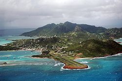
British Virgin Islands[]
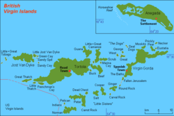
There are about 51 islands in the British Virgin Islands (16 inhabitated), including:[47][48]
- Anegada, 18°43′53″N 64°19′43″W / 18.73129°N 64.32873°W
- Beef Island, 18°26′30″N 64°31′47″W / 18.44175°N 64.52966°W
- Bellamy Cay, 18°26′53″N 64°31′58″W / 18.44798°N 64.53283°W
- (Rocks), 18°24′32″N 64°27′17″W / 18.40899°N 64.45483°W
- Buck Island, 18°25′27″N 64°33′30″W / 18.42418°N 64.55843°W
- Carvel Rock, 18°18′32″N 64°37′42″W / 18.30895°N 64.62829°W
- Cockroach Island, 18°29′41″N 64°27′49″W / 18.49475°N 64.46357°W
- Cooper Island, 18°22′43″N 64°30′36″W / 18.3786°N 64.50992°W
- Dead Chest, 18°21′56″N 64°33′47″W / 18.36548°N 64.56302°W
- East Seal Dog Island, 18°30′24″N 64°25′57″W / 18.50671°N 64.43241°W
- Eustatia Island, 18°30′38″N 64°21′30″W / 18.51046°N 64.35825°W
- Fallen Jerusalem Island, 18°25′04″N 64°27′04″W / 18.41777°N 64.45119°W
- Frenchman's Cay, 18°22′59″N 64°41′58″W / 18.38299°N 64.69943°W
- George Dog Island, 18°29′33″N 64°27′25″W / 18.49243°N 64.45683°W
- Ginger Island, 18°23′18″N 64°28′39″W / 18.38829°N 64.47747°W
- Great Camanoe, 18°43′40″N 64°19′43″W / 18.7277°N 64.32862°W
- Great Dog Island, 18°28′56″N 64°27′25″W / 18.48225°N 64.45696°W
- Great Thatch, 18°23′10″N 64°44′22″W / 18.38601°N 64.73947°W
- Great Tobago Island, 18°26′43″N 64°49′30″W / 18.44518°N 64.82513°W
- Green Cay, 18°27′13″N 64°42′31″W / 18.45362°N 64.70861°W
- Guana Island, 18°28′26″N 64°34′01″W / 18.47387°N 64.56699°W
- Jost Van Dyke, 18°26′55″N 64°44′37″W / 18.44859°N 64.74372°W
- Little Camanoe, 18°27′29″N 64°32′34″W / 18.45818°N 64.54266°W
- Little Jost Van Dyke, 18°27′16″N 64°43′14″W / 18.45443°N 64.72048°W
- Little Seal Dog Island
- Little Thatch, 18°22′54″N 64°42′52″W / 18.38173°N 64.71445°W
- Marina Cay, 18°27′40″N 64°31′31″W / 18.46101°N 64.52528°W
- Mosquito Island, 18°30′38″N 64°23′40″W / 18.51058°N 64.39435°W
- Mosquito Rock, 18°31′03″N 64°23′20″W / 18.51756°N 64.38898°W
- Nanny Cay (land-tied),18°23′56″N 64°38′02″W / 18.399°N 64.63392°W
- Necker Island, 18°31′37″N 64°21′30″W / 18.52682°N 64.35843°W
- Norman Island, 18°19′05″N 64°36′33″W / 18.31803°N 64.60918°W
- Pelican Island, 18°19′58″N 64°37′33″W / 18.33269°N 64.6257°W
- Peter Island, 18°21′15″N 64°34′44″W / 18.35404°N 64.57901°W
- Prickly Pear Island, 18°30′26″N 64°22′04″W / 18.5071°N 64.36787°W
- , 18°26′11″N 64°33′36″W / 18.43634°N 64.55989°W
- Round Rock, 18°23′55″N 64°27′28″W / 18.39849°N 64.45788°W
- Saba Rock, 18°30′11″N 64°21′28″W / 18.50319°N 64.35786°W
- Salt Island, 18°22′21″N 64°31′37″W / 18.37257°N 64.52695°W
- Sandy Cay, 18°26′10″N 64°42′35″W / 18.43601°N 64.70979°W
- Sandy Spit, 18°26′59″N 64°42′32″W / 18.44985°N 64.70887°W
- Scrub Island, 18°28′06″N 64°30′45″W / 18.46846°N 64.51245°W
- Tortola (largest island), 18°26′12″N 64°37′07″W / 18.43662°N 64.61849°W
- The Indians (rock), 18°19′57″N 64°37′44″W / 18.33249°N 64.62892°W
- Virgin Gorda, 18°27′43″N 64°25′35″W / 18.46202°N 64.42649°W
- West Seal Dog Island, 18°30′24″N 64°26′05″W / 18.5068°N 64.4346°W
- West Dog Island, 18°28′58″N 64°28′22″W / 18.4827°N 64.47275°W
- , 18°26′11″N 64°31′41″W / 18.43631°N 64.52808°W
Cayman Islands[]
The following are the islands of the Cayman Islands:[49]
- Cayman Brac, 19°43′00″N 79°49′00″W / 19.71667°N 79.81667°W
- Little Cayman Brac, 19°45′00″N 79°44′00″W / 19.75°N 79.73333°W
- First Cay
- Grand Cayman (largest island), 19°19′22″N 81°14′55″W / 19.32281°N 81.2487°W
- Barkers Cay
- Booby Cay, 19°20′00″N 81°18′00″W / 19.33333°N 81.3°W
- Duck Pond Cay, 19°18′N 81°18′W / 19.3°N 81.3°W
- Finger Cay/Dike (now absorbed into Grand Cayman), 19°21′00″N 81°16′00″W / 19.35°N 81.26667°W
- Sand Cay, 19°15′47″N 81°23′11″W / 19.26314°N 81.38625°W
- Water Cay (Point, now absorbed into Grand Cayman), 19°21′00″N 81°17′00″W / 19.35°N 81.28333°W
- Little Cayman, 19°41′00″N 80°03′00″W / 19.68333°N 80.05°W
- Owen Island, 19°39′59″N 80°03′45″W / 19.66643°N 80.0625°W
- Bessy Howard Cay, 19°45′00″N 79°43′00″W / 19.75°N 79.71667°W
- Vidal Cay, 19°23′00″N 81°21′00″W / 19.38333°N 81.35°W
Montserrat[]
There are only a few islands in Montserrat, including:[50]
- Montserrat (Largest island), 16°44′25″N 62°11′23″W / 16.7404°N 62.18983°W
- , 16°49′00″N 62°11′00″W / 16.81667°N 62.18333°W
- , 16°46′40″N 62°10′11″W / 16.77791°N 62.16985°W
Turks and Caicos Islands[]
The British Overseas Territory of the Turks and Caicos Islands is located in the Lucayan Archipelago, the portion of the Caribbean region in the North Atlantic Ocean rather than in or bordering the Caribbean Sea. There are about 75 islands and land-tied islands in Turks and Caicos Islands, including the following notable islands:[51]
- Big Ambergris Cay, 21°18′09″N 71°37′57″W / 21.30262°N 71.63238°W
- (Pear Cay), 21°22′22″N 71°05′22″W / 21.3729°N 71.08945°W
- East Caicos, 21°41′04″N 71°30′28″W / 21.68458°N 71.50776°W
- Grand Turk, 21°28′07″N 71°08′21″W / 21.46863°N 71.13922°W
- , 21°17′49″N 71°41′38″W / 21.2969°N 71.69383°W
- Mangrove Cay, 21°49′27″N 72°08′30″W / 21.82417°N 72.1418°W
- Middle Caicos, 21°47′51″N 71°43′40″W / 21.79756°N 71.72785°W
- North Caicos, 21°54′18″N 71°57′19″W / 21.90493°N 71.95521°W
- Parrot Cay, 21°55′10″N 72°03′34″W / 21.91941°N 72.05945°W
- , 21°11′00″N 71°41′00″W / 21.18333°N 71.68333°W
- Providenciales Island, 21°46′50″N 72°14′44″W / 21.78053°N 72.24554°W
- Salt Cay, 21°19′36″N 71°12′22″W / 21.3268°N 71.20617°W
- South Caicos, 21°30′28″N 71°31′14″W / 21.50766°N 71.52051°W
- West Caicos, 21°40′17″N 72°27′22″W / 21.67133°N 72.45621°W
Territories of the United States in the Caribbean[]
The following are disputed islands of the United States in the Caribbean:
- Navassa Island
- Serranilla Bank
- Bajo Nuevo Bank
The following sections show islands of island territories of the United States in the Caribbean.
Puerto Rico[]
There are about 142 island in Puerto Rico, including:[52]
- , 18°21′40″N 65°22′09″W / 18.36107°N 65.36905°W
- Bajo Evelyn (Evelyn Shoal), 18°09′14″N 65°44′31″W / 18.15382°N 65.74196°W
- Cabeza de Perro, 18°14′54″N 65°34′40″W / 18.24837°N 65.57766°W
- Cayo Ahogado, 18°19′21″N 65°37′10″W / 18.32245°N 65.61933°W
- Cayo Alfeñique, 17°55′37″N 66°21′07″W / 17.92691°N 66.35184°W
- Cayo Algodones, 18°11′34″N 65°41′01″W / 18.19274°N 65.68349°W
- Cayo Arenas, 17°57′35″N 66°40′27″W / 17.95969°N 66.67406°W
- Cayo Ballena, 18°20′51″N 65°14′13″W / 18.34746°N 65.23682°W
- Cayo Batata, 18°06′56″N 65°46′17″W / 18.11552°N 65.77127°W
- Cayo Bayo, 17°58′17″N 67°03′40″W / 17.97135°N 67.06101°W
- Cayo Berberia, 17°55′43″N 66°27′25″W / 17.92858°N 66.45684°W
- Cayo Botella, 18°19′30″N 65°14′27″W / 18.32496°N 65.24071°W
- Cayo Cabritas, 18°13′15″N 65°36′06″W / 18.22079°N 65.60155°W
- Cayo Caracoles, 17°57′36″N 67°02′18″W / 17.95997°N 67.03823°W
- Cayo Caribe, 17°58′12″N 66°43′58″W / 17.96997°N 66.73267°W
- Cayo Chiva, 18°06′21″N 65°24′58″W / 18.1058°N 65.41599°W
- Cayo Collado, 17°57′45″N 67°02′08″W / 17.96247°N 67.03546°W
- Cayo Corral, 17°56′09″N 67°01′10″W / 17.9358°N 67.01934°W
- Cayo Diablo, Fajardo, 18°21′45″N 65°31′53″W / 18.36245°N 65.53127°W
- Cayo Diable, Vieques, 18°07′20″N 65°18′29″W / 18.12228°N 65.30812°W
- Cayo Don Luis, 17°56′38″N 66°58′18″W / 17.94386°N 66.97157°W
- Cayo Enrique, 17°57′12″N 67°02′48″W / 17.9533°N 67.04657°W
- Cayo Fanduca, 18°05′13″N 67°12′54″W / 18.0869°N 67.2149°W
- Cayo Icacos, 18°23′11″N 65°35′20″W / 18.38634°N 65.58877°W
- Cayo Jalova, 18°07′07″N 65°21′32″W / 18.11858°N 65.35877°W
- Cayo Jalovita, 18°06′57″N 65°21′17″W / 18.1158°N 65.3546°W
- (Largo Shoals), 18°18′55″N 65°34′43″W / 18.31523°N 65.57849°W
- Cayo Lobito, 18°20′03″N 65°23′34″W / 18.33412°N 65.39266°W
- Cayo Lobo, 18°19′28″N 65°22′39″W / 18.32444°N 65.37750°W
- Cayo Lobos, 18°22′39″N 65°34′12″W / 18.37750°N 65.57000°W
- Cayo Maria Langa, 17°57′56″N 66°45′01″W / 17.96556°N 66.75028°W
- Cayo Mata - Guayanilla municipality, 17°59′21″N 66°45′49″W / 17.98917°N 66.76361°W
- Cayo Mata - Salinas municipality, 17°57′11″N 66°17′40″W / 17.95306°N 66.29444°W
- Cayo Mata Seca, 17°57′40″N 67°00′34″W / 17.96111°N 67.00944°W
- Cayo Matojo, 18°20′11″N 65°17′24″W / 18.33639°N 65.29000°W
- Cayo Morrillo, 17°55′37″N 66°16′23″W / 17.92694°N 66.27306°W
- Cayo Norte, 18°20′13″N 65°15′24″W / 18.3369°N 65.25655°W
- Cayo Palomas, 17°58′29″N 66°44′56″W / 17.97472°N 66.74889°W
- Cayo Parguera, 17°58′43″N 66°43′03″W / 17.97861°N 66.71750°W
- Cayo Piñerito, 18°14′42″N 65°35′41″W / 18.24500°N 65.59472°W
- Cayo Pirata, 18°18′23″N 65°17′44″W / 18.30639°N 65.29556°W
- Cayo Puerca, 17°55′46″N 66°14′13″W / 17.92944°N 66.23694°W
- Cayo Ratón, 18°18′51″N 65°21′12″W / 18.31417°N 65.35333°W
- Cayo Ratones - Fajardo municipality, 18°22′57″N 65°34′49″W / 18.38245°N 65.58016°W
- Cayo Real, 18°05′19″N 65°28′22″W / 18.08861°N 65.47278°W
- Cayo Rio, 17°58′57″N 66°44′17″W / 17.98250°N 66.73806°W
- Cayo Santiago, 18°09′23″N 65°44′03″W / 18.15635°N 65.73405°W
- Cayo Sombrerito, 18°20′16″N 65°14′44″W / 18.33778°N 65.24556°W
- Cayo Terremoto, 17°55′48″N 66°58′21″W / 17.93000°N 66.97250°W
- Cayo Tiburón, 18°20′42″N 65°14′17″W / 18.34500°N 65.23806°W
- Cayo Tuna, 18°20′15″N 65°23′35″W / 18.33750°N 65.39306°W
- Cayo Verde, 18°18′25″N 65°17′26″W / 18.30694°N 65.29056°W
- Cayo Vieques, 18°07′41″N 65°26′01″W / 18.12805°N 65.43351°W
- Cayo Yerba, 18°19′08″N 65°21′14″W / 18.31889°N 65.35389°W
- Cayo Luis Peña, 18°18′23″N 65°19′59″W / 18.30635°N 65.33294°W
- Cayo de Tierra, 18°05′20″N 65°28′02″W / 18.08889°N 65.46722°W
- Cayo del Agua, 18°18′40″N 65°20′51″W / 18.31111°N 65.34750°W
- Cayo del Agua, 18°18′43″N 65°20′52″W / 18.31194°N 65.34778°W
- Cayos Cabezazos, 17°55′18″N 66°22′59″W / 17.92167°N 66.38306°W
- Cayos Caribes, 17°55′38″N 66°12′44″W / 17.92722°N 66.21222°W
- Cayos de Barca, 17°54′59″N 66°14′23″W / 17.91639°N 66.23972°W
- Cayos de Caña Gorda, 17°56′32″N 66°52′17″W / 17.94219°N 66.87129°W
- Cayos de Caracoles, 17°55′42″N 66°21′59″W / 17.92833°N 66.36639°W
- Cayos de Pájaros, 17°55′24″N 66°15′40″W / 17.92333°N 66.26111°W
- Cayos de Ratones, 17°56′06″N 66°17′34″W / 17.93500°N 66.29278°W
- Cayos Geniqui, 18°20′18″N 65°13′54″W / 18.33833°N 65.23167°W
- El Ancón, 18°21′06″N 65°20′35″W / 18.35167°N 65.34306°W
- El Mono, 18°19′04″N 65°22′06″W / 18.31778°N 65.36833°W
- Isla Caja de Muertos, 17°53′41″N 66°31′12″W / 17.89472°N 66.52000°W
- Gata Islets, 17°58′00″N 66°37′00″W / 17.96667°N 66.61667°W
- Isla Culebrita, 18°18′53″N 65°13′44″W / 18.31472°N 65.22889°W
- Isla de Cardona, 17°57′26″N 66°38′06″W / 17.95722°N 66.63500°W
- Isla de Culebra, 18°18′53″N 65°16′59″W / 18.31472°N 65.28306°W
- Isla del Erio
- Isla Cabras, 18°12′44″N 65°36′09″W / 18.21222°N 65.60250°W
- Isla Chiva, 18°06′26″N 65°23′03″W / 18.10722°N 65.38417°W
- Isla Cueva, 17°57′44″N 67°04′49″W / 17.96222°N 67.08028°W
- Isla de Cerro Gordo, 18°29′11″N 66°20′56″W / 18.48639°N 66.34889°W
- Isla de Cabras, 18°12′44″N 65°36′09″W / 18.21222°N 65.60250°W
- Isla de las Palomas, 17°58′29″N 66°44′56″W / 17.97472°N 66.74889°W
- Isla de Ramos, 18°18′46″N 65°36′35″W / 18.31278°N 65.60972°W
- Isla Desecheo, 18°23′20″N 67°28′30″W / 18.38889°N 67.47500°W - Mayagüez municipality
- Isla Guachinanga, 18°25′48″N 66°02′08″W / 18.43000°N 66.03556°W
- Isla Guayacán, 17°57′27″N 67°05′25″W / 17.95750°N 67.09028°W
- Isla La Cancora, 18°27′57″N 65°59′51″W / 18.46583°N 65.99750°W
- Isla Magueyes, 17°58′08″N 67°02′39″W / 17.96889°N 67.04417°W
- Isla Matei, 17°58′04″N 67°00′28″W / 17.96778°N 67.00778°W
- Isla de Mona, 18°04′53″N 67°53′29″W / 18.08134°N 67.8913°W
- Isla Mata la Gata, 17°57′36.0″N 67°02′17.7″W / 17.960000°N 67.038250°W
- Isla Monito, 18°09′41″N 67°56′59″W / 18.16139°N 67.94972°W
- Isla Morrillito, 17°52′56″N 66°32′00″W / 17.88222°N 66.53333°W
- Isla Palominitos, 18°20′20″N 65°34′02″W / 18.33889°N 65.56722°W
- Isla Piedra
- Isla Puerca
- Isla San Juan
- Isla Yallis
- Isletas de Garzas
- Islote de Juan Perez
- Isla de Mona - Mayagüez municipality
- Isla de Ratones, Ponce
- Isla de Ratones (Cabo Rojo municipality)
- Isla de Vieques
- Isla Monito - Mayagüez municipality
- Islote Numero dos
- Isla Palominitos, 18°20′20″N 65°34′02″W / 18.33884°N 65.56711°W
- Isla Palominos, 18°20′55″N 65°34′05″W / 18.34861°N 65.56806°W
- Isla Piñeros, 18°15′08″N 65°35′29″W / 18.25222°N 65.59139°W
- La Blanquilla
- La Cordillera
- Las Cabritas
- Las Cucarachas
- Las Hermanas
- Las Lavanderas del Este
- Las Lavanderas del Oeste
- Los Farallones
- Los Gemelos
- Los Negritos
- Mata Redonda
- Pela
- Pelaita
- Penon Brusi
- Penon de Afuera
- Penon de San Jorge
- Piedra Stevens
- Piedra del Norte
- Piragua de Adentro
- Piragua de Afuera, 18°16′22″N 65°30′33″W / 18.27278°N 65.50917°W
- Puerto Rico (Boriken Island), 18°14′58″N 66°30′04″W / 18.2494°N 66.50101°W
- Punta Larga, 18°26′50″N 65°58′55″W / 18.44722°N 65.98194°W
- Punta Mosquitos, 18°26′41″N 65°58′33″W / 18.44472°N 65.97583°W
- Roca Alcatraz, 18°07′24″N 65°18′04″W / 18.12333°N 65.30111°W
- Roca Cocinera, 18°28′48″N 66°42′14″W / 18.48000°N 66.70389°W
- Roca Cucaracha, 18°09′17″N 65°19′22″W / 18.15472°N 65.32278°W
- Roca Culumna, 18°19′58″N 65°23′31″W / 18.33278°N 65.39194°W
- Roca Ola, 17°56′51″N 67°10′56″W / 17.94750°N 67.18222°W
- Roca Resuello, |18°28′42″N 66°43′06″W / 18.47833°N 66.71833°W
- Roca Speck, 18°19′35″N 65°15′50″W / 18.32639°N 65.26389°W
- Roca Velásquez, 18°01′24″N 67°10′40″W / 18.02333°N 67.17778°W
- Tres Hermanas, 18°29′28″N 66°34′28″W / 18.49111°N 66.57444°W
- Tres Hermanos, 18°28′54″N 66°42′12″W / 18.48167°N 66.70333°W
United States Virgin Islands[]
There are about 84 islands in the United States Virgin Islands, including:[53]
- Barrel of Beef, 18°18′48″N 64°54′53″W / 18.31334°N 64.9148°W
- Blinders Rocks, 18°20′39″N 64°40′58″W / 18.34412°N 64.68291°W
- Booby Rock, 18°18′08″N 64°42′35″W / 18.30218°N 64.70986°W
- Bovoni Cay, 18°18′44″N 64°52′20″W / 18.31218°N 64.87209°W
- Buck Island - Saint Croix, 17°47′13″N 64°37′10″W / 17.78692°N 64.61931°W
- Buck Island - Saint Thomas, 18°16′39″N 64°53′38″W / 18.27745°N 64.89375°W
- Calf Rock, 18°18′15″N 64°50′44″W / 18.30412°N 64.84542°W
- Capella Islands, 18°24′51″N 64°54′29″W / 18.41412°N 64.90792°W
- Carval Rock or Carvel Rock, 18°22′11″N 64°47′40″W / 18.36968°N 64.79431°W
- Cas Cay, 18°18′25″N 64°51′55″W / 18.3069°N 64.86514°W
- Cinnamon Cay, 18°21′23″N 64°45′23″W / 18.35634°N 64.75631°W
- Cockroach Island, 18°24′14″N 65°03′38″W / 18.40385°N 65.06043°W
- Coculus Rock, 18°18′50″N 64°51′39″W / 18.31384°N 64.8607°W
- Cololoba Cay, 18°18′55″N 64°45′37″W / 18.31523°N 64.76014°W
- Congo Cay, 18°22′04″N 64°48′10″W / 18.36773°N 64.80264°W
- Cow Rock, 18°18′14″N 64°50′50″W / 18.30384°N 64.84736°W
- Cricket Rock, 18°24′30″N 65°02′58″W / 18.40829°N 65.04932°W
- Current Rock, 18°18′54″N 64°50′04″W / 18.31495°N 64.83431°W
- Dog Island, 18°17′45″N 64°48′56″W / 18.29579°N 64.81569°W
- Dog Rocks, 18°17′42″N 64°48′44″W / 18.29495°N 64.81236°W
- Domkirk Rock, 18°20′06″N 65°05′04″W / 18.33496°N 65.08432°W
- Dry Rock, 18°18′06″N 65°00′36″W / 18.30153°N 65.01003°W
- Durloe Cays, 18°21′13″N 64°47′35″W / 18.35356°N 64.79319°W
- Dut Cheap Cay
- Fish Cay, 18°18′35″N 64°49′58″W / 18.30968°N 64.83264°W
- Flanagan Island, 18°19′36″N 64°39′01″W / 18.32662°N 64.65014°W[54]
- Flat Cays, 18°19′01″N 64°59′21″W / 18.31703°N 64.9892°W
- Gorret Rock, 18°22′40″N 65°03′50″W / 18.37773°N 65.06376°W
- Grass Cay, 18°21′33″N 64°49′58″W / 18.35912°N 64.83264°W
- Great Saint James Island, 18°18′35″N 64°49′44″W / 18.30968°N 64.82875°W
- Green CaySaint Croix, 17°46′01″N 64°39′57″W / 17.76692°N 64.6657°W
- Green Cay - Saint Thomas, 18°18′37″N 64°54′29″W / 18.31023°N 64.90792°W
- Hans Lollik Island, 18°23′53″N 64°54′29″W / 18.39801°N 64.90792°W
- Hans Lollik Rock, 18°23′04″N 64°54′02″W / 18.3844°N 64.90042°W
- Hassel Island, 18°19′46″N 64°56′08″W / 18.3294°N 64.93542°W
- Henley Cay, 18°21′13″N 64°47′35″W / 18.35356°N 64.79319°W
- Inner Brass Island, 18°22′59″N 64°58′15″W / 18.38301°N 64.9707°W
- Kalkun Cay, 18°21′02″N 65°03′28″W / 18.35051°N 65.05765°W
- Leduck Island, 18°18′59″N 64°41′16″W / 18.31634°N 64.68791°W
- Limestone Rock, 18°19′04″N 64°56′47″W / 18.31773°N 64.94626°W
- Little Hans Lollik Island, 18°24′33″N 64°54′29″W / 18.40912°N 64.90792°W
- Harvey Island (Saint Croix), 17°41′02″N 64°45′42″W / 17.68386°N 64.76153°W
- Little Saint James Island, 18°18′00″N 64°49′31″W / 18.29995°N 64.82514°W
- Lizard Rocks, 18°23′09″N 64°59′24″W / 18.38579°N 64.98987°W
- Lovango Cay, 18°21′45″N 64°48′13″W / 18.36245°N 64.80375°W
- Mingo Cay, 18°21′35″N 64°49′13″W / 18.35968°N 64.82014°W
- Outer Brass Island, 18°23′41″N 64°58′16″W / 18.39468°N 64.97098°W
- Packet Rock, 18°17′59″N 64°53′26″W / 18.29968°N 64.89042°W
- Patricia Cay, 18°18′25″N 64°52′19″W / 18.3069°N 64.87181°W
- Pelican Cay, 18°24′51″N 64°54′29″W / 18.41412°N 64.90792°W
- Perkins Cay, 18°21′15″N 64°46′38″W / 18.35412°N 64.77736°W
- Porpoise Rocks, 18°18′30″N 64°58′21″W / 18.30833°N 64.97243°W
- Protestant Cay, 17°44′59″N 64°42′10″W / 17.7497°N 64.70264°W
- Ramgoat Cay, 18°21′19″N 64°47′22″W / 18.35523°N 64.78931°W
- Rata Cay, 18°21′22″N 64°47′49″W / 18.35606°N 64.79681°W
- Rotto Cay, 18°18′51″N 64°51′52″W / 18.31412°N 64.86431°W
- Rupert Rock, 18°19′42″N 64°55′34″W / 18.32829°N 64.92598°W
- Ruth Island, 17°41′03″N 64°45′41″W / 17.68414°N 64.76126°W
- Saba Island, 18°18′19″N 65°00′02″W / 18.30528°N 65.00047°W
- Saint Croix, 17°43′52″N 64°47′30″W / 17.73103°N 64.79153°W
- Saint John, 18°20′32″N 64°44′35″W / 18.34231°N 64.74295°W
- Saint Thomas, 18°21′02″N 64°55′25″W / 18.35062°N 64.92353°W
- Salt Cay, 18°21′43″N 65°02′59″W / 18.3619°N 65.0496°W
- Saltwater Money Rock, 18°20′41″N 65°02′57″W / 18.34468°N 65.04904°W
- Sandy Point Rock, 18°19′46″N 64°56′48″W / 18.3294°N 64.94653°W
- Savana Island, 18°20′22″N 65°04′45″W / 18.33944°N 65.07917°W
- Shark Island, 18°20′14″N 64°50′40″W / 18.33718°N 64.84458°W
- Skipper Jacob Rock, 18°19′44″N 64°48′17″W / 18.32884°N 64.80486°W
- Steven Cay, 18°19′50″N 64°48′25″W / 18.33051°N 64.80708°W
- The Stragglers, 18°18′12″N 64°50′08″W / 18.30329°N 64.83542°W
- Sula Cay, 18°24′11″N 65°03′30″W / 18.40301°N 65.05821°W
- Thatch Cay, 18°21′33″N 64°51′39″W / 18.35912°N 64.86097°W
- Triangle Islands, 18°18′49″N 64°55′01″W / 18.31357°N 64.91681°W
- Trunk Cay, 18°21′19″N 64°46′09″W / 18.35523°N 64.76903°W
- Turtleback Rock, 18°20′49″N 64°51′30″W / 18.3469°N 64.8582°W
- Turtledove Cay, 18°18′31″N 65°00′02″W / 18.30859°N 65.00054°W
- Two Brothers, 18°20′35″N 64°49′01″W / 18.34301°N 64.81708°W
- Water Island, 18°19′16″N 64°57′07″W / 18.32104°N 64.95181°W
- Waterlemon Cay, 18°22′01″N 64°43′24″W / 18.3669°N 64.72347°W
- Welk Rocks, 18°18′23″N 64°49′15″W / 18.30634°N 64.82097°W
- West Cay, 18°21′33″N 65°02′45″W / 18.35912°N 65.04571°W
- Whistling Cay, 18°22′13″N 64°45′14″W / 18.37023°N 64.75375°W
Saint Thomas, Saint Croix, Saint John, and Water Island are the main four United States Virgin Islands. The capital, Charlotte Amalie, is on Saint Thomas.
Islands of the State of Florida[]
While not technically part of the Caribbean, the islands of the Florida in the United States are considered by some to be part of the greater Caribbean Region. Regions of Florida include: South Florida, Southwest Florida, and the Florida Keys.
- Key West, 24°33′17″N 81°47′29″W / 24.55459°N 81.79148°W
- Key Largo, 25°10′49″N 80°21′58″W / 25.1804°N 80.36617°W
- Stock Island, 24°34′22″N 81°44′26″W / 24.57265°N 81.74065°W
Venezuela[]
The following islands of Venezuela are in the Caribbean Sea:
- Archipiélago Las Aves
- Isla La Blanquilla, 11°50′57″N 64°36′06″W / 11.84926°N 64.60171°W
- Archipiélago Los Monjes, 12°25′00″N 70°55′00″W / 12.41667°N 70.91667°W
- Archipiélago Los Roques, 11°50′00″N 66°45′00″W / 11.83333°N 66.75°W
- Isla de Aves, 15°40′07″N 63°37′05″W / 15.66861°N 63.61796°W
- Isla de Coche, 10°46′38″N 63°55′52″W / 10.77723°N 63.9312°W
- Isla de Cubagua, 10°48′42″N 64°11′35″W / 10.81173°N 64.19314°W
- Isla de Patos, 10°38′22″N 61°51′50″W / 10.63934°N 61.86382°W
- Isla de Toas, 10°57′23″N 71°39′17″W / 10.95651°N 71.65469°W
- . 10°58′25″N 71°33′28″W / 10.973743511924201°N 71.55771106621476°W[10]
- Isla La Orchila, 11°47′45″N 66°08′17″W / 11.79584°N 66.13812°W
- Isla La Sola, 11°18′39″N 63°34′14″W / 11.31084°N 63.57053°W
- Isla La Tortuga, 10°56′00″N 65°20′00″W / 10.93333°N 65.33333°W
- Isla Margarita, 10°59′13″N 63°56′08″W / 10.98705°N 63.93568°W
- , 11°02′21″N 71°42′39″W / 11.03927°N 71.71081°W
- Islas los Frailes, 11°12′50″N 63°44′29″W / 11.21376°N 63.74143°W
- Islas Caracas, 10°22′24″N 64°26′47″W / 10.37337°N 64.44648°W
- Islas los Hermanos, 11°46′31″N 64°24′18″W / 11.7753°N 64.40489°W
- Islas los Testigos, 11°21′58″N 63°06′37″W / 11.36608°N 63.11029°W
See also[]
| Wikimedia Commons has media related to Category:Islands of the Caribbean region. |
- List of Caribbean islands by area
- List of Caribbean island countries by population
- List of metropolitan areas in the West Indies
- List of Caribbean islands by political affiliation
- List of islands by population density
- List of West Indian First-level Subdivisions
- Low island (island of coral origin), Coral island
References[]
- ^ "Islands of Antigua and Barbuda". GeoNames. Retrieved September 22, 2021.
- ^ Antigua & barbuda investment and trade laws and regulations handbook. International Business Publications USA. 2008. p. 9. ISBN 978-1-4330-7538-4. OCLC 946496096.
- ^ Birdlife International (2020). "Important Bird Areas factsheet: Offshore Islands". BirdLife Data Zone. Retrieved 2020-06-16.
- ^ Ecoengineering Caribbean Limited (July 31, 2007). "NORTHEAST MARINE MANAGEMENT AREA (NEMMA), ANTIGUA SITE REPORT ECO REPORT No. 10/2007" (PDF). Retrieved 16 June 2020.
- ^ "Islands of the Bahamas". GeoNames. Retrieved September 30, 2021.
- ^ "Overview of The Bahamas". Government of the Bahamas. Retrieved October 10, 2021.
- ^ "Barbados Islands". GeoNames. Retrieved September 22, 2021.
- ^ "Islands of Belize". GeoNames. Retrieved September 28, 2021.
- ^ a b c d e f "Colombian Islands". GeoNames. Retrieved September 22, 2021.
- ^ a b c d e f Google Maps
- ^ "Islands of Costa Rica". GeoNames. Retrieved September 29, 2021.
- ^ Mapping Interactivo (March 2005). "Mangroves variability in the Sabana-Camaguay Archipellago". Archived from the original on 2007-08-08. Retrieved 2007-10-16.
- ^ "Islands of Cuba". GeoNames.
- ^ "Islands of Dominica". GeoNames. Retrieved September 23, 2021.
- ^ "Dominca". CIA Factbook, U.S. Central Intelligence Agency. Retrieved September 25, 2021.
- ^ "Islands of the Dominican Republic". GeoNameaccess-date=September 26, 2021.
- ^ "CIA World Factbook (2006) – Guadeloupe". Retrieved 27 July 2019.
- ^ "Islands of Guadeloupe". GeoNames. Retrieved September 27, 2021.
- ^ "Islands of Martinique". GeoNames. Retrieved September 29, 2021.
- ^ "Islands of Saint Barthélemy". GeoName. Retrieved September 29, 2021.
- ^ a b "Draft organic law on statutory and institutional provisions relating to overseas territories, Archived copy". Legislative Files, Governemtn of France. Archived from the original on 2008-04-12. Retrieved 2008-01-10.
- ^ "Islands of Grenada". GeoNames. Retrieved October 1, 2021.
- ^ Haggerty, Richard A.; Hornbeck, John F. (1987). "Grenada: Geography". In Meditz, Sandra W.; Hanratty, Dennis M. (eds.). Islands of the Commonwealth Caribbean: a regional study. Washington, D.C.: Federal Research Division, Library of Congress. pp. 349–351. OCLC 49361510.
 This article incorporates text from this source, which is in the public domain.CS1 maint: postscript (link)
- ^ "Islands of Haiti". GeoNames. Retrieved September 27, 2021.
- ^ "Is This the Most Crowded Island in the World? (And Why That Question Matters)". Longreads.
- ^ a b c d Anastil, Lancelot (2010). C'est La Vie. p. 33. ISBN 9781456811648. Retrieved 23 April 2015.
- ^ a b c d Bellegarde, Serge (October 1998). "Navassa Island: Haiti and the U.S. – A Matter of History and Geography". windowsonhaiti.com. Retrieved February 6, 2008.
- ^ a b c d "Haiti: Constitution, 1987 (English translation)".
- ^ a b c Augier, Dominique; Watson, Patrick, eds. (2015). Etudes Caribéennes n°15: Ressources marines: états des lieux, usages et gestion Vol. 5, 15. p. 187. ISBN 9782342034318. Retrieved 23 April 2015.
- ^ Ile Grosse Caye, Haiti / Sud / Aquin
- ^ "Ile Grosse Caye". GeoNames. Retrieved September 27, 2021.
- ^ "Islands of the Honduras". GeoNames. Retrieved September 28, 2021.
- ^ "Islands of Jamaica". GeoNames. Retrieved September 28, 2021.
- ^ "Islands of Aruba". GeoNames. Retrieved October 1, 2021.
- ^ "Islands of Curaçao". GeoNames. Retrieved October 1, 2021.
- ^ "Islands of Sint Maarten". GeoNames. Retrieved October 1, 2021.
- ^ a b c d e f g h i j k l m "List of islands of the Netherlands". Visit Holland. Retrieved October 4, 2021.
- ^ Google Maps
- ^ "Islands of Mexico". GeoNames. Retrieved October 3, 2021.
- ^ "Islands of Nicaragua". GeoNames. Retrieved October 5, 2021.
- ^ "Islands of Panama". GeoNames. Retrieved October 3, 2021.
- ^ "Saint Kitts and Nevis islands". GeoNames. Retrieved October 3, 2021. (only lists three islands)
- ^ "Islands of Saint Lucia". GeoNames. Retrieved October 2, 2021.
- ^ "Islands of Saint Vincent and the Grenadines". GeoName. Retrieved October 3, 2021.
- ^ "Islands of Trinidad and Tobago". GeoNames. Retrieved October 3, 2021.
- ^ "Islands of Anguilla". GeoNames. Retrieved October 3, 2021.
- ^ "Islands of the British Virgin Islands". GeoNames. Retrieved October 3, 2021.
- ^ "British Virgin Islands". The World Factbook. Central Intelligence Agency. Retrieved 9 July 2021.
- ^ "Islands of the Cayman Islands". GeoNames. Retrieved September 29, 2021.
- ^ "Islands of Monserrat". GeoNames. Retrieved October 3, 2021.
- ^ "Islands of Turks and Caicos Islands". GeoNames. Retrieved September 30, 2021.
- ^ "Islands of Puerto Rico". GeoNames. Retrieved October 3, 2021.
- ^ "Islands of the U.S. Virgin Islands". GeoNames. Retrieved October 3, 2021.
- ^ "Full text of "Convention on the Conservation and Management of Pollock Resources in the Central Bering Sea (Treaty doc. 103-27) and two treaties with the United Kingdom establishing Caribbean maritime boundaries (Treaty doc. 103-23) : hearing before the Committee on Foreign Relations, United States Senate, One Hundred Third Congress, second session, September 28, 1994"". Archive.org. Retrieved 30 August 2017.
- "United Nations Island Directory". United Nations. Retrieved October 3, 2021.
- Caribbean islands
- Caribbean-related lists
- West Indies
- Lists of islands by sea