List of Docklands Light Railway stations

From Wikipedia, the free encyclopedia

Map of the Docklands Light Railway network

The Docklands Light Railway (DLR) is an automated light metro system that serves the London Docklands area of east and south-east London. First opened on 31 August 1987, the DLR was a key component in the regeneration of large areas of disused industrial land into valuable commercial and residential districts.[1]

The system been extended multiple times, and now reaches north to Stratford, south to Lewisham, west to Tower Gateway and Bank in the City of London financial district, and east to Beckton, London City Airport and Woolwich Arsenal.

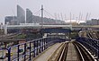
Stations are in the City of London and the boroughs of Newham, Tower Hamlets, Greenwich and Lewisham with the majority of the network north of the River Thames. Of the 45 stations, four are underground: Woolwich Arsenal, Island Gardens, Bank and Cutty Sark (for maritime Greenwich).

Map all coordinates using: OpenStreetMap 
Download coordinates as: KML

Stations and routes[]

Listed for each station is the branch or branches it is on, the local authority, the London Travelcard zone in which it is located, interchanges with other modes of transport, the opening date and any resiting.

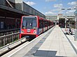
Four stations have direct interchanges with London Underground lines: Bank (Central, Circle, District, Northern and Waterloo & City), Canning Town (Jubilee), West Ham (Hammersmith & City, Jubilee and District lines) and Stratford (Central and Jubilee). There are indirect interchanges at Canary Wharf and Heron Quays (for Jubilee line from Canary Wharf), Bow Church (for District and Hammersmith & City lines from Bow Road) and Tower Gateway (for Circle and District lines from Tower Hill). There are interchanges with London Overground at Stratford (direct) and Shadwell (indirect). There are interchanges with National Rail at Greenwich, Lewisham, Limehouse, Woolwich Arsenal, Stratford, West Ham and Stratford International.[2]
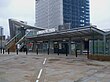
List[]

Station Image Local Authority Zone(s) Opened[note 1] Other names[note 2] Usage (millions)[3][note 3] Coordinates Notes
Abbey Road Abbey Road stn look north.jpg Newham
3
31 August 2011[4][5]
1.204
51°31′55.20″N 0°0′14.4″E / 51.5320000°N 0.004000°E / 51.5320000; 0.004000 (Abbey Road DLR station)
All Saints All Saints DLR stn look south.JPG Tower Hamlets
2
31 August 1987[6]
Poplar High Street, East India Docks Road[7]
2.160
51°30′39″N 0°00′47″W / 51.51083°N 0.01306°W / 51.51083; -0.01306 (All Saints DLR station) On the site of Poplar (East India Road) station (1866–1944)[8][9]
Bank Bank station DLR platform 9 look west.JPG City of London
1
1 July 1991[10][11]
32.256
51°30′46.80″N 0°5′16.80″W / 51.5130000°N 0.0880000°W / 51.5130000; -0.0880000 (Bank–Monument station)
Monument station first opened in 1884, Bank station in 1900.
Beckton Beckton DLR platform 2.jpg Newham
3
28 March 1994[6]
2.569
51°30′53″N 0°03′41″E / 51.51472°N 0.06139°E / 51.51472; 0.06139 (Beckton DLR station)
Beckton Park Beckton Park stn eastbound.JPG Newham
3
28 March 1994[6]
0.456
51°30′32″N 0°03′18″E / 51.50889°N 0.05500°E / 51.50889; 0.05500 (Beckton Park)
Blackwall Blackwall DLR station, from below geograph-3263884-by-Ben-Brooksbank.jpg Tower Hamlets
2
28 March 1994[6]
1.834
51°30′28.5″N 0°0′26″W / 51.507917°N 0.00722°W / 51.507917; -0.00722 (Blackwall DLR station) Near the site of Poplar railway station (1840–1926)[8][9]
Bow Church Bow Church DLR Station Entrance.jpg Tower Hamlets
2
31 August 1987[6]
Bow Road[7]
3.645
51°31′39″N 0°1′14.88″W / 51.52750°N 0.0208000°W / 51.52750; -0.0208000 (Bow Church DLR station) On the site of Bow railway station (1850–1944)[8][9]
Canary Wharf Canary Wharf DLR Station - geograph.org.uk - 434859.jpg Tower Hamlets
2
November 1991[12] [13][14]
Canary Quay[15]
19.359
51°30′18.36″N 0°1′15.24″W / 51.5051000°N 0.0209000°W / 51.5051000; -0.0209000 (Canary Wharf DLR station) Construction did not begin until after the original line opened, as the Canary Wharf development was not ready.[12]
Canning Town
(High Level)
Canning Town Station - geograph.org.uk - 441856.jpg Newham
3
5 March 1998[16][17]
16.382
51°30′50″N 0°0′29″E / 51.51389°N 0.00806°E / 51.51389; 0.00806 (Canning Town station) Due to Jubilee Line extension construction, DLR platforms did not open with the rest of the Beckton extension.[18] Original station opened 1847.[8]
Canning Town
(Low Level)
Canning Town stn DLR Stratford International branch northbound look north.jpg Newham
3
31 August 2011[4][5]
6.537
51°30′50″N 0°0′31″E / 51.51389°N 0.00861°E / 51.51389; 0.00861 (Canning Town station) On site of North London Line platforms (1847–2006)[8]
Crossharbour Crossharbour DLR station MMB 04.jpg Tower Hamlets
2
31 August 1987[6]
East Ferry Road, Glengall Grove,[19] Crossharbour & London Arena[8]
4.050
51°29′44.87″N 0°0′52.17″W / 51.4957972°N 0.0144917°W / 51.4957972; -0.0144917 (Crossharbour DLR station) On the site of Millwall Docks railway station (1871–1926)[8]
Custom House for ExCeL Custom House DLR westbound platform.jpg Newham
3
28 March 1994[6]
Custom House
3.383
51°30′34.7″N 0°1′33.22″E / 51.509639°N 0.0258944°E / 51.509639; 0.0258944 (Custom House station) Original station opened 1855–2006.[8] Previously Custom House, prior to the opening of ExCeL London.
Cutty Sark for Maritime Greenwich Cutty Sark DLR station entrance.jpg Greenwich
2 & 3
3 December 1999[6]
Cutty Sark, Greenwich Town[20]
7.513
51°28′54.13″N 0°0′39.28″W / 51.4817028°N 0.0109111°W / 51.4817028; -0.0109111 (Cutty Sark DLR station)
Cyprus Cyprus station eastbound.JPG Newham
3
28 March 1994[6]
1.482
51°30′31″N 0°03′50″E / 51.50861°N 0.06389°E / 51.50861; 0.06389 (Cyprus DLR station)
Deptford Bridge Deptford Bridge DLR station from a southbound train 2005-12-10.jpg Lewisham
2 & 3
20 November 1999[6]
Deptford Creek[20]
4.650
51°28′27.84″N 0°1′21″W / 51.4744000°N 0.02250°W / 51.4744000; -0.02250 (Deptford Bridge DLR station)
Devons Road Devons Road DLR station - East London.jpg Tower Hamlets
2
31 August 1987[6]
2.553
51°31′20″N 0°01′2.5″W / 51.52222°N 0.017361°W / 51.52222; -0.017361 (Devons Road DLR station)
East India EastindiaDLR.jpg Tower Hamlets
2 & 3
28 March 1994[6]
Brunswick, Brunswick Wharf[21]
3.765
51°30′33.48″N 0°0′7.56″W / 51.5093000°N 0.0021000°W / 51.5093000; -0.0021000 (East India DLR station)
Elverson Road Elverson Road DLR station - roof detail - geograph.org.uk - 1081511.jpg Greenwich
2 & 3
20 November 1999[6]
1.954
51°28′7.19″N 0°0′58.93″W / 51.4686639°N 0.0163694°W / 51.4686639; -0.0163694 (Elverson Road DLR station)
Gallions Reach Gallions Reach station geograph-3555558-by-Ben-Brooksbank.jpg Newham
3
28 March 1994[6]
1.122
51°30′32″N 0°04′18″E / 51.50889°N 0.07167°E / 51.50889; 0.07167 (Gallions Reach DLR station)
Greenwich Greenwich, railway station façade - geograph.org.uk - 1498366.jpg Greenwich
2 & 3
20 November 1999[6]
5.415
51°28′41.16″N 0°0′50.4″W / 51.4781000°N 0.014000°W / 51.4781000; -0.014000 (Greenwich DLR station) Original station opened 1838[8]
Heron Quays Heron Quays DLR station MMB 01 28.jpg Tower Hamlets
2
31 August 1987[6]
Heron Wharf[15]
8.291
51°30′10.52″N 0°1′17.65″W / 51.5029222°N 0.0215694°W / 51.5029222; -0.0215694 (Heron Quays DLR station) Resited in 2002 when new development opened[13]
Island Gardens Island Gardens stn entrance.JPG Tower Hamlets
2
31 August 1987[6]
North Greenwich, Cubitt Town[19]
2.997
51°29′16.9″N 0°0′37.8″W / 51.488028°N 0.010500°W / 51.488028; -0.010500 (Island Gardens DLR station) The position planned before the railway originally opened was on the other side of Manchester Road.[22] The station was relocated underground with the opening of the Lewisham extension on 20 November 1999.[6]
King George V London DLR King George V Station.jpg Newham
3
2 December 2005[23]
North Woolwich[24]
1.645
51°30′7.1″N 0°3′46″E / 51.501972°N 0.06278°E / 51.501972; 0.06278 (King George V DLR station) Originally, the route was to terminate at City Airport.[24]
Langdon Park Langdon Park DLR stn east entrance.JPG Tower Hamlets
2
9 December 2007[13][25]
Fawe Street, Carmen Street[15]
3.910
51°30′54″N 0°0′50.4″W / 51.51500°N 0.014000°W / 51.51500; -0.014000 (Langdon Park DLR station) Station safeguarded since original railway opened.[12] To the south of South Bromley railway station (1884–1944)[8]
Lewisham Lewisham DLR stn look north.JPG Lewisham
2 & 3
20 November 1999[6]
11.468
51°27′55.08″N 0°0′47.88″W / 51.4653000°N 0.0133000°W / 51.4653000; -0.0133000 (Lewisham station) Original station opened 1849.[8]
Limehouse DLR Limehouse from Ratcliffe Lane, London E14 - geograph.org.uk - 804673.jpg Tower Hamlets
2
31 August 1987[6]
Stepney East[19]
9.087
51°30′44.64″N 0°2′22.92″W / 51.5124000°N 0.0397000°W / 51.5124000; -0.0397000 (Limehouse station) Original station opened 1840[8]
London City Airport London City Airport DLR Station.jpg Newham
3
2 December 2005[23]
4.526
51°30′13″N 0°2′56″E / 51.50361°N 0.04889°E / 51.50361; 0.04889 (London City Airport DLR station) Drew Primary School had to be demolished and relocated so land could be used for the construction of the station.[26]
Mudchute Mudchute DLR stn looking north.JPG Tower Hamlets
2
31 August 1987[6]
Millwall Park, East Ferry Road[7]
2.314
51°29′27.23″N 0°0′52.95″W / 51.4908972°N 0.0147083°W / 51.4908972; -0.0147083 (Mudchute DLR station) Station relocated on 20 November 1999 due to the Lewisham extension opening.[6]
Pontoon Dock Pontoon Dock stn southern entrance.JPG Newham
3
2 December 2005[23]
1.174
51°30′8″N 0°1′55″E / 51.50222°N 0.03194°E / 51.50222; 0.03194 (Pontoon Dock DLR station)
Poplar London MMB R3 Docklands Light Railway.jpg Tower Hamlets
2
31 August 1987[6]
3.047
51°30′27.77″N 0°1′1.99″W / 51.5077139°N 0.0172194°W / 51.5077139; -0.0172194 (Poplar DLR station)
Prince Regent Prince Regent stn eastbound.JPG Newham
3
28 March 1994[6]
Prince Regent Lane[27]
3.092
51°30′34.01″N 0°2′0.36″E / 51.5094472°N 0.0334333°E / 51.5094472; 0.0334333 (Prince Regent DLR station)
Pudding Mill Lane Pudding Mill Lane DLR stn look west.JPG Newham
2 & 3
15 January 1996[12][28]
Marshgate Lane[29]
0.769
51°32′2.76″N 0°0′49.68″W / 51.5341000°N 0.0138000°W / 51.5341000; -0.0138000 (Pudding Mill Lane DLR station) Station safeguarded since original railway opening.[12] The station was resited and rebuilt on a new alignment on 28 April 2014 as the old site was required for a Crossrail tunnel portal.[30]
Royal Albert Royal Albert stn eastbound.JPG Newham
3
28 March 1994[6]
1.655
51°30′31″N 0°02′47″E / 51.50861°N 0.04639°E / 51.50861; 0.04639 (Royal Albert DLR station)
Royal Victoria Royal Victoria DLR station.jpg Newham
3
28 March 1994[6]
4.279
51°30′33.04″N 0°1′4.84″E / 51.5091778°N 0.0180111°E / 51.5091778; 0.0180111 (Royal Victoria DLR station) East of the site of Tidal Basin railway station (1858–1943)[8]
Shadwell Shadwell DLR stn look west.JPG Tower Hamlets
2
31 August 1987[6]
9.014
51°30′42.16″N 0°3′22.17″W / 51.5117111°N 0.0561583°W / 51.5117111; -0.0561583 (Shadwell DLR station) On the site of Shadwell and St George's East railway station (1840–1941)[8]
South Quay South Quay new DLR stn from south.JPG Tower Hamlets
2
31 August 1987[6]
Cuba Street[15]
5.938
51°30′0.31″N 0°0′58.44″W / 51.5000861°N 0.0162333°W / 51.5000861; -0.0162333 (South Quay DLR station) Between 12 February and 15 April 1996 there was no service south of Canary Wharf due to a bombing near South Quay.[6] The station was resited to make platform extensions easier as the previous site had tight curves at either end. It was resited on 26 October 2009.[31]
Star Lane Star Lane stn west entrance.jpg Newham
3
31 August 2011[4][5]
Cody Road[32]
1.434
51°31′14.52″N 0°0′15.12″E / 51.5207000°N 0.0042000°E / 51.5207000; 0.0042000 (Star Lane DLR station)
Stratford
(High Level)
Stratford DLR 4a 4b w.JPG Newham
3
31 August 1987[6]
9.365
51°32′27″N 0°0′15″W / 51.54083°N 0.00417°W / 51.54083; -0.00417 (Stratford Regional station) Original station opened 1839[8] Resited in 2007.[13]
Stratford
(Low Level)
Stratford station DLR Stratford International branch look north.jpg Newham
3
31 August 2011[4][5]
10.337
51°32′27″N 0°0′11″W / 51.54083°N 0.00306°W / 51.54083; -0.00306 (Stratford Regional station) On site of North London Line platforms (1846–2006)[8]
Stratford High Street Stratford High Street stn high southbound.jpg Newham
3
31 August 2011[4][5]
Stratford Market[32]
1.144
51°32′16.44″N 0°0′2.16″W / 51.5379000°N 0.0006000°W / 51.5379000; -0.0006000 (Stratford High Street DLR station) On site of Stratford Market station (1847–1957)[8]
Stratford International Stratford International DLR stn platform 2 look west..jpg Newham
3
31 August 2011[4][5]
3.195
51°32′41.28″N 0°0′30.96″W / 51.5448000°N 0.0086000°W / 51.5448000; -0.0086000 (Stratford International station) National Rail station opened 2009[8]
Tower Gateway DLR tower gateway.jpg City of London
1
31 August 1987[6]
Tower Hill, Minories[19]
4.101
51°30′38.2″N 0°4′29.18″W / 51.510611°N 0.0747722°W / 51.510611; -0.0747722 (Tower Gateway DLR station) Options before the railway opened included a separate terminus for Tower Hill and a tunnelled terminus at Aldgate East[22]
West Ham DLR unit 33 at West Ham.jpg Newham
3
31 August 2011[4][5]
3.187
51°31′40.8″N 0°0′14.4″E / 51.528000°N 0.004000°E / 51.528000; 0.004000 (West Ham station) Original station opened 1901[8]
West India Quay West India Quay DLR stn look south.JPG Tower Hamlets
2
31 August 1987[6]
West India Dock, North Quay[15]
1.357
51°30′24.9″N 0°1′13.78″W / 51.506917°N 0.0204944°W / 51.506917; -0.0204944 (West India Quay DLR station)
West Silvertown West Silvertown DLR Station - geograph.org.uk - 1372588.jpg Newham
3
2 December 2005[23]
2.068
51°30′10″N 0°1′21″E / 51.50278°N 0.02250°E / 51.50278; 0.02250 (West Silvertown DLR station)
Westferry Westferry DLR station.jpg Tower Hamlets
2
31 August 1987[6]
West Ferry Road[33]
6.653
51°30′33.74″N 0°1′36.11″W / 51.5093722°N 0.0266972°W / 51.5093722; -0.0266972 (Westferry DLR station)
Woolwich Arsenal Woolwich Arsenal stn building.JPG Greenwich
4
10 January 2009[34][13]
14.684
51°29′24″N 0°4′8.4″E / 51.49000°N 0.069000°E / 51.49000; 0.069000 (Woolwich Arsenal station) Original station opened 1849.[8]

Planned stations[]

There is currently two planned projects that will add stations to the DLR network - a new station at Thames Wharf and an extension to Thamesmead.

Station Local Authority Other names[note 4] Notes
Thames Wharf[35] Newham Thameside West[35] Safeguarded as part of the London City Airport extension,[36] the site is currently being used for Silvertown Tunnel construction. Following completion of the tunnel in 2025, 5,000 new homes and a DLR station will be built.[35]
Beckton Riverside[37] Newham Armada Riverside[38] A planned extension of the DLR to Thamesmead, first formally proposed in 2020. As of January 2021, feasibility and technical work is underway.[37][39] Beckton Riverside was previously proposed as part of the cancelled Dagenham Dock extension.
Thamesmead[37] Greenwich Thamesmead Central[37]

Safeguarded stations[]

As part of the development of the Docklands Light Railway, several sites were safeguarded for future station construction, some of which have been implemented.

Previously safeguarded

Two stations were safeguarded as part of the initial construction of the railway in the 1980s.[40]

No longer proposed

  • Thames Wharf, located south of Canning Town, was safeguarded during the construction of the Beckton extension. Given construction of flying junctions for access to the Stratford International and Woolwich Arsenal branches of the DLR, construction of this station is no longer possible.[41] A new safeguarded site for a Thames Wharf station was constructed as part of the London City Airport extension.[35]
  • Connaught, located on a straight section of viaduct between Prince Regent and Royal Albert stations, was safeguarded during the construction of the Beckton extension in the 1990s.[42] The site was close to the long closed Connaught Road station.[43] Although a straight section of viaduct remains, the station is not currently proposed, despite recent development in the local area such as ExCeL London and London Regatta Centre.

Currently proposed

  • Thames Wharf was safeguarded as part of the London City Airport extension, with a straight section of viaduct.[44] The site is currently being used for Silvertown Tunnel construction. Following completion of the tunnel in 2025, 5,000 new homes and a DLR station will be built.[35]

Notes[]

  1. ^ This only lists dates when the DLR stations or platforms opened.
  2. ^ Names listed here are those that were proposed before opening and any renamings.
  3. ^ Usage data is for 2016.
  4. ^ Names listed here are those that were proposed before opening and any renamings.

See also[]

Footnotes[]

  1. ^ "About TfL - Culture & heritage - London's transport - a history - Docklands Light Railway (DLR)". Transport for London. Retrieved 18 January 2021.
  2. ^ "London Connections" (PDF). Association of Train Operating Companies. Archived from the original (PDF) on 2 September 2011. Retrieved 20 May 2012.
  3. ^ "Passenger Numbers - Docklands Light Railway Limited" (XLSX (after downloading zip)). What Do They Know. Transport for London. 8 June 2017. Retrieved 11 September 2017.
  4. ^ Jump up to: a b c d e f g Transport for London (31 August 2011). "Docklands Light Railway extension marks one year to go to the London 2012 Paralympic Games". Transport for London. Retrieved 31 August 2011.
  5. ^ Jump up to: a b c d e f g BBC News (31 August 2011). "New £211m DLR extension connecting Olympic venues opens". BBC News. Retrieved 31 August 2011.
  6. ^ Jump up to: a b c d e f g h i j k l m n o p q r s t u v w x y z aa ab ac ad ae af ag Pearce, Hardy & Stannard (2000), p. 75.
  7. ^ Jump up to: a b c "£60m driverless railway contract for Docklands, The Times". The Times. 23 August 1984.
  8. ^ Jump up to: a b c d e f g h i j k l m n o p q r s t Brown, Joe (2009). London Railway Atlas (2nd ed.). Ian Allan Publishing. pp. 22–25, 33–35, 57–58. ISBN 978-0-7110-3397-9.
  9. ^ Jump up to: a b c Genealogy & Family History (1885). "Report of the Boundary Commissioners for England and Wales – Poplar: Divisions of New Borough (Map)". Eyre and Spottiswoode. Retrieved 16 July 2011.
  10. ^ Day & Reed (2008), p. 198.
  11. ^ Dynes, Michael (29 July 1991). "On the right lines for the Nineties; London Docklands". The Times. Retrieved 27 June 2011.
  12. ^ Jump up to: a b c d e f g Grant (1997).
  13. ^ Jump up to: a b c d e "DLR history timeline". Transport for London. Archived from the original on 30 September 2007. Retrieved 27 June 2011.
  14. ^ Butt (1995), p. 52.
  15. ^ Jump up to: a b c d e Jolly, Stephen (1986). Docklands Light Railway : official handbook 1987. Bob Bayman. Harrow Weald: Capital Transport. ISBN 0-904711-80-3. OCLC 18746528.
  16. ^ Powell, Ken, 1947- (2000). The Jubilee Line extension. London: Laurence King. ISBN 1-85669-184-5. OCLC 42444848.CS1 maint: multiple names: authors list (link)
  17. ^ Railway Passenger Stations in Great Britain - A Chronology (PDF). Railway and Canal Historical Society. 2019. pp. 111–2.
  18. ^ Powell (2000), p. 130–131.
  19. ^ Jump up to: a b c d Pearce, Hardy & Stannard (2000), pp. 5–6.
  20. ^ Jump up to: a b "Docklands Light Railway Extension to Greenwich and Lewisham" (PDF). Docklands Light Railway. 1990.
  21. ^ Garland (1994), p. 63.
  22. ^ Jump up to: a b Pearce, Hardy & Stannard (2000), pp. 4–15, 17–25, 28–31, 62–63, 75–79.
  23. ^ Jump up to: a b c d BBC News (6 December 2005). "DLR extension to airport is open". BBC News. Retrieved 28 June 2011.
  24. ^ Jump up to: a b Pearce, Hardy & Stannard (2000), pp. 76–77.
  25. ^ BBC News (10 December 2007). "Mayor unveils new London station". BBC News. Retrieved 27 June 2011.
  26. ^ LCACC (18 February 2012). "DLR London City Airport Extension". London City Airport Consultative Committee. Archived from the original on 17 April 2013. Retrieved 15 November 2013.
  27. ^ "Docklands Light Railway - The First Year" (PDF). Docklands Light Railway. 1988.
  28. ^ Harris (2004), p. 82.
  29. ^ Pearce, Alan (2006). Docklands Light Railway : official handbook. Brian Hardy, Colin Stannard, Capital Transport (5th ed.). Harrow: Capital Transport. ISBN 1-85414-298-4. OCLC 137312784.
  30. ^ Mayhew, Freddy (28 April 2014). "Pudding Mill Lane DLR station opens to public". Newham Recorder. Archant Community Media Ltd. Retrieved 6 May 2014.
  31. ^ Transport for London (26 October 2009). "DLR station 'moves' at the weekend". Transport for London. Retrieved 27 June 2011.
  32. ^ Jump up to: a b Pearce, Hardy & Stannard (2000), p. 77.
  33. ^ Pearce, Hardy & Stannard (2000), p. 5.
  34. ^ BBC News (12 January 2009). "Mayor opens new docklands station". BBC News. Retrieved 27 June 2011.
  35. ^ Jump up to: a b c d e "Coming soon: a new stop on the DLR". The Royal Docks. Retrieved 17 April 2020.
  36. ^ "Map; Proposed DLR extension to Silvertown London City Airport and North Woolwich, published by Docklands Light Railway, 1999". London Transport Museum. Retrieved 19 January 2021.
  37. ^ Jump up to: a b c d "Thamesmead and Abbey Wood OAPF - OAPF Transport Strategy" (PDF). London.gov.uk. Greater London Authority. December 2020. p. 25-26. Retrieved 17 April 2020.
  38. ^ "GREATER LONDON AUTHORITY – DECEMBER 2017 DRAFT LONDON PLAN REPRESENTATIONS ON BEHALF OF STANDARD LIFE INVESTMENTS GALLIONS REACH SHOPPING PARK, ARMADA WAY, LONDON, E6 7ER" (PDF). Greater London Authority. 2 March 2018. Retrieved 22 January 2021.
  39. ^ "TfL Press Release - TfL and its partners commence further feasibility work on extending DLR into Thamesmead to support new homes and growth". tfl-newsroom.prgloo.com. Transport for London. Retrieved 21 December 2020.
  40. ^ Jump up to: a b c "Monograph - "Starting from Scratch" - the development of transport in London Docklands (1997) - The Detailed Story (1)". www.lddc-history.org.uk. London Docklands Development Corporation. 1997. Retrieved 21 January 2021.
  41. ^ "Map showing the Docklands Light Rail proposed extensions to Beckton and Lewisham, issued 1992". London Transport Museum. Retrieved 19 January 2021.
  42. ^ "Map showing the Docklands Light Rail proposed extensions to Beckton and Lewisham, issued 1992". London Transport Museum. Retrieved 19 January 2021.
  43. ^ "Disused Stations: Connaught Road Station". www.disused-stations.org.uk. Retrieved 21 January 2021.
  44. ^ "Map; Proposed DLR extension to Silvertown London City Airport and North Woolwich, published by Docklands Light Railway, 1999". London Transport Museum. Retrieved 19 January 2021.

References[]

  • Brown, Joe (2009). London Railway Atlas (2nd ed.). Ian Allan Publishing. ISBN 978-0-7110-3397-9.
  • Butt, R. V. J. (1995). The Directory of Railway Stations: details every public and private passenger station, halt, platform and stopping place, past and present (1st ed.). Sparkford: Patrick Stephens Ltd. ISBN 978-1-85260-508-7. OCLC 60251199.
  • Clayton, Antony (2000). Subterranean City: Beneath the Streets of London. Historical Publications. ISBN 0-948667-69-9.
  • Day, John R; Reed, John (2008) [1963]. The Story of London's Underground. Capital Transport. ISBN 978-1-85414-316-7.
  • Garland, Ken (1994). Mr. Beck's Underground Map: A History. Harrow Weald: Capital Transport Publishing. ISBN 978-1854141682.
  • Grant, Cynthia (1997). Starting from scratch : The development of transport in London Docklands. London Docklands Development Corporation. ISBN 978-0953111404. OCLC 60213190.
  • Harris, Cyril M. (2004). What's in a name? (4th ed.). Capital Transport. ISBN 1-85414-241-0.
  • Pearce, Alan; Hardy, Brian; Stannard, Colin (2000). Docklands Light Railway Official Handbook (4 ed.). Capital Transport. ISBN 1-85414-223-2.
  • Powell, Kenneth (2000). The Jubilee Line Extension. Laurence King. ISBN 1-85669-184-5.
  • Turlik, Peter (1997). Initiating Urban Change: London Docklands before LDDC. London Docklands Development Corporation. ISBN 0-9531114-1-5.

External links[]

Retrieved from ""