List of Indiana state historical markers in Franklin County
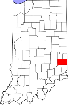
Location of Franklin County in Indiana
This is a list of the Indiana state historical markers in Franklin County.
This is intended to be a complete list of the official state historical markers placed in Franklin County, Indiana, United States by the Indiana Historical Bureau. The locations of the historical markers and their latitude and longitude coordinates are included below when available, along with their names, years of placement, and topics as recorded by the Historical Bureau. There are 12 historical markers located in Franklin County.[1]
Historical markers[]
| Marker title | Image | Year placed | Location | Topics |
|---|---|---|---|---|
| Whitewater Canal[2] | 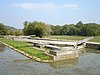
|
? | Northern side of U.S. Route 52 at Gordon's Lock #24 east of Metamora 39°26′49″N 85°7′27.3″W / 39.44694°N 85.124250°W |
Transportation, Business, Industry, and Labor |
| Little Cedar Grove Baptist Church[3] | 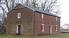
|
1949 | Northern side of the junction of U.S. Route 52 and Little Cedar Road, 3 miles south of Brookville at Mound Haven 39°23′14″N 84°58′54″W / 39.38722°N 84.98167°W |
Religion, Buildings and Architecture |
| [4] | 1965 | Junction of Main (State Road 121 and Toner Streets in southern Laurel 39°29′56.4″N 85°11′26.4″W / 39.499000°N 85.190667°W |
Early Settlement and Exploration, Transportation | |
| Brookville, Franklin County (Platted 1808)[5] | 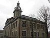
|
1966 | Northern side of U.S. Route 52 in eastern Brookville 39°24′38″N 85°0′38.7″W / 39.41056°N 85.010750°W |
Historic District, Neighborhoods, and Towns, Politics |
| Academy of the Immaculate Conception[6] | 
|
1971 | Junction of Washington and Wein Strasse on the grounds of the academy in Oldenburg 39°20′32″N 85°12′4″W / 39.34222°N 85.20111°W |
Religion, Education |
| Brookville Historic District[7] | 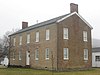
|
1992 | Western lawn of the along Main Street (U.S. Route 52/State Road 1) in Brookville 39°25′10″N 85°0′45.6″W / 39.41944°N 85.012667°W |
Historic District, Neighborhoods, and Towns, Early Settlement and Exploration |
| Old Franklin United Brethren Church[8] | 
|
1995 | 14023 Franklin Church Road near the road's dead end: north of the offices, west of State Road 101, and south of Fairfield Causeway Road, near Brookville 39°30′22″N 84°56′54″W / 39.50611°N 84.94833°W |
Religion, Early Settlement and Exploration |
| [9] | 
|
1995 | 919 N. Main Street in Brookville 39°25′28.6″N 85°0′44″W / 39.424611°N 85.01222°W |
Carnegie Library |
| [10] | 1995 | Junction of Castle and St. Marys Roads, about 2 miles west of Brookville 39°24′29″N 85°3′10.6″W / 39.40806°N 85.052944°W |
Early Settlement and Exploration, American Indian/Native American | |
| [11] | 2002 | Junction of 8th and Mill Streets in the town park in Brookville 39°25′32″N 85°0′29″W / 39.42556°N 85.00806°W |
Sports, Buildings and Architecture | |
| Snow Hill Covered Bridge[12] | 
|
2005 | Carries Snow Hill Road over Johnson Fork near Rockdale 39°19′32″N 84°51′6″W / 39.32556°N 84.85167°W |
Transportation, Buildings and Architecture |
| Brigadier-General CSA Francis Asbury Shoup[13] | 2006 | In the Conwell Cemetery along State Road 121 near Laurel 39°30′16″N 85°11′4″W / 39.50444°N 85.18444°W |
Military, Education, African American |

See also[]
- List of Indiana state historical markers
- National Register of Historic Places listings in Franklin County, Indiana
References[]
- ^ "Indiana Historical Markers by County". State of Indiana. Retrieved 2012-03-15.
- ^ Whitewater Canal, Indiana Historical Bureau, n.d. Accessed 2012-03-14.
- ^ Little Cedar Grove Baptist Church, Indiana Historical Bureau, n.d. Accessed 2012-03-14.
- ^ Whetzel Trace (1818-1823), Indiana Historical Bureau, n.d. Accessed 2012-03-14.
- ^ Brookville, Franklin County (Platted 1808), Indiana Historical Bureau, n.d. Accessed 2012-03-14.
- ^ Academy of the Immaculate Conception, Indiana Historical Bureau, n.d. Accessed 2012-03-14.
- ^ Brookville Historic District, Indiana Historical Bureau, n.d. Accessed 2012-03-14.
- ^ Old Franklin United Brethren Church, Indiana Historical Bureau, n.d. Accessed 2012-03-14.
- ^ Brookville's Carnegie Library, Indiana Historical Bureau, n.d. Accessed 2012-03-14.
- ^ Intersection of Treaty Lines, Indiana Historical Bureau, n.d. Accessed 2012-03-14.
- ^ Brookville's Grandstand, Indiana Historical Bureau, n.d. Accessed 2012-03-14.
- ^ Snow Hill Covered Bridge, Indiana Historical Bureau, n.d. Accessed 2012-03-14.
- ^ Brigadier-General CSA Francis Asbury Shoup, Indiana Historical Bureau, n.d. Accessed 2012-03-14.
External links[]
Municipalities and communities of Franklin County, Indiana, United States | ||
|---|---|---|
| City | ||
| Towns | ||
| Townships | ||
| CDPs | ||
| Other unincorporated communities |
| |
| Footnotes | ‡This populated place also has portions in an adjacent county or counties | |
| ||
Categories:
- Indiana state historical markers
- Tourist attractions in Franklin County, Indiana