List of Indiana state historical markers in Miami County
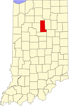
Location of Miami County in Indiana
This is a list of the Indiana state historical markers in Miami County.
This is intended to be a complete list of the official state historical markers placed in Miami County, Indiana, United States by the Indiana Historical Bureau. The locations of the historical markers and their latitude and longitude coordinates are included below when available, along with their names, years of placement, and topics as recorded by the Historical Bureau. There are 2 historical markers located in Miami County.[1]
Historical markers[]
| Marker title | Image | Year placed | Location | Topics |
|---|---|---|---|---|
| Burial Place of Francis Godfroy[2] | 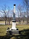
|
1992 | Chief Francis Godfroy Cemetery, along State Road 124 4 miles east of Peru 40°45′4″N 85°59′35″W / 40.75111°N 85.99306°W |
American Indian/Native American, Cemetery |
| [3] | 1992 | County Road 300E (Mississinewa Road), 3 miles east of Peru 40°44′52″N 86°1′13″W / 40.74778°N 86.02028°W |
American Indian/Native American, Buildings and Architecture, Government Institutions |

See also[]
- List of Indiana state historical markers
- National Register of Historic Places listings in Miami County, Indiana
References[]
- ^ "Indiana Historical Markers by County". State of Indiana. Retrieved 2012-03-15.
- ^ Burial Place of Francis Godfroy, Indiana Historical Bureau, n.d. Accessed 2012-03-14.
- ^ House of Chief Richardville, Indiana Historical Bureau, n.d. Accessed 2012-03-14.
External links[]
Municipalities and communities of Miami County, Indiana, United States | ||
|---|---|---|
| City | ||
| Towns | ||
| Townships | ||
| CDP | ||
| Other unincorporated communities | ||
| Ghost towns | ||
| Footnotes | ‡This populated place also has portions in an adjacent county or counties | |
| ||
Categories:
- Indiana state historical markers
- Tourist attractions in Miami County, Indiana