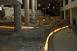
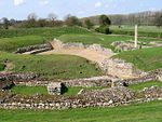
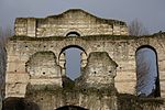
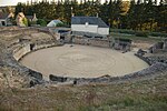
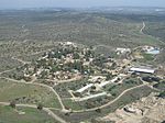
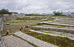
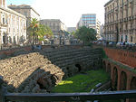
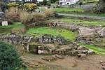
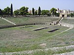
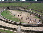
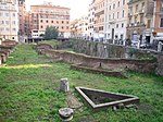
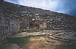
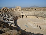
Dyrrhachium
Durrës
Albania
2nd century AD
41°18′44″N 19°26′43″E / 41.312186°N 19.445323°E / 41.312186; 19.445323 (Dyrrhachium (Durres) ) 132x113
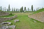
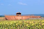
Durrës Amphitheatre
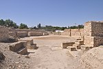
Lambaesis
Lambèse
Algeria
35°29′21″N 6°15′36″E / 35.489247°N 6.259935°E / 35.489247; 6.259935 (Lambaesis (Lambèse) )
Colonia Claudia Caesarea
Cherchell
Algeria
36°36′31″N 2°11′56″E / 36.608740°N 2.198826°E / 36.608740; 2.198826 (Colonia Claudia Caesarea (Cherchell) )
Gemellae
Algeria
34°38′07″N 5°31′22″E / 34.635409°N 5.522764°E / 34.635409; 5.522764 (Gemellae (M'lili) )
[2]
Theveste
Tébessa
Algeria
4th century AD
35°24′04″N 8°07′26″E / 35.401246°N 8.123764°E / 35.401246; 8.123764 (Theveste (Tébessa) )
Aerial Photograph [1]
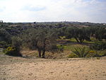
Tipasa
Tipaza
Algeria
36°35′35″N 2°26′44″E / 36.593152°N 2.445456°E / 36.593152; 2.445456 (Tipasa (Tipaza) )
Map of Tipasa
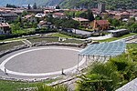
Brigantium
Bregenz
Austria
47°30′02″N 9°44′52″E / 47.500461°N 9.747879°E / 47.500461; 9.747879 (Brigantium (Bregenz) - civil )
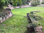
Roman Theatre (Bregenz)
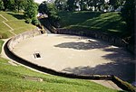
Carnuntum
Petronell
Austria
48°06′36″N 16°51′03″E / 48.1101°N 16.8509°E / 48.1101; 16.8509 (Carnuntum (Petronell) - civil ) 48°07′37″N 16°53′34″E / 48.1269°N 16.8927°E / 48.1269; 16.8927 (Carnuntum (Petronell) - military )
2 amphitheatres [2]
Flavia Solva
Leibnitz
Austria
46°46′00″N 15°34′03″E / 46.766744°N 15.567417°E / 46.766744; 15.567417 (Flavia Solva (Leibnitz) )
[2]
Virunum
Magdalensberg
Austria
46°41′53″N 14°22′01″E / 46.697951°N 14.366943°E / 46.697951; 14.366943 (Virunum (Magdalensberg) )
[2]
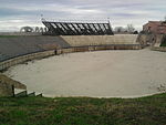
Augusta Traiana
Stara Zagora
Bulgaria
Diocletianopolis (Thrace)
Hisarya
Bulgaria
42°30′10″N 24°42′35″E / 42.502825°N 24.709776°E / 42.502825; 24.709776 (Diocletianopolis (Hisarya) )
[2]
Marcianopolis
Devnya
Bulgaria
43°13′20″N 27°34′10″E / 43.222222°N 27.569444°E / 43.222222; 27.569444 (Marcianopolis (Devnya) )
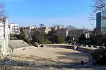
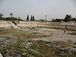
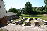
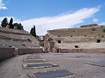
Serdica
Sofia
Bulgaria
3rd century AD
42°41′52″N 23°19′48″E / 42.697803°N 23.330031°E / 42.697803; 23.330031 (Serdica (Sofia) ) 60x43
Amphitheatre of Serdica [3]
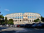
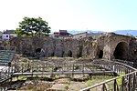
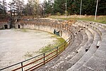
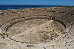
Pietas Iulia Pola
Pula
Croatia
1st century AD
44°52′23″N 13°51′00″E / 44.873176°N 13.850112°E / 44.873176; 13.850112 (Pietas Iulia Pola (Pula) ) 132x105
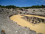
Pula Arena [4]
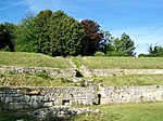
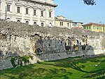
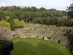
Salona
Solin
Croatia
43°32′18″N 16°28′26″E / 43.538469°N 16.473956°E / 43.538469; 16.473956 (Salonae (Solin) ) 125x100
[3]
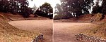
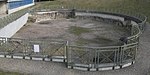
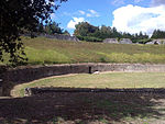
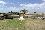
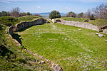
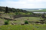
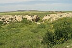
Burnum
Croatia
44°01′09″N 16°01′06″E / 44.0192°N 16.0182°E / 44.0192; 16.0182 (Burnum ) 101x77
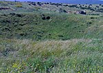
Roman military camp near Šibenik , had a small amphitheatre, recently discovered [2]
Paphos
Cyprus
34°45′18″N 32°24′19″E / 34.754942°N 32.405344°E / 34.754942; 32.405344 (Augusta Paphus (Paphos) )
[2]
Salamis
Cyprus
35°11′08″N 33°54′09″E / 35.185522°N 33.90238°E / 35.185522; 33.90238 ((Salamis) )
Amphitheatre almost vanished.[2]
Calleva Atrebatum
Silchester
England
51°21′32″N 1°04′31″W / 51.35885°N 1.07528°W / 51.35885; -1.07528 (Calleva Atrebatum (Silchester) )
[2] [4] [5]
Camulodunum
Colchester
England
51°53′00″N 0°54′00″E / 51.883333°N 0.9°E / 51.883333; 0.9 (Camulodunum (Colchester) )
Located in 2005 (near Circular Road North)
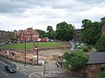
Corinium Dobunnorum
Cirencester
England
2nd century AD
51°42′41″N 1°58′20″W / 51.711500°N 1.972190°W / 51.711500; -1.972190 (Corinium Dobunnorum (Cirencester) )
Cirencester Amphitheatre [2]
Deva Victrix
Chester
England
1st century AD
53°11′21″N 2°53′13″W / 53.189191°N 2.887027°W / 53.189191; -2.887027 (Deva Victrix (Chester) )
Chester Roman Amphitheatre [6] [2]
Durnovaria
Dorchester
England
50°42′28″N 2°26′25″W / 50.70790°N 2.44039°W / 50.70790; -2.44039 (Durnovaria (Dorchester) )
Maumbury Rings [2]
Frilford
England
51°40′15″N 1°21′44″W / 51.670833°N 1.362222°W / 51.670833; -1.362222 (Frilford )
Debated [7] [2]
Iscalis (?)
Charterhouse
England
51°18′19″N 2°43′13″W / 51.3054°N 2.72032°W / 51.3054; -2.72032 (Iscalis (Charterhouse) )
[2]
Isurium Brigantum
Aldborough
England
54°05′17″N 1°22′53″W / 54.088179°N 1.381325°W / 54.088179; -1.381325 (Isurium Brigantum (Aldborough) )
Londinium
London
England
1st century AD
51°30′56″N 0°05′32″W / 51.515546°N 0.092215°W / 51.515546; -0.092215 (Londinium (London) )
Amphitheatre (London)
Noviomagus Reginorum
Chichester
England
50°50′08″N 0°46′21″W / 50.835448°N 0.772496°W / 50.835448; -0.772496 (Noviomagus Reginorum (Chichester) )
[2]
Rutupiae
Richborough
England
51°17′25″N 1°19′36″E / 51.290171°N 1.326534°E / 51.290171; 1.326534 (Rutupiae (Richborough) )
[2]
Viroconium Cornoviorum
Wroxeter
England
52°40′00″N 2°39′00″W / 52.666667°N 2.65°W / 52.666667; -2.65 (Virocorium Cornoviorum (Wroxeter) )
No confirmed amphitheatre found at Wroxeter. Speculation as to purpose of cropmark enclosure includes such.
Venta Icenorum
Caistor St Edmund
England
52°34′48″N 1°17′18″E / 52.579979°N 1.288262°E / 52.579979; 1.288262 (Venta Icenorum (Caistor St Edmund) )
[8] [2]
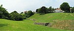
Verulamium
St Albans
England
51°45′14.56″N 0°21′29.88″W / 51.7540444°N 0.3583000°W / 51.7540444; -0.3583000 (Verulamium (St Albans) )
Theatre that had been used as an amphitheatre; note the almost oval shape.
Agedincum
Sens
France
48°12′00″N 3°17′35″E / 48.200036°N 3.292997°E / 48.200036; 3.292997 (Agedincum (Sens) )
[2]
Aginnum
Agen
France
44°12′18″N 0°36′48″E / 44.204938°N 0.613258°E / 44.204938; 0.613258 (Aginnum (Agen) )
Alalia
Aléria
France
Corsica [2]
Apta Julia
Apt
France
43°52′36″N 5°23′51″E / 43.876569°N 5.397437°E / 43.876569; 5.397437 (Apta Julia (Apt) )
No remains of Amphitheatre located. This is the theatre.[2]
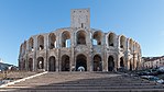
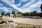
Arelate
Arles
France
1st century AD
43°40′39.92″N 4°37′51.37″E / 43.6777556°N 4.6309361°E / 43.6777556; 4.6309361 (Arelate (Arles) ) 136x109
Arles Amphitheatre .[2] Bullfighting , plays, concerts & events).
Argentomagus
Argenton-sur-Creuse
France
46°35′57″N 1°30′35″E / 46.599061°N 1.509718°E / 46.599061; 1.509718 (Argentomagus (Argenton-sur-Creuse) )
Theatre used also as amphitheatre.[2]
Augustodunum
Autun
France
46°57′06″N 4°17′58″E / 46.951667°N 4.299444°E / 46.951667; 4.299444 (Augustodunum (Autun) ) 154x130
[2]
Augustomagus
Senlis
France
49°12′19″N 2°34′33″E / 49.205191°N 2.575768°E / 49.205191; 2.575768 (Augustomagus (Senlis) )
Theatre used as amphitheatre. Photograph [2]
Augustoritum
Limoges
France
45°49′50″N 1°15′06″E / 45.830446°N 1.251743°E / 45.830446; 1.251743 (Augustoritum (Limoges) )
[2]
Avaricum
Bourges
France
47°05′04″N 2°23′27″E / 47.0845°N 2.39087°E / 47.0845; 2.39087 (Avaricum (Bourges) )
[2]
Beaumont-sur-Oise
France
49°08′46″N 2°17′48″E / 49.146210°N 2.296752°E / 49.146210; 2.296752 ((Beaumont-sur-Oise) )
Burdigala
Bordeaux
France
44°50′51.81″N 0°34′57.57″W / 44.8477250°N 0.5826583°W / 44.8477250; -0.5826583 (Burdigala (Bordeaux) )
[2]
Caesarodunum
Tours
France
1st century AD
47°23′43″N 0°41′47″E / 47.3953°N 0.696394°E / 47.3953; 0.696394 (Caesarodunum (Tours) ) 156x134
Tours Amphitheatre
Cassinomagus
Chassenon
France
45°51′02″N 0°46′08″E / 45.850565°N 0.768990°E / 45.850565; 0.768990 (Cassinomagus (Chassenon) )
[2]
Cahors
France
44°26′44″N 1°26′27″E / 44.4455°N 1.4408°E / 44.4455; 1.4408 (Cassinomagus (Chassenon) )
Discovered in 2007 when digging a parking garage
Cemenelum
Nice
France
43°43′11.84″N 7°16′31.42″E / 43.7199556°N 7.2753944°E / 43.7199556; 7.2753944 (Cemenelum (Nice) )
[2]
Drevant
France
46°41′35″N 2°31′21″E / 46.693051°N 2.522388°E / 46.693051; 2.522388 (Derventum (Drevant) )
Theatre that had been adapted for gladiatorial events[2]
Divodurum
Metz
France
49°07′11″N 6°10′20″E / 49.119631°N 6.172198°E / 49.119631; 6.172198 (Divodurum (Metz) )
Fréjus
France
43°26′4.01″N 6°43′42.60″E / 43.4344472°N 6.7285000°E / 43.4344472; 6.7285000 (Forum Iulium (Fréjus) )
Arènes de Fréjus [2]
Gennes
France
47°20′6.75″N 0°14′19.44″W / 47.3352083°N 0.2387333°W / 47.3352083; -0.2387333 (Geinum (Gennes) )
[2]
Grannus
Grand
France
48°23′07″N 5°29′28″E / 48.385268°N 5.491047°E / 48.385268; 5.491047 ((Grand) )
[9]
A "half amphitheatre", distinguished from a normal theatre by its oval layout.[2]
Béziers
France
43°20′23″N 3°12′51″E / 43.3396°N 3.2141°E / 43.3396; 3.2141 (Julia Baeterrae Septimanorum (Béziers) )
[2]
Juliobona
Lillebonne
France
49°31′04″N 0°32′12″E / 49.517815°N 0.536603°E / 49.517815; 0.536603 (Juliobona (Lillebonne) )
A half-amphitheatre.[2]
Limonum
Poitiers
France
46°34′41″N 0°20′23″E / 46.5781°N 0.33965°E / 46.5781; 0.33965 (Limonum (Poitiers) )
[10] [2]
Lugdunum
Lyon
France
1st century AD
45°46′13.79″N 4°49′50.15″E / 45.7704972°N 4.8305972°E / 45.7704972; 4.8305972 (Lugdunum (Lyon) )
Amphitheatre of the Three Gauls [2]
Lutetia
Paris
France
1st century AD
48°50′41.99″N 2°21′10.46″E / 48.8449972°N 2.3529056°E / 48.8449972; 2.3529056 (Lutetia (Paris) )
Arènes de Lutèce [2]
Mediolanum Santonum
Saintes
France
45°44′45″N 0°38′39″W / 45.745892°N 0.644060°W / 45.745892; -0.644060 (Mediolanum Santonum (Saintes) )
[11] [2]
Montbouy
France
47°52′22″N 2°49′09″E / 47.872894°N 2.819046°E / 47.872894; 2.819046 (Montbuoy )
Narbo Martius
Narbonne
France
43°11′01″N 3°00′15″E / 43.1836°N 3.0042°E / 43.1836; 3.0042 (Narbo Martius (Narbonne) )
No amphitheatre has ever been located at Narbonne[2]
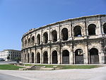
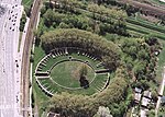
Nemausus
Nîmes
France
1st century AD
43°50′5.69″N 4°21′34.75″E / 43.8349139°N 4.3596528°E / 43.8349139; 4.3596528 (Nemausus (Nimes) ) 133x101
Arena of Nîmes .[2] Bullfighting , plays, concerts & events).
Samarobriva
Amiens
France
49°32′02″N 2°10′28″E / 49.534020°N 2.174333°E / 49.534020; 2.174333 (Samarobriva (Amiens) )
[12] Now underground and buried [2]
Segodunum
Rodez
France
44°21′06″N 2°34′10″E / 44.3518°N 2.56939°E / 44.3518; 2.56939 (Segodunum (Rodez) )
[2]
Tolosa
Toulouse
France
43°36′53″N 1°23′52″E / 43.614780°N 1.397841°E / 43.614780; 1.397841 (Tolosa (Toulouse) )
[2]
Vesontio
Besançon
France
47°14′21″N 6°00′58″E / 47.239279°N 6.015977°E / 47.239279; 6.015977 (Vesontio (Besançon) )
[2]
Perigueux
France
45°10′58″N 0°42′48″E / 45.1827°N 0.7134°E / 45.1827; 0.7134 (Vesuna Petrucorriorum (Perigueux) )
[2]
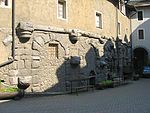
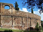
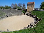
Augusta Treverorum
Trier
Germany
2nd century AD
49°44′53″N 6°38′57″E / 49.748019°N 6.649105°E / 49.748019; 6.649105 (Augusta Treverorum (Trier) ) 70.54 x 47.50
Trier Amphitheater
Castra Vetera
Germany
51°38′15″N 6°28′22″E / 51.637517°N 6.472900°E / 51.637517; 6.472900 (Castra Vetera )
Near Xanten
Colonia Ulpia Traiana
Xanten
Germany
51°40′02″N 6°27′05″E / 51.667200°N 6.451251°E / 51.667200; 6.451251 (Ulpia Traiana (Xanten) )
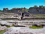
Corinth
Corinth
Greece
37°54′35″N 22°53′31″E / 37.909824°N 22.892078°E / 37.909824; 22.892078 (Corinth (Corinth) )
[2]
Gortyn
Gortyn
Greece
35°03′29″N 24°57′30″E / 35.058004°N 24.958405°E / 35.058004; 24.958405 (Gortyn (Gortyn) )
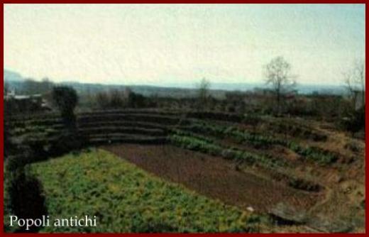
Map of Gortyn, showing amphitheatre This is incorrect. It is a great theatre, long mistaken for an amphitheatre, but clearly D shaped from aerial photos. The actual amphitheatre lies under the church in the village of Agioi Deka, built over the arena where the 10 saints were martyred. The shape of the arena can be made out in surrounding buildings.[2]
Aquincum
Budapest
Hungary
47°34′03″N 19°02′53″E / 47.567577°N 19.047985°E / 47.567577; 19.047985 (Aquincum (Budapest) - civil )
Aquincum Civil Amphitheatre [2]
Aquincum
Budapest
Hungary
47°31′59″N 19°02′21″E / 47.532947°N 19.039066°E / 47.532947; 19.039066 (Aquincum (Budapest) - military )
Aquincum Military Amphitheatre [2]
Gorsium
Tác
Hungary
[2]
Caesarea Maritima
Caesarea
Israel
32°30′24″N 34°53′51″E / 32.506568°N 34.897378°E / 32.506568; 34.897378 (Caesarea Maritima )
[2]
Eleutheropolis
Beit Guvrin
Israel
31°36′30″N 34°53′38″E / 31.6082°N 34.8939°E / 31.6082; 34.8939 (Eleutheropolis )
[13] [2]
Scythopolis
Bet She'an
Israel
32°29′55″N 35°30′05″E / 32.498508°N 35.501446°E / 32.498508; 35.501446 (Scythopolis (Bet She'an) )
[2]
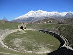
Abella
Avella
Italy
40°57′41″N 14°36′30″E / 40.961454°N 14.608316°E / 40.961454; 14.608316 (Avella )
Photograph
Abellinum
Avellino
Italy
40°55′00″N 14°47′00″E / 40.91667°N 14.78333°E / 40.91667; 14.78333 (Abellinum (Avellino) )
[2]
Acelum
Asolo
Italy
45°48′00″N 11°55′00″E / 45.8°N 11.91667°E / 45.8; 11.91667 (Acelum (Asolo) )
[2]
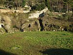
Alba Fucens
Albe
Italy
42°04′38″N 13°24′44″E / 42.0772°N 13.4123°E / 42.0772; 13.4123 (Alba Fucens (Albe) )
Photograph [2]
Alba Longa (?)
Albano Laziale
Italy
41°43′58″N 12°39′54″E / 41.732720°N 12.664948°E / 41.732720; 12.664948 (Alba Longa (Albano Laziale) )
Photograph [2]
Albingaunum
Albenga
Italy
44°02′38″N 8°12′41″E / 44.043859°N 8.211315°E / 44.043859; 8.211315 (Albingaunum (Albenga) )
[2]
Allifae
Alife
Italy
41°19′32″N 14°20′06″E / 41.325586°N 14.334989°E / 41.325586; 14.334989 (Allifae (Alife) )
Altinum
Altino
Italy
45°32′57″N 12°24′00″E / 45.5492°N 12.4001°E / 45.5492; 12.4001 (Altinum (Altino) )
[14]
Amiternum
L'Aquila
Italy
42°24′02″N 13°18′22″E / 42.400513°N 13.306014°E / 42.400513; 13.306014 (Amiternum (L'Aquila) )
[15] [2]
Ancona
Italy
43°37′29″N 13°30′43″E / 43.6246°N 13.5119°E / 43.6246; 13.5119 ((Ancona) )
[2]
Antium
Anzio
Italy
41°27′00″N 12°37′00″E / 41.45°N 12.61667°E / 41.45; 12.61667 (Antium (Anzio) )
[2]
Aquileia
Italy
45°46′07″N 13°21′56″E / 45.76861°N 13.36556°E / 45.76861; 13.36556 (Aquileia )
[2]
Aquinum
Aquino
Italy
41°30′N 13°42′E / 41.5°N 13.7°E / 41.5; 13.7 (Aquinum (Aquino) )
Now completely disappeared, buried beneath the Autostrada.[2]
Ariminum
Rimini
Italy
44°03′36″N 12°34′29″E / 44.059939°N 12.574804°E / 44.059939; 12.574804 (Ariminum (Rimini) )
[2]
Arretium
Arezzo
Italy
43°27′38″N 11°52′49″E / 43.460570°N 11.880326°E / 43.460570; 11.880326 (Arretium (Arezzo) )
[2]
Asculum
Ascoli Piceno
Italy
42°51′20″N 13°34′15″E / 42.855678°N 13.570776°E / 42.855678; 13.570776 (Asculum (Ascoli Piceno) )
[16]
Assisium
Assisi
Italy
43°04′16″N 12°37′13″E / 43.071079°N 12.620270°E / 43.071079; 12.620270 (Assisium (Assisi) )
[17] [2]
Augusta Bagiennorum
Bene Vagienna
Italy
44°33′23″N 7°50′59″E / 44.556327°N 7.849728°E / 44.556327; 7.849728 (Augusta Bene Vagienna (Augusta Bagiennorum) )
[2]
Augusta Praetoria Salassorum
Aosta
Italy
45°44′27″N 7°19′24″E / 45.740766°N 7.323419°E / 45.740766; 7.323419 (Augusta Praetoria Salassorum (Aosta) )
[2]
Beneventum
Benevento
Italy
41°07′56″N 14°46′04″E / 41.132266°N 14.767640°E / 41.132266; 14.767640 (Beneventum (Benevento) )
[18]
Cales
Calvi
Italy
41°12′05″N 14°08′16″E / 41.201408°N 14.137759°E / 41.201408; 14.137759 (Cales (Calvi) )
[2]
Canusium
Canosa di Puglia
Italy
41°13′19″N 16°03′22″E / 41.222051°N 16.055983°E / 41.222051; 16.055983 (Canusium (Canosa di Puglia) )
[2]
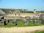
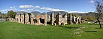
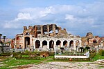
Capua
Santa Maria Capua Vetere
Italy
41°05′09″N 14°15′00″E / 41.085931°N 14.250105°E / 41.085931; 14.250105 (Capua ) 167x137
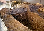
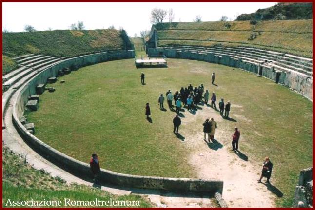
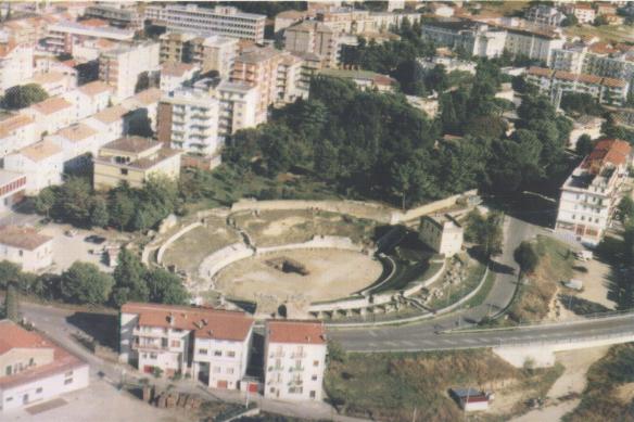
Just to the south, currently being excavated beneath the Piazza Adriano are the remains of another amphitheatre, believed to predate the standing one. Amphitheatre of Capua
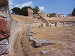
Caralis
Cagliari
Italy
2nd century AD
39°13′26″N 9°06′48″E / 39.223914°N 9.113216°E / 39.223914; 9.113216 (Caralis (Cagliari) ) 93x79
Roman Amphitheatre of Cagliari
Carsulae
Italy
42°38′22″N 12°33′33″E / 42.6395°N 12.5591°E / 42.6395; 12.5591 (Carsulae )
[19] [2]
Casinum
Cassino
Italy
41°28′58″N 13°49′25″E / 41.482732°N 13.823544°E / 41.482732; 13.823544 (Casinum (Cassino) )
Photograph [2]
Catania
Italy
37°30′26″N 15°05′07″E / 37.507335°N 15.085354°E / 37.507335; 15.085354 (Catăna (Catania) )
Amphitheatre of Catania [5] [2]
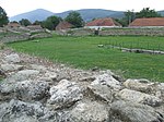
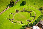
Civitas Camunnorum
Cividate Camuno
Italy
45°56′37″N 10°16′52″E / 45.9435°N 10.281°E / 45.9435; 10.281 (Civitas Camunnorum (Cividate Camuno) )
Estimated capacity: 5500 people.[6] Civitas Camunnorum
Cumae
Italy
40°50′31″N 14°03′21″E / 40.841929°N 14.055903°E / 40.841929; 14.055903 (Cumae )
Photograph [2]
Egnatia
Anazzo
Italy
40°53′16″N 17°23′28″E / 40.887799°N 17.391103°E / 40.887799; 17.391103 (Egnatia (Anazzo) )
Photograph [2]
Eporedia
Ivrea
Italy
45°28′04″N 7°53′16″E / 45.4678°N 7.88769°E / 45.4678; 7.88769 (Eporedia (Ivrea) )
[2]
Fabrateria Nova
San Giovanni Incarico
Italy
41°31′08″N 13°33′11″E / 41.518807°N 13.552995°E / 41.518807; 13.552995 (Fabrateria Nova (San Giovanni Incarico) )
Photograph
Falerone
Italy
43°06′04″N 13°29′47″E / 43.1011°N 13.4964°E / 43.1011; 13.4964 (Falerio Picenus (Falerone) )
Falerii Novi
Italy
42°18′10″N 12°21′39″E / 42.302694°N 12.360894°E / 42.302694; 12.360894 (Falerii Novi )
[20] [2]
Fidenae
Italy
A wooden amphitheatre collapsed here in AD 27, killing at least 20,000.[7]
Fermo
Italy
[21]
Florentia
Florence
Italy
43°46′09″N 11°15′34″E / 43.769228°N 11.259521°E / 43.769228; 11.259521 (Florentia (Florence) )
Roman Amphitheatre of Florence [2]
Formiae
Formia
Italy
41°16′00″N 13°37′00″E / 41.26667°N 13.61667°E / 41.26667; 13.61667 (Formiae (Formia) )
[2]
Forum Novum
Vescovio
Italy
[22]
Forum Traiani - Sardinia
Fordongianus
Italy
39°59′36″N 8°48′17″E / 39.993215°N 8.804670°E / 39.993215; 8.804670 (Forum Traiani (Fordongianus) )
partially excavated, mostly built of wood
Frosinone
Italy
39°35′37″N 8°28′54″E / 39.593526°N 8.481682°E / 39.593526; 8.481682 (Frusinum (Frosinone) )
[2]
Grumentum
Italy
40°17′14″N 15°54′42″E / 40.287320°N 15.911550°E / 40.287320; 15.911550 (Grumentum )
[2]
Herdoniae
Ordona
Italy
41°18′38″N 15°37′23″E / 41.3105°N 15.6231°E / 41.3105; 15.6231 (Herdoniae (Ordona) )
[2]
Himera
Termini Imerese
Italy
37°59′16″N 13°41′37″E / 37.987800°N 13.693664°E / 37.987800; 13.693664 (Himera (Termini Imerese) )
Photograph [2]
Hispellum
Spello
Italy
42°59′45″N 12°39′55″E / 42.995938°N 12.665265°E / 42.995938; 12.665265 (Hispellum (Spello) )
[23] [2]
Histonium
Vasto
Italy
42°06′41″N 14°42′28″E / 42.111279°N 14.707821°E / 42.111279; 14.707821 (Histonium (Vasto) )
[24] [2]
Interamna Nahars
Terni
Italy
42°33′35″N 12°38′36″E / 42.5598°N 12.6433°E / 42.5598; 12.6433 (Interamna Nahars (Terni) )
[25] [2]
Interamnia Praetutiana
Teramo
Italy
42°39′29″N 13°42′11″E / 42.658115°N 13.703109°E / 42.658115; 13.703109 (Interamna Praetutiana(Teramo) )
Photograph [2]
Lanuvium
Lanuvio
Italy
41°41′00″N 12°42′00″E / 41.68333°N 12.7°E / 41.68333; 12.7 (Lanuvium (Lanuvio) )
[26] Photograph [2]
Larinum
Larino
Italy
41°48′20″N 14°54′59″E / 41.805529°N 14.916364°E / 41.805529; 14.916364 (Larinum (Larino) )
Photograph [2]
Libarna
Italy
44°42′21″N 8°52′04″E / 44.705942°N 8.867859°E / 44.705942; 8.867859 (Libarna )
[27] [28] [2]
Liternum
Lago di Patria
Italy
40°55′01″N 14°01′46″E / 40.917073298049765°N 14.029566265509363°E / 40.917073298049765; 14.029566265509363 (Liternum )
[2]
Lucca
Italy
43°50′43″N 10°30′22″E / 43.845320°N 10.506166°E / 43.845320; 10.506166 (Lucca )
[2]
Lucera
Italy
41°30′30″N 15°20′42″E / 41.5083°N 15.3449°E / 41.5083; 15.3449 ((Lucera) )
Lucera's amphitheatre [2]
Lucus Feroniae
Italy
42°07′48″N 12°35′41″E / 42.129874°N 12.594746°E / 42.129874; 12.594746 (Lucus Feroniae )
[2]
Luna
Luni
Italy
44°03′45″N 10°01′20″E / 44.062573°N 10.022085°E / 44.062573; 10.022085 (Luna (Luni) )
[2]
Lupiae
Lecce
Italy
40°21′09″N 18°10′23″E / 40.352473°N 18.172944°E / 40.352473; 18.172944 (Lupiae (Lecce) )
[2]
Marruvium
San Benedetto dei Marsi
Italy
42°00′23″N 13°37′39″E / 42.0065°N 13.6276°E / 42.0065; 13.6276 (Marruvium (San Benedetto dei Marsi) )
Mediolanum
Milan
Italy
2nd century AD
45°27′25″N 9°10′43″E / 45.457026°N 9.178663°E / 45.457026; 9.178663 (Mediolanum (Milan) )
Milan amphitheatre
Mevania
Bevagna
Italy
42°56′13″N 12°36′55″E / 42.936912°N 12.615350°E / 42.936912; 12.615350 (Mevania (Bevagna) )
[29]
Minturnae
Minturno
Italy
41°14′30″N 13°45′50″E / 41.241630°N 13.763832°E / 41.241630; 13.763832 (Minturnae (Minturno) )
[30]
Neapolis
Naples
Italy
40°51′07″N 14°15′20″E / 40.851843°N 14.255639°E / 40.851843; 14.255639 (Neapolis (Naples) )
[31]
Nora
Pula, Sardinia
Italy
Unexcavated [32] (english)[2]
Nuvlana
Nola
Italy
40°55′40″N 14°31′13″E / 40.927722°N 14.520287°E / 40.927722; 14.520287 (Nuvlana (Nola) )
Ocriculum
Otricoli
Italy
42°24′43″N 12°28′01″E / 42.411882°N 12.466898°E / 42.411882; 12.466898 (Ocriculum (Otricoli) )
[33] [34]
Ostia
Ostia Antica
Italy
41°45′14″N 12°17′24″E / 41.753898°N 12.289925°E / 41.753898; 12.289925 (Ostia Antica (Ostia) )
New discovery [35] [36] [37]
Paestum
Italy
40°25′21″N 15°00′23″E / 40.422409°N 15.006500°E / 40.422409; 15.006500 (Paestum )
[2]
Patavium
Padua
Italy
45°24′42″N 11°52′45″E / 45.411630°N 11.879132°E / 45.411630; 11.879132 (Patavium (Padua) )
The arena has been built upon, its site commemorated in the Arena Chapel [2]
Peltuinum
Italy
42°17′13″N 13°37′24″E / 42.286878°N 13.623418°E / 42.286878; 13.623418 (Peltuinum )
[2]
Pollentia
Pollenzo
Italy
44°41′05″N 7°53′45″E / 44.684739°N 7.895866°E / 44.684739; 7.895866 (Pollentia (Pollenzo) )
[2]
Pompeii
Pompei
Italy
1st century BC
40°45′05″N 14°29′42″E / 40.751264°N 14.494970°E / 40.751264; 14.494970 (Pompeii )
Amphitheatre of Pompeii
Puteoli
Pozzuoli
Italy
1st century AD
40°49′33″N 14°07′31″E / 40.825919°N 14.125313°E / 40.825919; 14.125313 (Puteoli (Pozzuoli) ) 147x117
Flavian Amphitheater ; a 2nd minor amphitheater buried beneath the nearby subway line.[2]
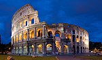
Roma
Rome
Italy
1st century AD
41°53′25″N 12°29′33″E / 41.890177°N 12.492395°E / 41.890177; 12.492395 (Colosseum ) 189x156
Colosseum
Roma
Rome
Italy
3rd century AD
41°53′15″N 12°30′54″E / 41.887569°N 12.515047°E / 41.887569; 12.515047 (Amphitheatrum Castrense )
Amphitheatrum Castrense [38]
Roma
Rome
Italy
1st century AD
41°53′24″N 12°29′42″E / 41.889882°N 12.494881°E / 41.889882; 12.494881 (Ludus Magnus )
Ludus Magnus , a "training amphitheatre". No longer extant are the Amphitheater of Statilius Taurus or the Amphitheater of Nero .
Rudiae
Italy
40°20′03″N 18°08′50″E / 40.3342°N 18.1473°E / 40.3342; 18.1473 (Rudiae )
[2]
Rusellae
Roselle
Italy
1st century AD
42°49′42″N 11°09′33″E / 42.828364°N 11.159210°E / 42.828364; 11.159210 (Rusellae (Roselle) )
[39] [2]
Scolacium
Borgia
Italy
38°49′12″N 16°35′00″E / 38.82°N 16.5833°E / 38.82; 16.5833 (Scolacium (Borgia) )
Photograph [2]
Segusium
Susa
Italy
45°08′00″N 7°02′42″E / 45.133356°N 7.045136°E / 45.133356; 7.045136 (Segusium (Susa) )
[2]
Spoletium
Spoleto
Italy
42°44′19″N 12°44′21″E / 42.738489°N 12.739059°E / 42.738489; 12.739059 (Spoletium (Spoleto) )
[2]
Suasa
Castelleone di Suasa
Italy
43°37′29″N 12°59′12″E / 43.6247°N 12.9867°E / 43.6247; 12.9867 (Suasa (Castelleone di Suasa) )
[2]
Sulci
Sant'Antioco
Italy
39°04′26″N 8°27′05″E / 39.073911°N 8.451355°E / 39.073911; 8.451355 (Sulci (Sant'Antioco) )
partially excavated, mostly built of wood [40] (english)
Sutrium
Sutri
Italy
42°14′21″N 12°13′44″E / 42.239028°N 12.228974°E / 42.239028; 12.228974 (Sutrium (Sutri) )
[2]
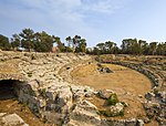
Syracusae
Syracuse
Italy
37°04′27″N 15°16′44″E / 37.074178°N 15.278904°E / 37.074178; 15.278904 (Syracusae (Syracuse) )
Roman amphitheatre of Syracuse [2]
Teate Marrucinorum
Chieti
Italy
42°20′43″N 14°09′45″E / 42.345175°N 14.162512°E / 42.345175; 14.162512 (Teate Marrucinorum (Chieti) )
[2]
Telesia
Telese Terme
Italy
41°13′26″N 14°30′04″E / 41.223857°N 14.501014°E / 41.223857; 14.501014 (Telesia (Telese Terme) )
[2]
Tharros
Cabras
Italy
39°52′36″N 8°26′27″E / 39.876583°N 8.440699°E / 39.876583; 8.440699 (Tharros (Cabras) ) 46.47x46.47
circular, unexcavated, mostly built of wood [41] (english) [42]
Tibur
Tivoli
Italy
41°57′39″N 12°47′53″E / 41.960705°N 12.798095°E / 41.960705; 12.798095 (Tibur (Tivoli) )
[2]
Monteleone Sabino
Italy
42°13′43″N 12°52′03″E / 42.228480°N 12.867593°E / 42.228480; 12.867593 (Trebula Mutuesca (Monteleone Sabino) )
Tusculum
Italy
[2]
Tutere
Todi
Italy
42°46′43″N 12°24′48″E / 42.778637°N 12.413282°E / 42.778637; 12.413282 (Tutere (Todi) )
[2]
Urbs Salvia
Urbisaglia
Italy
43°12′03″N 13°23′14″E / 43.2009°N 13.3872°E / 43.2009; 13.3872 (Urbs Salvia (Urbisaglia) )
Picture (?) [2]
Veleia
Italy
44°47′06″N 9°43′24″E / 44.785057°N 9.723301°E / 44.785057; 9.723301 (Veleia )
[2]
Venafrum
Venafro
Italy
41°28′58″N 14°02′47″E / 41.482710°N 14.046255°E / 41.482710; 14.046255 (Venafrum (Venafro) )
[2]
Venusia
Venosa
Italy
40°58′11″N 15°49′35″E / 40.969681°N 15.826380°E / 40.969681; 15.826380 (Venusia (Venosa) )
[2]
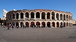
Verona
Verona
Italy
1st century AD
45°26′20″N 10°59′40″E / 45.439006°N 10.994400°E / 45.439006; 10.994400 (Verona ) 152x123
Verona Arena is still functional.
Villa of the Antonines
Genzano di Roma
Italy
41°41′34″N 12°41′46″E / 41.692832°N 12.696152°E / 41.692832; 12.696152 (Villa of the Antonines )
[8]
Volsinii
Bolsena
Italy
42°39′01″N 11°59′24″E / 42.650256°N 11.990112°E / 42.650256; 11.990112 (Volsinii (Bolsena) )
[2]
Zagarolo
Italy
41°51′31″N 12°49′09″E / 41.858487°N 12.819272°E / 41.858487; 12.819272 (Zagarolo )
Botrus
Batroun
Lebanon
34°15′12″N 35°39′38″E / 34.253315°N 35.660419°E / 34.253315; 35.660419 (Botrus (Batroun) )
[2]
Cyrene
Libya
32°49′29″N 21°51′03″E / 32.824585°N 21.850739°E / 32.824585; 21.850739 (Cyrene )
[2]
Leptis Magna
Libya
32°37′56″N 14°18′33″E / 32.632251°N 14.309281°E / 32.632251; 14.309281 (Leptis Magna )
[2]
Ptolemais
Libya
32°42′29″N 20°56′44″E / 32.707946°N 20.945587°E / 32.707946; 20.945587 (Ptolemais )
[43] [2]
Sabratha
Libya
32°48′14″N 12°29′38″E / 32.803934°N 12.494008°E / 32.803934; 12.494008 (Sabratha )
[2]
Lixus
Morocco
35°11′59″N 6°06′31″W / 35.199735°N 6.108586°W / 35.199735; -6.108586 (Lixus )
Amphitheater of Lixus [44] [2]
Ulpia Noviomagus Batavorum
Nijmegen
The Netherlands
51°51′41″N 6°02′45″E / 51.861286°N 6.045742°E / 51.861286; 6.045742 (Ulpia Noviomagus Batavorum (Nijmegen) )
No longer extant, but traced out in the street paving of the present-day Rembrandstraat with a few bits of its foundations still visible
Bobadela
Portugal
40°21′40″N 7°53′36″W / 40.361098°N 7.893427°W / 40.361098; -7.893427 ((Bobadela) )
[2]
Conímbriga
Portugal
1st century BC
40°06′01″N 8°29′43″W / 40.100360°N 8.495403°W / 40.100360; -8.495403 ((Conímbriga) )
Conímbriga's amphitheatre [2]
Tavira
Portugal
[2]
Micia
Veţel
Romania
45°54′54″N 22°49′02″E / 45.914951°N 22.817234°E / 45.914951; 22.817234 (Veţel (Micia) )
[2]
Porolissum
Moigrad-Porolissum
Romania
47°10′39″N 23°09′15″E / 47.177632°N 23.154054°E / 47.177632; 23.154054 (Porolissum (Moigrad) )
[2]
Ulpia Traiana Sarmizegetusa
Sarmizegetusa
Romania
45°31′00″N 22°47′09″E / 45.516751°N 22.785838°E / 45.516751; 22.785838 (Ulpia Traiana Sarmizegetusa )
[2]
Inveresk
Scotland
[45]
Trimontium
Newstead
Scotland
55°36′09″N 2°40′39″W / 55.6026°N 2.6775°W / 55.6026; -2.6775 (Trimontium (Newstead) )
[46]
Viminacium
Stari Kostolac
Serbia
44°43′N 21°10′E / 44.717°N 21.167°E / 44.717; 21.167 (Viminacium (Stari Kostolac) )
[47]
Carmona
Spain
37°28′11″N 5°39′03″W / 37.469600°N 5.650728°W / 37.469600; -5.650728 ((Carmona) )
[2]
Carthago Nova
Cartagena
Spain
37°36′03″N 0°58′48″W / 37.600771°N 0.980048°W / 37.600771; -0.980048 (Carthago Nova (Cartagena) )
[2]
Corduba
Córdoba
Spain
37°53′03″N 4°47′20″W / 37.884140°N 4.788804°W / 37.884140; -4.788804 (Corduba (Córdoba) )
[48]
Emerita Augusta
Mérida
Spain
1st century BC
38°54′57″N 6°20′16″W / 38.915956°N 6.337893°W / 38.915956; -6.337893 (Emerita Augusta (Mérida) )
Mérida amphitheatre [2]
Emporiae
Empúries
Spain
2nd century AD
42°07′48″N 3°07′03″E / 42.1301°N 3.11741°E / 42.1301; 3.11741 (Emporion (Ampurias) )
[2]
Cáparra
Spain
40°09′51″N 6°06′00″W / 40.1643°N 6.09997°W / 40.1643; -6.09997 (Forum Municipii Flavii Caparensis (Caparra) )
[2]
Italica
Itálica
Spain
2nd century AD[9]
37°26′38″N 6°02′48″W / 37.443816°N 6.046670°W / 37.443816; -6.046670 (Italica ) 157x134
Roman amphitheatre of Italica [2]
Segobriga
Saelices
Spain
39°53′10″N 2°48′50″W / 39.8860°N 2.8140°W / 39.8860; -2.8140 (Segobriga (Saelices) )
[49] [2]
Almodovar del Campo
Spain
38°38′47″N 4°31′06″W / 38.6463°N 4.51827°W / 38.6463; -4.51827 (Sisapo (Almodovar del Campo) )
Excavation began in 2009
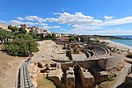
Tarraco
Tarragona
Spain
2nd century AD
41°06′52″N 1°15′32″E / 41.114547°N 1.258817°E / 41.114547; 1.258817 (Tarraco (Tarragona) ) 130x102
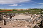
Tarragona Amphitheatre [2]
Augusta Raurica
Augst
Switzerland
47°31′46″N 7°43′14″E / 47.529313°N 7.720602°E / 47.529313; 7.720602 (Augusta Raurica (Augst) )
[2]
Aventicum
Avenches
Switzerland
46°52′52″N 7°02′34″E / 46.881003°N 7.042657°E / 46.881003; 7.042657 (Aventicum (Avenches) )
[2]
Brenodurum (?)
Bern
Switzerland
46°58′33″N 7°27′04″E / 46.975758°N 7.451130°E / 46.975758; 7.451130 (Brenodurum (Bern) )
[2] [10]
Julia Equestris
Nyon
Switzerland
46°23′00″N 6°14′29″E / 46.383451°N 6.241263°E / 46.383451; 6.241263 (Julia Equestris (Nyon) )
[50]
Octodurum
Martigny
Switzerland
46°05′40″N 7°04′24″E / 46.094365°N 7.073460°E / 46.094365; 7.073460 (Octodurum (Martigny) )
[2]
Vindonissa
Windisch
Switzerland
47°28′34″N 8°12′49″E / 47.476249°N 8.213603°E / 47.476249; 8.213603 (Vindonissa (Windisch) )
[2]
Bosra
Syria
32°31′05″N 36°28′48″E / 32.517922°N 36.479872°E / 32.517922; 36.479872 (Bosra )
Dura Europos
Syria
3rd century AD
34°44′59″N 40°43′44″E / 34.749855°N 40.728926°E / 34.749855; 40.728926 (Dura Europos )
[2]
Agbia
Tunisia
[1]
Acholla
Tunisia
35°04′34″N 11°01′08″E / 35.0762°N 11.0188°E / 35.0762; 11.0188 (Acholla )
[1]
Bararus
Tunisia
35°12′43″N 10°47′28″E / 35.211842°N 10.791201°E / 35.211842; 10.791201 (Bararus )
[1]
Tunisia
[1]
Bulla Regia
Tunisia
36°33′37″N 8°45′28″E / 36.560414°N 8.757769°E / 36.560414; 8.757769 (Bulla Regia )
[1]
Tunisia
[1]
Carthago
Carthage
Tunisia
36°51′23″N 10°18′54″E / 36.856336°N 10.314921°E / 36.856336; 10.314921 (Carthago (Carthage) ) 156x128
Carthage amphitheatre
Girba
Djerba
Tunisia
33°41′09″N 10°54′50″E / 33.685822°N 10.913907°E / 33.685822; 10.913907 (Djerba (Djerba) )
Thuburbo Majus
Tunisia
36°23′54″N 9°54′21″E / 36.398212°N 9.905750°E / 36.398212; 9.905750 (Colonia Julia Aurelia Commoda (Thuburbo Majus) )
[51] [1]
Hadrumentum
Sousse
Tunisia
35°49′34″N 10°38′24″E / 35.826°N 10.64°E / 35.826; 10.64 (Hadrumentum (Sousse) )
[1]
Tunisia
36°35′51″N 9°51′39″E / 36.597628°N 9.860814°E / 36.597628; 9.860814 ((Jebel Moraba) )
[1]
Ksar Hellal
Tunisia
[1]
Ksar Lemsa
Tunisia
36°02′05″N 9°41′36″E / 36.034857°N 9.693440°E / 36.034857; 9.693440 ((Ksar Lemsa) )
[52]
Leptis Minor
Tunisia
35°40′42″N 10°51′59″E / 35.678313°N 10.866518°E / 35.678313; 10.866518 (Leptis Minor )
[1]
Mactaris
Maktar
Tunisia
35°51′20″N 9°12′23″E / 35.855562°N 9.206366°E / 35.855562; 9.206366 (Mactaris )
[1]
Tunisia
36°31′40″N 9°53′21″E / 36.5277°N 9.88918°E / 36.5277; 9.88918 (Municipium Aurelium Commodum (Henchir Bou Cha) )
[53]
Bouficha
Tunisia
36°15′00″N 10°23′49″E / 36.250003°N 10.397047°E / 36.250003; 10.397047 (Pheradi Maius (Sidi Khalifa) )
[1]
Pupput
Hammamet, Tunisia
Tunisia
36°24′00″N 10°37′00″E / 36.4°N 10.616667°E / 36.4; 10.616667 (Pupput (Hammamet) )
[1]
Oum El Abouab
Tunisia
36°09′49″N 9°46′32″E / 36.163516°N 9.775575°E / 36.163516; 9.775575 (Seressi )
[1]
Sicca Veneria
El Kef
Tunisia
36°11′10″N 8°42′00″E / 36.186°N 8.7°E / 36.186; 8.7 (Sicca Veneria (El Kef) )
[1]
Simitthus
Chemtou
Tunisia
36°29′25″N 8°34′49″E / 36.490397°N 8.580217°E / 36.490397; 8.580217 (Simitthus (Chemtou) )
Map of Simitthus Photograph [1]
Sufetula
Sbeitla
Tunisia
35°14′37″N 9°06′52″E / 35.243627°N 9.114540°E / 35.243627; 9.114540 (Sufetula (Sbeitla) )
Map of Sufetula [1]
Thaenae
Tunisia
34°39′20″N 10°40′23″E / 34.655531°N 10.673080°E / 34.655531; 10.673080 (Thaenae )
Thapsus
Tunisia
35°37′09″N 11°02′32″E / 35.619145°N 11.042257°E / 35.619145; 11.042257 (Thapsus )
[1]
Thibaris
Tunisia
36°30′17″N 9°04′54″E / 36.504680°N 9.081555°E / 36.504680; 9.081555 (Thignica (Ain Tounga) )
[1]
Thignica
Tunisia
36°31′40″N 9°21′42″E / 36.527815°N 9.361791°E / 36.527815; 9.361791 (Thignica (Ain Tounga) )
[2]
Thimisua
Tunisia
36°18′39″N 9°19′09″E / 36.310720°N 9.319186°E / 36.310720; 9.319186 (Thimisua (Gaafour) )
[1]
Thuburbo Minus
Tebourba
Tunisia
36°49′46″N 9°50′28″E / 36.829485°N 9.841089°E / 36.829485; 9.841089 (Thurburbo Minus (Thebourba) )
The amphitheatre here was destroyed at the end of the 17th century during the construction of a bridge.[1] Herbermann, Charles, ed. (1913). "Thuburbo Minus" Catholic Encyclopedia
Thugga
Tunisia
36°25′27″N 9°13′02″E / 36.4242°N 9.21733°E / 36.4242; 9.21733 ((Thugga) )
[2]
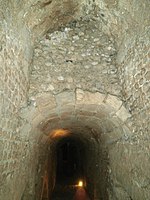
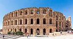
Thysdrus
El Djem
Tunisia
3rd century
35°17′47″N 10°42′25″E / 35.2964°N 10.7069°E / 35.2964; 10.7069 (Thysdrus (El Djem) - Large )
Amphitheatre of El Jem
Uchi Maius
Tunisia
36°24′44″N 9°05′07″E / 36.4123°N 9.08526°E / 36.4123; 9.08526 (Uchi Maius )
[2]
Tunisia
35°57′31″N 10°26′28″E / 35.958633°N 10.441163°E / 35.958633; 10.441163 (Ulissipira )
[1]
Enfida
Tunisia
36°08′02″N 10°22′39″E / 36.133958°N 10.377445°E / 36.133958; 10.377445 (Upenna (Enfida) )
Nothing now remains of Upenna amphitheatre.[2]
Uthina
Oudna
Tunisia
36°36′31″N 10°10′10″E / 36.608681°N 10.169365°E / 36.608681; 10.169365 (Uthina (Oudna) )
[54]
Utica
Tunisia
37°03′09″N 10°03′26″E / 37.052482°N 10.057350°E / 37.052482; 10.057350 (Utica )
2 amphitheatres [1]
Anazarbus
Turkey
37°14′39″N 35°53′42″E / 37.244079°N 35.894983°E / 37.244079; 35.894983 (Anazarbus )
[55]
Mastaura (Caria)
Turkey
37°57′23″N 28°20′30″E / 37.956332°N 28.341756°E / 37.956332; 28.341756 (Mastaura )
[56]
Pergamon
Bergama
Turkey
39°07′33″N 27°10′28″E / 39.125747°N 27.174432°E / 39.125747; 27.174432 (Pergamon (Bergama) )
Map
Isca Augusta
Caerleon
Wales
51°36′29″N 2°57′25″W / 51.608056°N 2.956889°W / 51.608056; -2.956889 (Isca Augusta (Caerleon) )
Caerleon amphitheatre [2]
Moridunum
Carmarthen
Wales
51°51′43″N 4°17′48″W / 51.862004°N 4.296705°W / 51.862004; -4.296705 (Moridunum (Carmarthen) )
[2]
Tomen y Mur
Wales
52°55′55″N 3°55′24″W / 52.931914°N 3.923463°W / 52.931914; -3.923463 ((Tomen-y-Mur) )
near Llan Ffestiniog [57] [2]
Venta Silurum
Caerwent
Wales
51°36′45″N 2°45′59″W / 51.612381°N 2.766406°W / 51.612381; -2.766406 (Venta Silurum (Caerwent) )
[2]


