List of covered bridges in Kentucky

Below is a list of covered bridges in Kentucky. There are eleven authentic covered bridges in the U.S. state of Kentucky, and they are all historic.[1] A covered bridge is considered authentic not due to its age, but by its construction. An authentic bridge is constructed using trusses rather than other methods such as stringers, a popular choice for non-authentic covered bridges.
Bridges[]
Extant[]


Former[]
This transport-related list is incomplete; you can help by . (October 2021) |
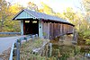
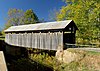
| Name | Image | County | Location | Built | Length | Crosses | Ownership | Truss | Notes |
|---|---|---|---|---|---|---|---|---|---|
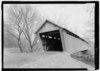
| Mount Zion Covered Bridge[2] | 
|
Washington | Mooresville 37°49′40″N 85°15′23″W / 37.82778°N 85.25639°W |
1871-2021 | 258 feet (79 m) | Beech Fork | Kentucky Department of Highways | Burr | Also called Beech Fork Covered Bridge[3] Lost to fire on March 9, 2021.[4] |
See also[]
- List of bridges on the National Register of Historic Places in Kentucky
- World Guide to Covered Bridges
References[]
- ^ "12 Historic Covered Bridges in Kentucky". Only in Your State. Leaf Group Lifestyle. Retrieved 17 May 2020.
- ^ a b c d e f g h i j k l "National Register Information System". National Register of Historic Places. National Park Service. July 9, 2010.
- ^ a b c d e Wright, David W. (2009). World Guide to Covered Bridges (2009 ed.). Concord, New Hampshire: National Society for Preservation of Covered Bridges. pp. 33–36. ISBN 978-0-692-00617-7.
- ^ "Updates to the 2009 World Guide to Covered Bridges" (PDF). National Society for Preservation of Covered Bridges. 20 July 2021. Retrieved 21 July 2021.
Further reading[]
Robert W. M. Laughlin; Melissa C. Jurgensen (2007). Kentucky's Covered Bridges. Charleston, South Carolina: Arcadia Publishing. ISBN 978-0-738-54404-5.
External links[]
| Wikimedia Commons has media related to Covered bridges in Kentucky. |
- National Society for the Preservation of Covered Bridges
- Lexington Visitors Center article about the state's covered bridges
Categories:
- Lists of covered bridges in the United States
- Covered bridges in Kentucky
- Kentucky transportation-related lists
- Lists of buildings and structures in Kentucky