List of covered bridges in Washington (state)

Below is a list of covered bridges in Washington state. There are five authentic covered bridges in the U.S. state of Washington,[1][2] and one of them is historic. A covered bridge is considered authentic not due to its age, but by its construction. An authentic bridge is constructed using trusses rather than other methods such as stringers, a popular choice for non-authentic covered bridges.
Extant[]
| Name | Image | County | Location | Built | Length | Crosses | Ownership | Truss | Notes |
|---|---|---|---|---|---|---|---|---|---|
| Cedar Creek Covered Bridge[1] | Clark | Woodland 45°56′18″N 122°35′1″W / 45.93833°N 122.58361°W |
1995 | 83 feet (25 m) | Cedar Creek | Howe | Also called Lynch or Grist Mill Covered Bridge | ||
| Grays River Covered Bridge[3] | 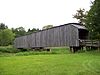
|
Wahkiakum | Grays River 46°21′17″N 123°34′47″W / 46.35472°N 123.57972°W |
1905, 1908, 1989 | 158 feet (48 m) | Grays River | County of Wahkiakum | Howe | |
| Johnson Covered Bridge[1] | Pierce | Gig Harbor 47°19′7″N 122°39′46″W / 47.31861°N 122.66278°W |
2005 | 46 feet (14 m) | Whiskey Creek | Howe | |||
| Little Mountain Covered Bridge[1] | Klickitat | Trout Lake 45°59′29″N 121°29′46″W / 45.99139°N 121.49611°W |
1987 | 60 feet (18 m) | White Salmon River | Queen | Also called Farmgate Homestead and Trout Lake Farm Covered Bridge[4] | ||
| Schafer Farm Bridge[1] | Grays Harbor | Montesano 47°3′47″N 123°31′2″W / 47.06306°N 123.51722°W |
1966 | 72 feet (22 m) | Lagoon | Private | Howe |

Former[]
This transport-related list is incomplete; you can help by . (October 2021) |
| Name | Image | County | Location | Built | Length | Crosses | Ownership | Truss | Notes |
|---|---|---|---|---|---|---|---|---|---|
| Manning-Rye Covered Bridge[3] | 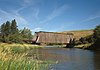
|
Whitman | Colfax 46°55′42″N 117°24′52″W / 46.92833°N 117.41444°W |
ca. 1918 | 163 feet (50 m) | Palouse River | Private | Howe | Also called Harpole, Colfax, and Road Covered Bridge; destroyed by wildfire[2] |
See also[]
- List of bridges on the National Register of Historic Places in Washington (state)
- World Guide to Covered Bridges
References[]
- ^ a b c d e Wright, David W. (2009). World Guide to Covered Bridges (2009 ed.). Concord, New Hampshire: National Society for Preservation of Covered Bridges. pp. 156–157. ISBN 978-0-692-00617-7.
- ^ a b "Updates to the 2009 World Guide to Covered Bridges" (PDF). National Society for Preservation of Covered Bridges. 29 November 2020. Retrieved 10 January 2021.
- ^ a b "National Register Information System". National Register of Historic Places. National Park Service. July 9, 2010.
- ^ "Little Mountain Covered Bridge". Bridgehunter.com. James Baughn. Retrieved 23 May 2020.
External links[]
| Wikimedia Commons has media related to Covered bridges in Washington (state). |
- National Society for the Preservation of Covered Bridges
- Only in Your State article about the state's covered bridges
Categories:
- Lists of covered bridges in the United States
- Covered bridges in Washington (state)
- Washington (state) transportation-related lists
- Lists of buildings and structures in Washington (state)