List of covered bridges in Connecticut

Below is a list of covered bridges in Connecticut. As of 2021, there were nine authentic covered bridges in the U.S. state of Connecticut; three of these are historic.[1]:20 A covered bridge is considered authentic not due to its age, but by its construction. An authentic bridge is constructed using trusses rather than other methods such as stringers, a popular choice for non-authentic covered bridges.
Bridges[]
| Name | Image | County | Location | Built | Length | Crosses | Ownership | Truss | Notes |
|---|---|---|---|---|---|---|---|---|---|
| The Barn Yard Covered Bridge[2] | Tolland | Ellington 41°53′7″N 72°27′53″W / 41.88528°N 72.46472°W |
2021 | 56 feet (17 m) | Belding Brook | Town | |||
| Blackwell Brook Bridge[3] | Windham | Brooklyn 41°47′53″N 71°58′55″W / 41.79806°N 71.98194°W |
2010 | 35 feet (11 m) | Blackwell Brook | Howe | |||
| Bull's Bridge[4] | 
|
Litchfield | Kent 41°40′32″N 73°30′35″W / 41.67556°N 73.50972°W |
ca. 1870 | 109 feet (33 m) | Housatonic River | Town of Kent | Town | |
| Comstock's Bridge[4] | 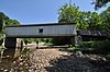
|
Middlesex | East Hampton 41°33′11″N 72°26′57″W / 41.55306°N 72.44917°W |
1840, 1868, rebuilt 2011[3] | 95 feet (29 m) | Salmon River | State of Connecticut | Howe | Has an adjacent 36 feet (11 m) pony queen truss bridge[5] |
| Gold Mine Bridge[3] | New London | Norwich 41°31′9″N 72°7′38″W / 41.51917°N 72.12722°W |
2015 | 60 feet (18 m) | stream | Private | Town | ||
| Huckleberry Hill Bridge[1]:21–22 | Hartford | Avon 41°47′10″N 72°54′31″W / 41.78611°N 72.90861°W |
1968 | 36 feet (11 m) | Pond outlet | Town of Avon | Pratt variant | ||
| Johnsonville Village Bridge[1]:26–27 | Middlesex | Johnsonville Village 41°29′45″N 72°27′59″W / 41.49583°N 72.46639°W |
1976[5] | 60 feet (18 m) | Moodus River | Private | Multiple king with arch | Also called Bicentennial Bridge[5] | |
| West Cornwall Covered Bridge[4] | 
|
Litchfield | West Cornwall 41°52′18″N 73°21′52″W / 41.87167°N 73.36444°W |
1864 | 173 feet (53 m) | Housatonic River | Town of Cornwall | Town | Also called Hart Covered Bridge |
| Worthington Pond Farm Bridge[1]:28–29 | Tolland | Somers 42°1′1″N 72°24′49″W / 42.01694°N 72.41361°W |
2002 | 62 feet (19 m) | Pond outlet | Private | Town with arch |

See also[]
- List of bridges on the National Register of Historic Places in Connecticut
- World Guide to Covered Bridges
References[]
- ^ Jump up to: a b c d Evans, Benjamin D. and June R. (2004). New England's Covered Bridges. Lebanon, NH: University Press of New England. pp. 17-30. ISBN 1-58465-320-5.
- ^ "Updates to the 2009 World Guide to Covered Bridges" (PDF). National Society for Preservation of Covered Bridges. 20 July 2021. Retrieved 21 July 2021.
- ^ Jump up to: a b c "Updates to the 2009 World Guide to Covered Bridges" (PDF). National Society for Preservation of Covered Bridges. 19 February 2020. Retrieved 25 April 2020.
- ^ Jump up to: a b c "National Register Information System". National Register of Historic Places. National Park Service. July 9, 2010.
- ^ Jump up to: a b c Wright, David W. (2009). World Guide to Covered Bridges (2009 ed.). Concord, New Hampshire: National Society for Preservation of Covered Bridges. p. 6. ISBN 978-0-692-00617-7.
Further reading[]
Caswell, William S., Jr. (2011). Connecticut and Rhode Island Covered Bridges. Charleston, South Carolina: Arcadia Publishing. ISBN 978-0-73857540-7.
External links[]
| Wikimedia Commons has media related to Covered bridges in Connecticut. |
- National Society for the Preservation of Covered Bridges
- Visit Connecticut article about the state's covered bridges
Categories:
- Lists of covered bridges in the United States
- Covered bridges in Connecticut
- Connecticut transportation-related lists
- Lists of buildings and structures in Connecticut