List of crossings of the Chao Phraya River

The Chao Phraya River flows through Central Thailand from the confluence of the Ping and Nan Rivers in Nakhon Sawan Province southward to its mouth in Samut Prakan Province, where it drains into the Gulf of Thailand. The river has long served as an important channel of water transport, although it was only after the opening of Rama VI Bridge in 1927 that a permanent land transport structure existed over the river. This page lists permanent crossings of the Chao Phraya, starting from the river mouth and continuing upstream to its source.
List[]
| Crossing | Date opened | Photo | Type | Total length (m) |
Location | Coordinates | Notes | |
|---|---|---|---|---|---|---|---|---|
| Samut Prakan Province | ||||||||
| Kanchanaphisek Bridge | 2007 | 
|
Cable-stayed bridge | 951 m | Phra Pradaeng District, Samut Prakan | 13°38′05″N 100°32′15″E / 13.634831°N 100.537477°E | The bridge was designed by Parsons Brinckerhoff. The bridge is part of the Outer Ring Road network, thus there is a toll for its use. | |
| Bhumibol 2 Bridge | 2006 | 
|
Cable-stayed bridge | 582m | Phra Pradaeng District, Samut Prakan | 13°39′55″N 100°32′22″E / 13.66528°N 100.53944°E | The unofficial name "Mega Bridge" was also widely used. | |
| Bangkok | ||||||||
| Bhumibol 1 Bridge | 2006 | 
|
Cable-stayed bridge | 702m | Yan Nawa District, Bangkok, and Phra Pradaeng District, Samut Prakan | 13°39′55″N 100°32′22″E / 13.66528°N 100.53944°E | The unofficial name "Mega Bridge" was also widely used. | |
| Rama IX Bridge | 1987 | 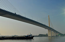
|
Cable-stayed bridge | 781.20 m | Rat Burana and Yan Nawa Districts, Bangkok | 13°40′55″N 100°31′08″E / 13.682058°N 100.519001°E | The bridge was named in honour of King Bhumibol Adulyadej's 60th birthday; the opening date coincides with the King's birthday. It was the first cable-stayed bridge in Thailand and had the second longest cable-stayed span in the world when it opened in 1987. | |
| Krungthep Bridge | 1959 | 
|
Bascule bridge Truss bridge |
626.25 m | Thonburi and Bang Kho Laem Districts, Bangkok | 13°42′4″N 100°29′30″E / 13.70111°N 100.49167°E | Constructed by Fuji Car Manufacturing Co., Ltd, with a budget of 31,912,500 baht. | |
| Rama III Bridge | 1999 | 
|
Box girder bridge | 2,170 m | Thonburi and Bang Kho Laem Districts, Bangkok | 13°42′05″N 100°29′33″E / 13.701519°N 100.492619°E | Designed to alleviate traffic congestion on the adjacent Krungthep Bridge. Known as the New Krungthep Bridge. | |
| Taksin Bridge | 1982 | 
|
Box girder bridge | 1,791 m | Khlong San, Bang Rak, and Sathon Districts, Bangkok | 13°43′08″N 100°30′45″E / 13.718791°N 100.512543°E | The bridge was designed with a large gap between opposing traffic directions to accommodate a canceled mass transit system. The disused foundations were eventually adapted for the BTS Skytrain, with train services across the bridge beginning on 15 May 2009. | |
| Phra Pok Klao Bridge | 1984 | 
|
Box girder bridge | 745 m | Phra Nakhon and Khlong San Districts, Bangkok | 13°44′20″N 100°29′56″E / 13.738999°N 100.498981°E | The bridge was designed to alleviate traffic congestion on the adjacent Memorial Bridge. The bridge is composed of 3 viaducts, with the central viaduct designed to carry future mass transit links. As of December 2007 there are no plans to use the central viaduct. | |
| Memorial Bridge | 1932 | 
|
Truss bridge | 678 m | Phra Nakhon and Thonburi Districts, Bangkok | 13°44′21″N 100°29′51″E / 13.73917°N 100.49750°E | Most commonly known as Phra Phutthayotfa Bridge (สะพานพระพุทธยอดฟ้า), after King Phra Phutthayotfa Chulalok (Rama I), the first king of the Chakri Dynasty. | |
| MRT Blue Line tunnel | 2019 | 
|
Rail tunnel | ?? | Phra Nakhon and Bangkok Yai Districts, Bangkok | Between Sanam Chai and Itsaraphap MRT stations. It is the only railway tunnel under a river in Thailand | ||
| Phra Pin Klao Bridge | 1973 | 
|
Box girder bridge | 658 m | Near the Grand Palace Phra Nakhon and Bangkok Noi Districts, Bangkok |
13°45′43″N 100°29′28″E / 13.76194°N 100.49111°E | Named after Pinklao, vice-king of Siam 1851-66. | |
| Rama VIII Bridge | 2002 | 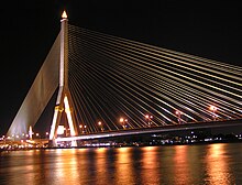
|
Cable-stayed bridge | 475 m | Phra Nakhon and Bang Phlat Districts, Bangkok | 13°46′9″N 100°29′48.5″E / 13.76917°N 100.496806°E | The world's largest asymmetric cable-stayed bridges. The bridge was designed to alleviate traffic congestion on the adjacent Phra Pin-klao Bridge and Krung Thon Bridge. | |
| Krung Thon Bridge | 1958 | 
|
Truss bridge | 648.90 m | Dusit and Bang Phlat Districts, Bangkok | 13°46′51″N 100°30′11″E / 13.780892°N 100.502951°E | Known as Sang Hi Bridge | |
| MRT Blue Line bridge | 2019 |
|
Box girder bridge | ?? | Bang Sue and Bang Phlat Districts, Bangkok | Between Bang Pho and Bang O MRT stations. | ||
| Si Rat–Outer Ring Road Expressway | 2016 | Bang Sue and Bang Phlat Districts, Bangkok | ||||||
| Rama VI Bridge | 1927 | 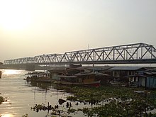
|
Truss bridge | 441.44 m | Bang Sue and Bang Phlat Districts, Bangkok | 13°48′47″N 100°30′57″E / 13.813108°N 100.515826°E | Rail-road bridge of the southern line | |
| Nonthaburi Province | ||||||||
| Light Red Line commuter railway bridge | 2012 |
|
Box girder bridge | ?? | Bang Sue, and Bang Kruai District, Nonthaburi | 13°48′47″N 100°30′57″E / 13.813108°N 100.515826°E | Running parallel to Rama VI Bridge | |
| Rama VII Bridge | 1992 | 
|
Box girder bridge | 933.19 m | Bang Sue District, Bangkok, and Bang Kruai District, Nonthaburi | 13°48′50″N 100°30′52″E / 13.813775°N 100.514442°E | ||
| Maha Chesadabodindranusorn Bridge | 2015 | 
|
Extradosed bridge | 460 m | Mueang Nonthaburi District, Nonthaburi | 13°51′16″N 100°28′47″E / 13.854331°N 100.479841°E | ||
| Rama V Bridge | 2002 | Box girder bridge | 430 m | Mueang Nonthaburi District | 13°49′57″N 100°29′43″E / 13.832496°N 100.495312°E | |||
| MRT Purple Line bridge | 2006 |
|
Box girder bridge | 400 m | Mueang Nonthaburi District | 13°52′12″N 100°28′35″E / 13.87011°N 100.47647°E | Between Phra Nang Klao Bridge and Sai Ma MRT stations. Adjacent to Phra Nang Klao Bridge. | |
| Phra Nang Klao Bridge | 1985 | 
|
Box girder bridge | 329.10 m | Mueang Nonthaburi District | 13°52′13″N 100°28′34″E / 13.870362°N 100.476194°E | ||
| 2008 |
|
Box girder bridge | 299.10 m | Mueang Nonthaburi District | 13°52′17″N 100°28′34″E / 13.871497°N 100.476215°E | Running parallel to Phra Nang Klao Bridge. | ||
| Rama IV Bridge | 2006 | 
|
Box girder bridge | 278 m | Pak Kret District, Nonthaburi | 13°54′57″N 100°29′38″E / 13.915802°N 100.493875°E | ||
| Pathum Thani Province | ||||||||
| Nonthaburi Bridge | 1959 |
|
Truss bridge | 260.20 m | Mueang Pathum Thani District, Pathum Thani, and Pakkret District, Nonthaburi | 13°56′52″N 100°32′06″E / 13.947656°N 100.535052°E | Known as Nuan Chawi Bridge. | |
| 2009 | Box girder bridge | 278.10 m | Mueang Pathum Thani District | 13°57′50″N 100°32′10″E / 13.96383°N 100.536°E | ||||
| 1984 | Box girder bridge | 239.10 m | Mueang Pathum Thani District | 14°01′34″N 100°32′20″E / 14.02609°N 100.53882°E | ||||
| Phra Nakhon Si Ayutthaya Province | ||||||||
| ?? | Box girder bridge | ?? | Bang Sai District, Phra Nakhon Si Ayutthaya, and Sam Khok District, Pathum Thani | |||||
| ?? |
|
Box girder bridge | ?? | Bang Pa-in District, Phra Nakhon Si Ayutthaya | ||||
| ?? |
|
Box girder bridge | ?? | Phra Nakhon Si Ayutthaya District, Phra Nakhon Si Ayutthaya | ||||
| ?? | 
|
Roving bridge | ?? | Phra Nakhon Si Ayutthaya District, Phra Nakhon Si Ayutthaya | ||||
| ?? |
|
Box girder bridge | ?? | Phra Nakhon Si Ayutthaya District, Phra Nakhon Si Ayutthaya | ||||
| Under construction |
|
Box girder bridge | ?? | Bang Ban District, Phra Nakhon Si Ayutthaya | ||||
| Ang Thong Province | ||||||||
| ?? |
|
Box girder bridge | ?? | Pa Mok District, Ang Thong | ||||
| ?? |
|
Box girder bridge | ?? | Mueang District, Ang Thong | ||||
| ?? |
|
Box girder bridge | ?? | Mueang District, Ang Thong | ||||
| ?? |
|
Box girder bridge | ?? | Chaiyo District, Ang Thong | ||||
| Sing Buri Province | ||||||||
| ?? |
|
Box girder bridge | ?? | Phrom Buri District, Sing Buri | ||||
| ?? |
|
Box girder bridge | ?? | Mueang District, Sing Buri | ||||
| ?? |
|
Box girder bridge | ?? | Mueang District, Sing Buri | ||||
| ?? |
|
Box girder bridge | ?? | In Buri District, Sing Buri | ||||
| Chai Nat Province | ||||||||
| ?? |
|
Box girder bridge | ?? | Sapphaya District, Chai Nat | ||||
| Chao Phraya Dam | 1957 | 
|
Barrage dam | 237.5 m | Sapphaya District, Chai Nat | 15°09′29″N 100°10′48″E / 15.158°N 100.180°E | ||
| ?? |
|
Box girder bridge | ?? | Mueang Chai Nat District, Chai Nat | ||||
| 2018 |
|
Box girder bridge | ?? | Mueang Chai Nat District, Chai Nat | Connects Tambon Tha Chai with central municipal area. Construction cost: 510 million baht.[1] | |||
| Nakhon Sawan Province | ||||||||
| 1995 |
|
Box girder bridge | ?? | Phayuha Khiri District, Nakhon Sawan | ||||
| ?? |
|
Box girder bridge | ?? | Mueang Nakhon Sawan District, Nakhon Sawan | ||||
| 1971 |
|
Box girder bridge | ?? | Mueang Nakhon Sawan District, Nakhon Sawan | 15°41′18″N 100°07′25″E / 15.688257°N 100.123594°E | |||
| 1950 |
|
Tied-arch bridge | ?? | Mueang Nakhon Sawan District, Nakhon Sawan | 15°41′18″N 100°07′25″E / 15.688257°N 100.123594°E | Closed for memorial. Open only emergency situation. | ||
| 1993 |
|
Box girder bridge | ?? | Mueang Nakhon Sawan District, Nakhon Sawan | 15°41′18″N 100°07′25″E / 15.688257°N 100.123594°E | |||

See also[]
References[]
- ^ "New Chao Phraya Bridge Opens". Bangkok Post. 16 May 2018. Retrieved 16 May 2018.
External links[]
| Wikimedia Commons has media related to Bridges over the Chao Phraya. |
- Bridges over the Chao Phraya River (in Thai)
Categories:
- Bridges in Thailand
- Crossings of the Chao Phraya River